Enable Location

We need your location to show you interesting places around you

Discover nearby places

Find interesting locations and hidden gems around you

Precise directions

Get accurate directions and distances to places

Your location is never shared with other users. It's only used when you tap the location button.

Old Mauch Chunk Historic District

Log in to your account

Start exploring — it's free

Trusted by 63,329 travelers worldwide

Continue with Google
Continue with Apple
or

We will send you a code to connect

By continuing, you accept our Terms and Conditions and our Privacy Policy

Check your inbox

We've sent a pincode in your inbox. Please enter the code below.

Discussion Reviews 1 Photos
2.5k Popularity

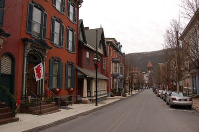
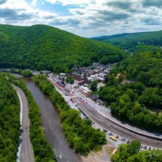
Old Mauch Chunk Historic District, Historic district in Jim Thorpe, Pennsylvania, United States.

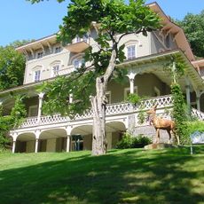
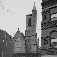
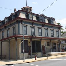
The Old Mauch Chunk Historic District is a historic district with 28 buildings spanning about 40 acres in the center of Jim Thorpe, marked by Renaissance Revival architecture. The collection includes government buildings, a theater, banks, and residential structures from the 1800s.

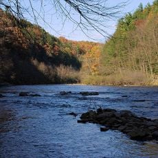
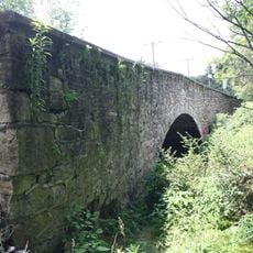
The town was designed in 1831 by engineer John A. Roebling and quickly grew into a major coal mining hub for the region. The buildings date mainly from the early to mid-1800s, when the settlement was booming.

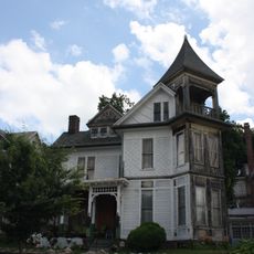
This district represents the center of Jim Thorpe and shows how people lived and worked in a 19th-century mining town. The standing buildings tell stories of the different trades and social classes that existed side by side here.

The district is easy to explore on foot and concentrated within a few blocks of the downtown area, making a comfortable half-day visit possible. Most structures are visible from outside, though some are only open to visitors at certain times.

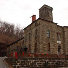
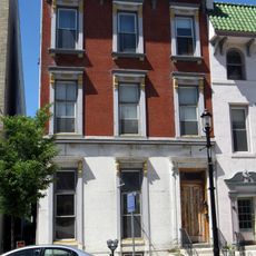
Stone Row is a remarkable grouping of buildings that shows what a 19th-century mining industrial town actually looked like and how it developed. This kind of intact collection is rare, as many American mining towns lost this kind of original character over time.

The community of curious travelers

AroundUs brings together thousands of curated places, local tips, and hidden gems, enriched daily by 60,000 contributors worldwide.

Start exploring
Location
Architectural style
Renaissance Revival architecture
GPS coordinates
40.86222,-75.74306
Latest update
December 13, 2025 11:47
Around this place
Hickory Run State Park
United States of America

Hickory Run State Park

20 km
Beltzville State Park
United States of America

Beltzville State Park

11.4 km
Lehigh Canal
United States of America

Lehigh Canal

15.7 km
Lehigh Gorge State Park
United States of America

Lehigh Gorge State Park

11.6 km
Asa Packer Mansion
United States of America

Asa Packer Mansion

482 m
Harry Packer Mansion
United States of America

Harry Packer Mansion

505 m
Lehigh Gap
United States of America

Lehigh Gap

14.8 km
Carbon County Jail
United States of America

Carbon County Jail

374 m
Turn Hole Tunnel
United States of America

Turn Hole Tunnel

2.8 km
St. Mark's Episcopal Church
United States of America

St. Mark's Episcopal Church

333 m
St. Gabriel's Catholic Parish Complex
United States of America

St. Gabriel's Catholic Parish Complex

21.5 km
Lehigh Gap
United States of America

Lehigh Gap

14.8 km
Little Gap Covered Bridge
United States of America

Little Gap Covered Bridge

18.9 km
Fireman's Drinking Fountain
United States of America

Fireman's Drinking Fountain

16.5 km
Markle Banking & Trust Company Building
United States of America

Markle Banking & Trust Company Building

22 km
Dimmick Memorial Library
United States of America

Dimmick Memorial Library

354 m
Summit Hill High School
United States of America

Summit Hill High School

11.8 km
Tamaqua Historic District
United States of America

Tamaqua Historic District

19.4 km
Slatington Historic District
United States of America

Slatington Historic District

16.8 km
Lansford Historic District
United States of America

Lansford Historic District

12.3 km
Anthracite Bank Building
United States of America

Anthracite Bank Building

20.7 km
George Ormrod House
United States of America

George Ormrod House

20.7 km
Vigilant Fire Company Firemen's Monument
United States of America

Vigilant Fire Company Firemen's Monument

17.5 km
Bridge in Heidelberg Township
United States of America

Bridge in Heidelberg Township

18.2 km
Palmerton Historic District
United States of America

Palmerton Historic District

13 km
Jim Thorpe Lehigh River Access
United States of America

Jim Thorpe Lehigh River Access

733 m
Stony Point Fire Tower
United States of America

Stony Point Fire Tower

18.8 km
Glen Onoko Lehigh River Access
United States of America

Glen Onoko Lehigh River Access

2.7 km
Show the full map
Reviews
Share your experience

No review yet

Discussions
Start a discussion...

No discussion yet

« Old Mauch Chunk Historic District - Historic district in Jim Thorpe, Pennsylvania, United States » is provided by Around Us (aroundus.com). Images and texts are derived from Wikimedia project under a Creative Commons license. You are allowed to copy, distribute, and modify copies of this page, under the conditions set by the license, as long as this note is clearly visible.

Discover hidden gems everywhere you go!

From secret cafés to breathtaking viewpoints, skip the crowded tourist spots and find places that match your style. Our app makes it easy with voice search, smart filtering, route optimization, and insider tips from travelers worldwide. Download now for the complete mobile experience.

Around Us App Screenshot

A unique approach to discovering new places

Le Figaro

All the places worth exploring

France Info

A tailor-made excursion in just a few clicks

20 Minutes

Around Us
Travel Guide & Maps
Download

Send to your phone

QR Code
1

Open the camera app on your mobile.

2

Point at the QR code with your camera. A notification will appear.

3

Tap the notification to open the link.