Enable Location

We need your location to show you interesting places around you

Discover nearby places

Find interesting locations and hidden gems around you

Precise directions

Get accurate directions and distances to places

Your location is never shared with other users. It's only used when you tap the location button.

Log in to your account

Start exploring — it's free

Trusted by 62,995 travelers worldwide

Continue with Google
Continue with Apple
or

We will send you a code to connect

By continuing, you accept our Terms and Conditions and our Privacy Policy

Check your inbox

We've sent a pincode in your inbox. Please enter the code below.

River to River Trail
Discussion Reviews Photo
5.7k Popularity

River to River Trail, Protected hiking route across Illinois, United States

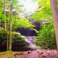
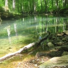
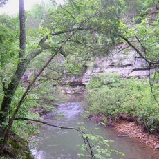
The River to River Trail is a hiking route that stretches through Shawnee National Forest, connecting the Mississippi River with the Ohio River. The path moves through forests, valleys, and alternates between open fields and wooded sections.

The trail was created in the 1990s as a recreational pathway following routes that Native Americans and early European settlers had used before. These historic routes were preserved and made accessible for today's hikers.

Small towns and rural settlements along the way display local crafts and regional traditions that become visible as you walk through. People here have maintained their heritage and share it with those passing through.

The route has marked sections and multiple access points with parking for day trips or longer hikes. Information kiosks and designated camping areas are found along the way to help with planning.

During migration seasons, you can spot a wide variety of bird species moving between the two rivers along the corridor. These periods offer a rare chance to watch hundreds of birds on their journey.

The community of curious travelers

AroundUs brings together thousands of curated places, local tips, and hidden gems, enriched daily by 60,000 contributors worldwide.

Start exploring
Location
GPS coordinates
37.49060,-88.91190
Latest update
December 9, 2025 18:48
Around this place
Giant City State Park
United States of America

Giant City State Park

27.5 km
Saluki Stadium
United States of America

Saluki Stadium

36.2 km
Ferne Clyffe State Park
United States of America

Ferne Clyffe State Park

7.6 km
Giant City Stone Fort Site
United States of America

Giant City Stone Fort Site

29.2 km
Dixon Springs State Park
United States of America

Dixon Springs State Park

24.9 km
Panther Den Wilderness
United States of America

Panther Den Wilderness

18.3 km
Williamson County Jail
United States of America

Williamson County Jail

26.8 km
Cache River State Natural Area
United States of America

Cache River State Natural Area

14.8 km
Mermet Lake State Fish and Wildlife Area
United States of America

Mermet Lake State Fish and Wildlife Area

26 km
Lock and Dam Number 53
United States of America

Lock and Dam Number 53

34.3 km
Heron Pond – Little Black Slough Nature Preserve
United States of America

Heron Pond – Little Black Slough Nature Preserve

14.2 km
Vienna Public Library
United States of America

Vienna Public Library

8.4 km
Carrier Mills Archaeological District
United States of America

Carrier Mills Archaeological District

31.9 km
Stinson Memorial Library
United States of America

Stinson Memorial Library

30.2 km
Bell Smith Springs
United States of America

Bell Smith Springs

22.8 km
Willis Allen House
United States of America

Willis Allen House

26.3 km
John Bridges Tavern and Store Site
United States of America

John Bridges Tavern and Store Site

11 km
Lusk Creek Canyon
United States of America

Lusk Creek Canyon

33 km
Johnson County Courthouse
United States of America

Johnson County Courthouse

8.6 km
Goddard Chapel
United States of America

Goddard Chapel

28.2 km
Campground Church and Cemetery Site
United States of America

Campground Church and Cemetery Site

20.3 km
Thompson Brothers Rock Art
United States of America

Thompson Brothers Rock Art

27.4 km
Williamson County Courthouse
United States of America

Williamson County Courthouse

27 km
St. Anne's Episcopal Church
United States of America

St. Anne's Episcopal Church

30.3 km
St. Paulus Evangelisch Lutherischen Gemeinde
United States of America

St. Paulus Evangelisch Lutherischen Gemeinde

33.2 km
Ed M. Stotlar House
United States of America

Ed M. Stotlar House

27.1 km
John A. Logan College
United States of America

John A. Logan College

32.8 km
AMC Classic Illinois Centre 8
United States of America

AMC Classic Illinois Centre 8

29.4 km
Show the full map
Reviews
Share your experience

No review yet

Discussions
Start a discussion...

No discussion yet

« River to River Trail - Protected hiking route across Illinois, United States » is provided by Around Us (aroundus.com). Images and texts are derived from Wikimedia project under a Creative Commons license. You are allowed to copy, distribute, and modify copies of this page, under the conditions set by the license, as long as this note is clearly visible.

Discover hidden gems everywhere you go!

From secret cafés to breathtaking viewpoints, skip the crowded tourist spots and find places that match your style. Our app makes it easy with voice search, smart filtering, route optimization, and insider tips from travelers worldwide. Download now for the complete mobile experience.

Around Us App Screenshot

A unique approach to discovering new places

Le Figaro

All the places worth exploring

France Info

A tailor-made excursion in just a few clicks

20 Minutes

Around Us
Travel Guide & Maps
Download

Send to your phone

QR Code
1

Open the camera app on your mobile.

2

Point at the QR code with your camera. A notification will appear.

3

Tap the notification to open the link.