Chest opened
+${chestReward.xp} XP
Explorer
NOUVEAU ×${chestReward.collectible.quantity}
tapez pour fermer
Chest locked

Open chests in the app

Around Us is built for your phone — chests unlock when you walk, explore and capture nearby places.

Enable Location

We need your location to show you interesting places around you

Discover nearby places

Find interesting locations and hidden gems around you

Precise directions

Get accurate directions and distances to places

Your location is never shared with other users. It's only used when you tap the location button.

Log in to your account

Start exploring — it's free

Trusted by 72,878 travelers worldwide

Continue with Google
Continue with Apple
or

We will send you a code to connect

By continuing, you accept our Terms and Conditions and our Privacy Policy

Check your inbox

We've sent a pincode in your inbox. Please enter the code below.

Discussion Reviews Photo
1.4k Popularity

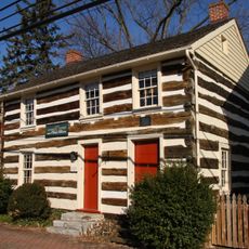
Rocky Run Shelter, Mountain shelter in Washington County, Maryland, US.

Rocky Run Shelter is a two-building accommodation site along the Appalachian Trail with capacity for about 22 people. The complex includes sleeping areas with wooden flooring, a loft space, a covered porch, and a designated fire pit for cooking and warmth.

The original building was constructed in the 1940s by the Civilian Conservation Corps, a work program created during the Great Depression. The Potomac Appalachian Trail Club later expanded the site with additional structures to better serve trail users.

The shelter represents one of fifteen remaining Civilian Conservation Corps structures on the Appalachian Trail, built with logs instead of stone.

The site offers basic shelter and a fire area, but hikers should bring their own gear and supplies. Since it operates on a first-come basis, arriving early during peak season helps secure a spot.

The shelter is one of the few remaining examples of log construction from the Civilian Conservation Corps era on the Appalachian Trail. This makes it a notable reminder of how trail infrastructure was specifically built to withstand mountain conditions and serve generations of hikers.

The community of curious travelers

AroundUs brings together thousands of curated places, local tips, and hidden gems, enriched daily by 60,000 contributors worldwide.

Start exploring
Location
Inception
January 1, 2008
Operator
Potomac Appalachian Trail Club
GPS coordinates
39.46090,-77.63090
Latest update
December 14, 2025 16:40
Around this place
Burnside's Bridge
United States of America

Burnside's Bridge

8.8 km
South Mountain
United States of America

South Mountain

4.5 km
Washington Monument State Park
United States of America

Washington Monument State Park

4.4 km
Greenbrier State Park
United States of America

Greenbrier State Park

8.4 km
Gathland State Park
United States of America

Gathland State Park

6.4 km
Crystal Grottoes
United States of America

Crystal Grottoes

5.7 km
National War Correspondents Memorial
United States of America

National War Correspondents Memorial

6.2 km
Lambs Knoll
United States of America

Lambs Knoll

1.4 km
Dahlgren Chapel
United States of America

Dahlgren Chapel

2.8 km
Bowman House
United States of America

Bowman House

6 km
Turner's and Fox's Gaps Historic District
United States of America

Turner's and Fox's Gaps Historic District

2.8 km
Bennies Hill Road Bridge
United States of America

Bennies Hill Road Bridge

7.8 km
Baltimore & Ohio Railroad Bridge, Antietam Creek
United States of America

Baltimore & Ohio Railroad Bridge, Antietam Creek

8.6 km
Middletown Historic District
United States of America

Middletown Historic District

7.7 km
Hoffman Farm
United States of America

Hoffman Farm

8.8 km
Henry Shoemaker Farmhouse
United States of America

Henry Shoemaker Farmhouse

3.2 km
Crampton's Gap Historic District
United States of America

Crampton's Gap Historic District

6.2 km
Bowlus Mill House
United States of America

Bowlus Mill House

6.2 km
Washington Monument
United States of America

Washington Monument

4.5 km
Burkittsville Historic District
United States of America

Burkittsville Historic District

7.7 km
Boonsboro Historic District
United States of America

Boonsboro Historic District

5.4 km
Geeting Farm
United States of America

Geeting Farm

6.1 km
Shafer's Mill
United States of America

Shafer's Mill

7.9 km
Routzahn-Miller Farmstead
United States of America

Routzahn-Miller Farmstead

4.4 km
Hills, Dales and The Vinyard
United States of America

Hills, Dales and The Vinyard

7 km
Hitt's Mill and Houses
United States of America

Hitt's Mill and Houses

7.5 km
Keedysville Historic District
United States of America

Keedysville Historic District

6.5 km
Stonebraker and Harbaugh–Shafer Building
United States of America

Stonebraker and Harbaugh–Shafer Building

7.5 km
Show the full map
Reviews
Share your experience

No review yet

Discussions
Start a discussion...

No discussion yet

« Rocky Run Shelter - Mountain shelter in Washington County, Maryland, US » is provided by Around Us (aroundus.com). Images and texts are derived from Wikimedia project under a Creative Commons license. You are allowed to copy, distribute, and modify copies of this page, under the conditions set by the license, as long as this note is clearly visible.

Discover hidden gems everywhere you go!

From secret cafés to breathtaking viewpoints, skip the crowded tourist spots and find places that match your style. Our app makes it easy with voice search, smart filtering, route optimization, and insider tips from travelers worldwide. Download now for the complete mobile experience.

Around Us App Screenshot

A unique approach to discovering new places

Le Figaro

All the places worth exploring

France Info

A tailor-made excursion in just a few clicks

20 Minutes

Around Us
Travel Guide & Maps
Download

Send to your phone

QR Code
1

Open the camera app on your mobile.

2

Point at the QR code with your camera. A notification will appear.

3

Tap the notification to open the link.