Chest opened
+${chestReward.xp} XP
Explorer
NOUVEAU ×${chestReward.collectible.quantity}
tapez pour fermer
Chest locked

Open chests in the app

Around Us is built for your phone — chests unlock when you walk, explore and capture nearby places.

Enable Location

We need your location to show you interesting places around you

Discover nearby places

Find interesting locations and hidden gems around you

Precise directions

Get accurate directions and distances to places

Your location is never shared with other users. It's only used when you tap the location button.

Schoharie Creek

Log in to your account

Start exploring — it's free

Trusted by 72,986 travelers worldwide

Continue with Google
Continue with Apple
or

We will send you a code to connect

By continuing, you accept our Terms and Conditions and our Privacy Policy

Check your inbox

We've sent a pincode in your inbox. Please enter the code below.

Schoharie Creek
Discussion Reviews 1 Photos
9.5k Popularity

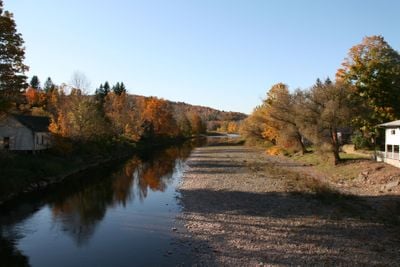
Schoharie Creek, Mountain stream in Catskills region, New York.

Schoharie Creek is a river in the Catskills region of New York that flows about 93 kilometers from Indian Head Mountain. It travels through the Schoharie Valley before joining the Mohawk River system, passing through forests and farmland.

During the American Revolution, farms along the creek supplied food to Colonial forces, giving the region military importance. The valley's agricultural output made it a strategic area during the conflict.

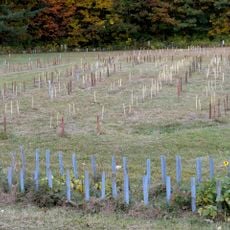
The watershed region maintains 85 percent forest coverage, supporting local environmental preservation initiatives and natural resource management programs.

The area offers several access points along the water for walking and observing the landscape. The best times to visit are spring and fall when the weather is mild and water levels are stable.

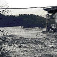
The creek supplies water to New York City through two major reservoirs that also generate power. The Schoharie Reservoir and Blenheim-Gilboa Power Project are crucial to the region's infrastructure.

The community of curious travelers

AroundUs brings together thousands of curated places, local tips, and hidden gems, enriched daily by 60,000 contributors worldwide.

Start exploring
Location
GPS coordinates
42.94118,-74.29263
Latest update
December 10, 2025 15:57
Around this place
Schoharie Creek Bridge collapse
United States of America

Schoharie Creek Bridge collapse

1.7 km
National Shrine of the North American Martyrs
United States of America

National Shrine of the North American Martyrs

1.9 km
Johnson Hall State Historic Site
United States of America

Johnson Hall State Historic Site

11.1 km
Caughnawaga Indian Village Site
United States of America

Caughnawaga Indian Village Site

8.3 km
Schoharie Crossing State Historic Site
United States of America

Schoharie Crossing State Historic Site

546 m
Old Fort Johnson
United States of America

Old Fort Johnson

4.5 km
Tryon County Jail
United States of America

Tryon County Jail

9.4 km
Guy Park
United States of America

Guy Park

6.8 km
Knox Mansion
United States of America

Knox Mansion

9.4 km
Greene Mansion
United States of America

Greene Mansion

8.3 km
Amsterdam City Hall
United States of America

Amsterdam City Hall

2.5 km
United States of America

George Landis Arboretum

17.5 km
Saint Stanislaus Roman Catholic Church Complex
United States of America

Saint Stanislaus Roman Catholic Church Complex

9 km
Mohawk Valley Gateway Overlook pedestrian bridge
United States of America

Mohawk Valley Gateway Overlook pedestrian bridge

8 km
Gloversville Free Library
United States of America

Gloversville Free Library

12.8 km
Chalmers Knitting Mills
United States of America

Chalmers Knitting Mills

7.9 km
Fulton County Courthouse
United States of America

Fulton County Courthouse

9.9 km
Log Cabin Church
United States of America

Log Cabin Church

11.3 km
Downtown Gloversville Historic District
United States of America

Downtown Gloversville Historic District

12.9 km
Guy Park Avenue School
United States of America

Guy Park Avenue School

6.9 km
First United Methodist Church
United States of America

First United Methodist Church

13.1 km
Temple of Israel
United States of America

Temple of Israel

8 km
Gray-Jewett House
United States of America

Gray-Jewett House

7.6 km
Gloversville Armory
United States of America

Gloversville Armory

12.7 km
Kingsboro Historic District
United States of America

Kingsboro Historic District

14.5 km
First Baptist Church
United States of America

First Baptist Church

11.2 km
Gustav Levor House
United States of America

Gustav Levor House

13.1 km
Vrooman Avenue School
United States of America

Vrooman Avenue School

9.6 km
Show the full map
Reviews
Share your experience

No review yet

Discussions
Start a discussion...

No discussion yet

« Schoharie Creek - Mountain stream in Catskills region, New York » is provided by Around Us (aroundus.com). Images and texts are derived from Wikimedia project under a Creative Commons license. You are allowed to copy, distribute, and modify copies of this page, under the conditions set by the license, as long as this note is clearly visible.

Discover hidden gems everywhere you go!

From secret cafés to breathtaking viewpoints, skip the crowded tourist spots and find places that match your style. Our app makes it easy with voice search, smart filtering, route optimization, and insider tips from travelers worldwide. Download now for the complete mobile experience.

Around Us App Screenshot

A unique approach to discovering new places

Le Figaro

All the places worth exploring

France Info

A tailor-made excursion in just a few clicks

20 Minutes

Around Us
Travel Guide & Maps
Download

Send to your phone

QR Code
1

Open the camera app on your mobile.

2

Point at the QR code with your camera. A notification will appear.

3

Tap the notification to open the link.