Sonestown Covered Bridge

Log in to your account

AroundUs is a community-driven map of interesting places, built by curious explorers like you. It grows with every review, story, and photo you share.
Connect to save your favorite spots, contribute locations, and create personalized routes.
By continuing, you accept our Terms and Conditions and our Privacy Policy
Add to collection
Map
Suggest a change
Share

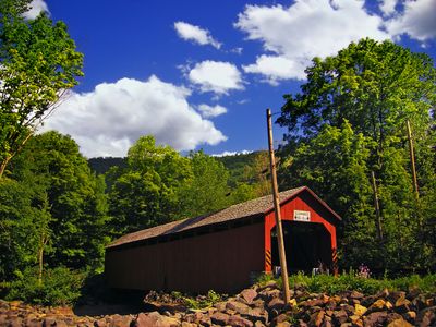
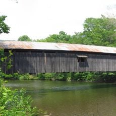
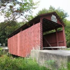
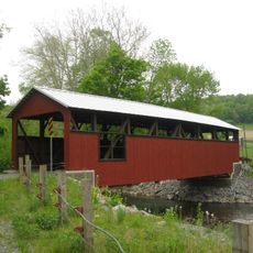
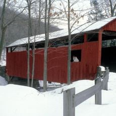
Sonestown Covered Bridge, Covered bridge in Davidson Township, Pennsylvania, United States.

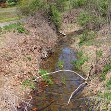
Sonestown Covered Bridge is a wooden road bridge crossing Muncy Creek with the distinctive Burr Truss design pattern. The covered structure protects the internal framework from weather and allows it to carry vehicles and pedestrians across the creek.

Built in the 1850s, this bridge became a crucial transportation link for growing rural communities in the region. It has safely carried generations of travelers and daily commuters across the creek since its construction.

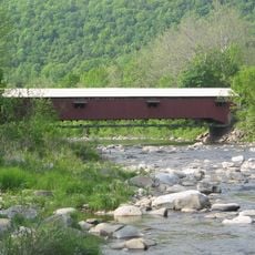
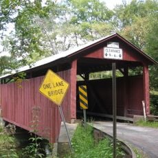
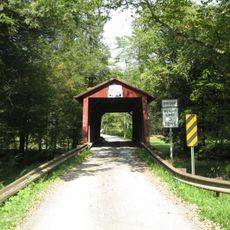
The bridge serves as a daily crossing point for the community, connecting nearby roads and farmland. Its wooden structure has become a familiar landmark that residents pass through regularly.

Access is straightforward since the bridge is part of a public road network and can be reached on foot or by car from either side. Visitors should be aware that the structure remains in active use with regular traffic passing through.

The Burr Truss design combines diagonal beams with vertical supports in a way that distributes heavy loads across the structure. This engineered system has given the bridge remarkable durability over more than 170 years.

Location: Davidson Township

Architectural style: Burr Truss

Length: 34 m

GPS coordinates: 41.34639,-76.55500

Latest update: December 7, 2025 20:46

Photos
Around this place
Show the full map
Ricketts Glen State Park
United States of America

Ricketts Glen State Park

24.6 km
Worlds End State Park
United States of America

Worlds End State Park

14 km
Clemuel Ricketts Mansion
United States of America

Clemuel Ricketts Mansion

19.6 km
Forksville Covered Bridge
United States of America

Forksville Covered Bridge

16.2 km
Hillsgrove Covered Bridge
United States of America

Hillsgrove Covered Bridge

16 km
Loyalsock State Forest
United States of America

Loyalsock State Forest

22.9 km
Plunketts Creek Bridge No. 3
United States of America

Plunketts Creek Bridge No. 3

21.8 km
State Game Lands Number 13
United States of America

State Game Lands Number 13

11.4 km
Central Mountain
United States of America

Central Mountain

18.2 km
Carl E. Stotz Memorial Little League Bridge
United States of America

Carl E. Stotz Memorial Little League Bridge

23.1 km
State Game Lands Number 226
United States of America

State Game Lands Number 226

24.2 km
Eagles Mere Historic District
United States of America

Eagles Mere Historic District

8.1 km
Creasyville Covered Bridge
United States of America

Creasyville Covered Bridge

16.9 km
Sullivan County Courthouse
United States of America

Sullivan County Courthouse

10 km
Eagles Mere Air Museum
United States of America

Eagles Mere Air Museum

8 km
Lairdsville Covered Bridge
United States of America

Lairdsville Covered Bridge

16.9 km
Sam Eckman Covered Bridge No. 92
United States of America

Sam Eckman Covered Bridge No. 92

19.6 km
Lake Rose
United States of America

Lake Rose

21.8 km
Muncy Historic District
United States of America

Muncy Historic District

25 km
Shoemaker Covered Bridge
United States of America

Shoemaker Covered Bridge

21.8 km
Y Covered Bridge No. 156
United States of America

Y Covered Bridge No. 156

17.1 km
Jud Christie Covered Bridge No. 95
United States of America

Jud Christie Covered Bridge No. 95

18.1 km
Cox Run
United States of America

Cox Run

21.9 km
Trout Pond Park
United States of America

Trout Pond Park

21.2 km
Worlds End State Park Family Cabin District
United States of America

Worlds End State Park Family Cabin District

13.5 km
Loyalsock Trail
United States of America

Loyalsock Trail

9.2 km
Houseknecht Farm
United States of America

Houseknecht Farm

20.3 km
Adams Falls
United States of America

Adams Falls

24.1 km
Show the full map
Reviews

Visited this place? Tap the stars to rate it and share your experience / photos with the community! Try now! You can cancel it anytime.

« Sonestown Covered Bridge - Covered bridge in Davidson Township, Pennsylvania, United States » is provided by Around Us (aroundus.com). Images and texts are derived from Wikimedia project under a Creative Commons license. You are allowed to copy, distribute, and modify copies of this page, under the conditions set by the license, as long as this note is clearly visible.

Discover hidden gems everywhere you go!

From secret cafés to breathtaking viewpoints, skip the crowded tourist spots and find places that match your style. Our app makes it easy with voice search, smart filtering, route optimization, and insider tips from travelers worldwide. Download now for the complete mobile experience.

Around Us App Screenshot

A unique approach to discovering new places

Le Figaro

All the places worth exploring

France Info

A tailor-made excursion in just a few clicks

20 Minutes