Hillsgrove Covered Bridge

Log in to your account

AroundUs is a community-driven map of interesting places, built by curious explorers like you. It grows with every review, story, and photo you share.
Connect to save your favorite spots, contribute locations, and create personalized routes.
Continue with Google
Continue with Apple
Continue with X
Continue with Facebook
Continue with email
By continuing, you accept our Terms and Conditions and our Privacy Policy
Create an account
Add to collection
Map
Suggest a change
Share

Hillsgrove Covered Bridge, Covered bridge in Hillsgrove Township, Pennsylvania, United States

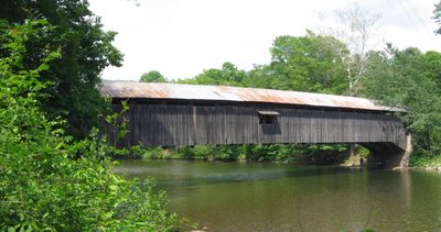
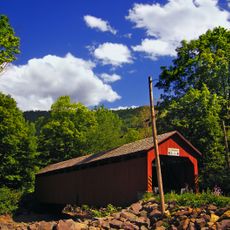
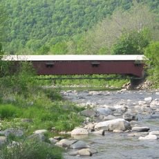
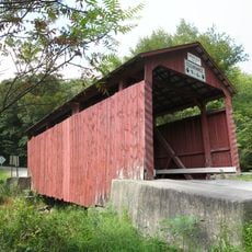
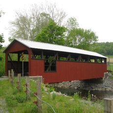
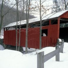
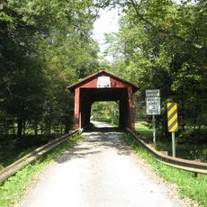
Hillsgrove Bridge is a red wooden structure that spans Loyalsock Creek with Burr arch trusses and long narrow openings fitted with wooden shutters. The bridge displays typical construction methods from its era with heavy timber framing throughout.

Built in 1850, this structure earned recognition on the National Register of Historic Places in 1973 as Sullivan County's first listed bridge. The construction by a young craftsman became a significant example of local bridge building from that era.

The bridge displays rules from the 1800s about speed limits, animal traffic, and fire safety, preserving how local people managed movement across Loyalsock Creek long ago. You can still see these written regulations painted on the wooden structure today.

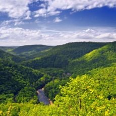
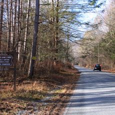
The bridge sits about 2.6 miles northeast of Hillsgrove village and is easy to reach by car. It is a good spot for taking photos or learning about local history from a quieter location.

Between 1870 and 1890, the bridge served as a landing point for lumber rafts moving through the local timber trade network. This role shows how central the bridge was to the region's economy during the height of the logging industry.

Location: Hillsgrove Township

Length: 57 m

GPS coordinates: 41.46080,-76.67080

Latest update: December 10, 2025 16:27

Photos
Around this place
Worlds End State Park
United States of America

Worlds End State Park

8.6 km
Sonestown Covered Bridge
United States of America

Sonestown Covered Bridge

16 km
Clemuel Ricketts Mansion
United States of America

Clemuel Ricketts Mansion

31.6 km
Forksville Covered Bridge
United States of America

Forksville Covered Bridge

6.7 km
Old Loggers Path
United States of America

Old Loggers Path

20 km
Plunketts Creek Bridge No. 3
United States of America

Plunketts Creek Bridge No. 3

12.4 km
Muncy Creek
United States of America

Muncy Creek

30 km
State Game Lands Number 13
United States of America

State Game Lands Number 13

25.5 km
Central Mountain
United States of America

Central Mountain

32.5 km
Eagles Mere Historic District
United States of America

Eagles Mere Historic District

9.2 km
Canfield Island Site
United States of America

Canfield Island Site

33.9 km
St. James Episcopal Church
United States of America

St. James Episcopal Church

30.4 km
Creasyville Covered Bridge
United States of America

Creasyville Covered Bridge

32.8 km
United States of America

Sullivan County Courthouse

15.3 km
Eagles Mere Air Museum
United States of America

Eagles Mere Air Museum

12.5 km
Bridge in Lewis Township
United States of America

Bridge in Lewis Township

25.9 km
Lairdsville Covered Bridge
United States of America

Lairdsville Covered Bridge

28.4 km
Muncy Historic District
United States of America

Muncy Historic District

30.2 km
Reading-Halls Station Bridge
United States of America

Reading-Halls Station Bridge

28.5 km
Y Covered Bridge No. 156
United States of America

Y Covered Bridge No. 156

31.9 km
Jud Christie Covered Bridge No. 95
United States of America

Jud Christie Covered Bridge No. 95

33.8 km
Cox Run
United States of America

Cox Run

30.1 km
Worlds End State Park Family Cabin District
United States of America

Worlds End State Park Family Cabin District

8 km
Loyalsock Trail
United States of America

Loyalsock Trail

7 km
Houseknecht Farm
United States of America

Houseknecht Farm

31.5 km
Grand View Fire Tower
United States of America

Grand View Fire Tower

34.6 km
Holy Cross Orthodox Church, Williamsport, PA
United States of America

Holy Cross Orthodox Church, Williamsport, PA

33.9 km
Rose Valley Lake (Pennsylvania)
United States of America

Rose Valley Lake (Pennsylvania)

28 km
Show the full map
Reviews

Visited this place? Tap the stars to rate it and share your experience / photos with the community! Try now! You can cancel it anytime.

« Hillsgrove Covered Bridge - Covered bridge in Hillsgrove Township, Pennsylvania, United States » is provided by Around Us (aroundus.com). Images and texts are derived from Wikimedia project under a Creative Commons license. You are allowed to copy, distribute, and modify copies of this page, under the conditions set by the license, as long as this note is clearly visible.

Discover hidden gems everywhere you go!

From secret cafés to breathtaking viewpoints, skip the crowded tourist spots and find places that match your style. Our app makes it easy with voice search, smart filtering, route optimization, and insider tips from travelers worldwide. Download now for the complete mobile experience.

Around Us App Screenshot

A unique approach to discovering new places

Le Figaro

All the places worth exploring

France Info

A tailor-made excursion in just a few clicks

20 Minutes