Enable Location

We need your location to show you interesting places around you

Discover nearby places

Find interesting locations and hidden gems around you

Precise directions

Get accurate directions and distances to places

Your location is never shared with other users. It's only used when you tap the location button.

St. John's Lutheran Church

Log in to your account

Join the adventure

Create your free account and start exploring (like 60k+ others)

We will send you a code to connect

or
Continue with Google
Continue with Apple
By continuing, you accept our Terms and Conditions and our Privacy Policy

Check your inbox

We've sent a pincode in your inbox. Please enter the code below.

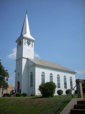
St. John's Lutheran Church, Lutheran church in Walhalla, South Carolina

Description

St. John's is a church building in Walhalla featuring a rectangular main structure with a centered tower and octagonal spire topped design. The building at 301 West Main Street includes a connected brick structure used for educational gatherings and community meetings.

History

The German Colonization Society of Charleston founded this church in 1853 to serve the newly arriving German settlers in the area. The current building was constructed in the late 1850s and has functioned continuously as a place for worship and community gatherings.

Culture

The congregation honors German traditions in its worship style and maintains a connection to the European roots of its founding community. Visitors notice this heritage reflected in how services are conducted and celebrated here.

Practical

The building sits in a central location within Walhalla and is easy to find on Main Street. Visitors planning a visit should check in advance about service times and whether tours outside of regular worship hours can be arranged.

Did you know?

The interior of the building still contains original pine timbers from its construction in the 1850s. These old wood pieces remain visible in the framework and show how builders of that era created the structure.

Location
GPS coordinates
34.76500,-83.06972
Latest update
December 14, 2025 17:40

AroundUs brings together thousands of curated places, local tips, and hidden gems, enriched daily by 60,000 contributors worldwide. Discover all places nearby (South Carolina).

Around this place
Memorial Stadium, Clemson
United States of America

Memorial Stadium, Clemson

22.9 km
Devils Fork State Park
United States of America

Devils Fork State Park

23.7 km
Littlejohn Coliseum
United States of America

Littlejohn Coliseum

22.5 km
Fort Hill
United States of America

Fort Hill

23.2 km
Keowee
United States of America

Keowee

17.3 km
Oconee State Park
United States of America

Oconee State Park

11.7 km
Issaqueena Falls
United States of America

Issaqueena Falls

6.6 km
ESSO Club
United States of America

ESSO Club

22.4 km
United States of America

Bull Sluice

22.4 km
Travelers Rest
United States of America

Travelers Rest

23.3 km
Dick's Creek Falls
United States of America

Dick's Creek Falls

19.7 km
Clemson College Sheep Barn
United States of America

Clemson College Sheep Barn

24 km
President's House
United States of America

President's House

23.9 km
Clemson University Historic District I
United States of America

Clemson University Historic District I

23.5 km
Kings Creek Falls
United States of America

Kings Creek Falls

22.7 km
Ram Cat Alley Historic District
United States of America

Ram Cat Alley Historic District

13.9 km
Lee and Lowry Hall
United States of America

Lee and Lowry Hall

23.4 km
Oconee County Cage
United States of America

Oconee County Cage

270 m
Faith Cabin Library at Seneca Junior College
United States of America

Faith Cabin Library at Seneca Junior College

13.8 km
Seneca Historic District (Seneca, South Carolina)
United States of America

Seneca Historic District (Seneca, South Carolina)

13.7 km
Keil Farm
United States of America

Keil Farm

3.9 km
Retreat Rosenwald School
United States of America

Retreat Rosenwald School

13.8 km
Alexander-Hill House
United States of America

Alexander-Hill House

13.3 km
Oconee County Courthouse
United States of America

Oconee County Courthouse

106 m
Jarrett-Hayes House
United States of America

Jarrett-Hayes House

23 km
Oconee History Museum
United States of America

Oconee History Museum

245 m
Oconee Station State Historic Site
United States of America

Oconee Station State Historic Site

9 km
Oconee State Park Historic District
United States of America

Oconee State Park Historic District

11.6 km
Show the full map
« St. John's Lutheran Church - Lutheran church in Walhalla, South Carolina » is provided by Around Us (aroundus.com). Images and texts are derived from Wikimedia project under a Creative Commons license. You are allowed to copy, distribute, and modify copies of this page, under the conditions set by the license, as long as this note is clearly visible.

Discover hidden gems everywhere you go!

From secret cafés to breathtaking viewpoints, skip the crowded tourist spots and find places that match your style. Our app makes it easy with voice search, smart filtering, route optimization, and insider tips from travelers worldwide. Download now for the complete mobile experience.

Around Us App Screenshot

A unique approach to discovering new places

Le Figaro

All the places worth exploring

France Info

A tailor-made excursion in just a few clicks

20 Minutes

Around Us
Travel Guide & Maps
Download

Send to your phone

QR Code
1

Open the camera app on your mobile.

2

Point at the QR code with your camera. A notification will appear.

3

Tap the notification to open the link.