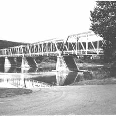
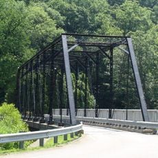
Tionesta Bridge, Road bridge in Tionesta, Pennsylvania, United States.
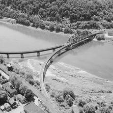
Tionesta Bridge is a road bridge that crosses the Allegheny River near the borough of Tionesta in Forest County, connecting the community with surrounding areas. The structure carries traffic on U.S. Route 62 and Pennsylvania Route 36, serving as a main crossing point in the region.
Built in 1961, this bridge was the first steel girder bridge of its kind to span the Allegheny River between the Pittsburgh area and Kinzua Dam. The construction marked an important upgrade to regional infrastructure and connections.
The bridge functions as a central meeting point for community gatherings and serves as a connection point between different neighborhoods in the Tionesta region.
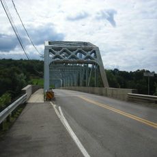
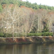
The structure sits just a few inches above the water level and may be submerged for several weeks per year due to operation of the Tionesta Dam. Visitors should be aware of possible water levels, especially during times when the reservoir is being filled.
Located just inches above the water level, this bridge experiences regular submersion for several weeks annually due to the operations of the Tionesta Dam.
Location: Pennsylvania
Inception: 1961
Official opening: 1961
GPS coordinates: 41.49519,-79.46015
Latest update: December 14, 2025 17:40
Drake Well
20.9 km
Cook Forest State Park
31.3 km
Drake Well Museum
21 km
Oil Creek State Park
16.6 km
Hearts Content Scenic Area
27.9 kmTanbark Trail
27.9 kmHickory Creek Wilderness
24.4 km
McClintocksville, Pennsylvania
12.6 km
Sutton-Ditz House
31.9 km
Pithole Stone Arch Bridge
11.3 km
Clarion County Courthouse and Jail
31.8 km
Titusville City Hall
23.1 km
West Hickory Bridge
9.5 km
Allegheny Baptist Church
15.2 km
Jersey Bridge
21.2 km
Tidioute Bridge
21 km
Bridge in Oil Creek Township
25.1 km
Connely-Holeman House
15.9 km
Titusville Historic District
23.3 km
Anthony Wayne Cook Mansion
28 km
Cook Forest State Park River Cabin District
29.3 km
Cook Forest State Park Indian Cabin District
27.6 km
Oil City Pennsylvania Railroad Bridge
21.4 km
Oil City Downtown Commercial Historic District
21.8 km
Oil City South Side Historic District
23.2 km
Oil City North Side Historic District
22.1 km
Beaver Meadows Lake
29.6 km
Cook Forest Tower
28.5 kmVisited this place? Tap the stars to rate it and share your experience / photos with the community! Try now! You can cancel it anytime.
Discover hidden gems everywhere you go!
From secret cafés to breathtaking viewpoints, skip the crowded tourist spots and find places that match your style. Our app makes it easy with voice search, smart filtering, route optimization, and insider tips from travelers worldwide. Download now for the complete mobile experience.
A unique approach to discovering new places❞
— Le Figaro
All the places worth exploring❞
— France Info
A tailor-made excursion in just a few clicks❞
— 20 Minutes