Weir River Farm

Log in to your account

AroundUs is a community-driven map of interesting places, built by curious explorers like you. It grows with every review, story, and photo you share.
Connect to save your favorite spots, contribute locations, and create personalized routes.
Continue with Google
Continue with Apple
Continue with X
Continue with Facebook
Continue with email
By continuing, you accept our Terms and Conditions and our Privacy Policy
Create an account
Add to collection
Map
Suggest a change
Share

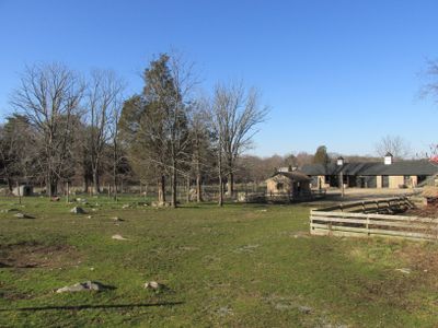
Weir River Farm, Protected farm area in Hingham, Massachusetts, United States.

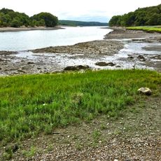
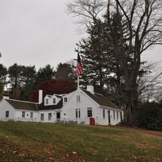
Weir River Farm is a protected agricultural area in Hingham encompassing 75 acres of fields, pastures, oak woodlands, and cedar forests along the Weir River. The property features two miles of walking trails where visitors can explore the grounds and observe farm animals grazing.

The property was owned by artist Polly Thayer Starr before being transferred to The Trustees of Reservations in 1999. This change in ownership marked the beginning of its protection and opening to the public as a preserved agricultural space.

The farm practices agriculture through a community-supported program that delivers organic vegetables and grass-fed meat to local members throughout the year. This direct connection between farmers and families shapes how people relate to the land and food production here.

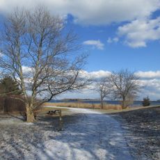
The farm is open to visitors from June through October, offering trail walking, animal observation, and shopping at the farm store. Wear comfortable shoes as trails traverse varied terrain and can be muddy after rain.

From the farm's elevated position, visitors can see the Boston skyline across the fields while Belted Galloway cattle graze nearby. This surprising blend of city views and rural grazing creates an unusual and memorable vantage point.

Location: Massachusetts

GPS coordinates: 42.24000,-70.85360

Latest update: December 12, 2025 09:07

Photos
Around this place
Nantasket Beach
United States of America

Nantasket Beach

3.4 km
Paragon Park
United States of America

Paragon Park

3.2 km
Wompatuck State Park
United States of America

Wompatuck State Park

3.8 km
Bumpkin Island
United States of America

Bumpkin Island

6 km
Great Esker Park
United States of America

Great Esker Park

6.3 km
Webb Memorial State Park
United States of America

Webb Memorial State Park

6.4 km
Josephine M. Hagerty House
United States of America

Josephine M. Hagerty House

4.7 km
Hingham Naval Ammunition Depot
United States of America

Hingham Naval Ammunition Depot

5.2 km
Fort Duvall
United States of America

Fort Duvall

7.5 km
Paragon Park Carousel
United States of America

Paragon Park Carousel

3.4 km
General Benjamin Lincoln House
United States of America

General Benjamin Lincoln House

3.3 km
Cushing Homestead
United States of America

Cushing Homestead

734 m
Hull Shore Drive and Nantasket Avenue
United States of America

Hull Shore Drive and Nantasket Avenue

3.6 km
Weymouth Back River Reservation
United States of America

Weymouth Back River Reservation

6.2 km
WPA Field House and Pump Station
United States of America

WPA Field House and Pump Station

6 km
Capt. John Wilson House and Bates Ship Chandlery
United States of America

Capt. John Wilson House and Bates Ship Chandlery

4.3 km
Pratt Historic Building
United States of America

Pratt Historic Building

4.4 km
First Baptist Church of Scituate
United States of America

First Baptist Church of Scituate

6.9 km
Lincoln Historic District
United States of America

Lincoln Historic District

3.1 km
Weymouth Civic District
United States of America

Weymouth Civic District

7.4 km
John Adams School
United States of America

John Adams School

7.7 km
Cohasset Common Historic District
United States of America

Cohasset Common Historic District

4.2 km
Caleb Lothrop House
United States of America

Caleb Lothrop House

4.7 km
Government Island Historic District
United States of America

Government Island Historic District

5.3 km
Cohasset Central Cemetery
United States of America

Cohasset Central Cemetery

3.8 km
Thomas Chubbuck, Jr. House
United States of America

Thomas Chubbuck, Jr. House

7.5 km
South Hingham Historic District
United States of America

South Hingham Historic District

4.1 km
Central Square Historic District
United States of America

Central Square Historic District

7.3 km
Show the full map
Reviews

Visited this place? Tap the stars to rate it and share your experience / photos with the community! Try now! You can cancel it anytime.

« Weir River Farm - Protected farm area in Hingham, Massachusetts, United States » is provided by Around Us (aroundus.com). Images and texts are derived from Wikimedia project under a Creative Commons license. You are allowed to copy, distribute, and modify copies of this page, under the conditions set by the license, as long as this note is clearly visible.

Discover hidden gems everywhere you go!

From secret cafés to breathtaking viewpoints, skip the crowded tourist spots and find places that match your style. Our app makes it easy with voice search, smart filtering, route optimization, and insider tips from travelers worldwide. Download now for the complete mobile experience.

Around Us App Screenshot

A unique approach to discovering new places

Le Figaro

All the places worth exploring

France Info

A tailor-made excursion in just a few clicks

20 Minutes