Enable Location

We need your location to show you interesting places around you

Discover nearby places

Find interesting locations and hidden gems around you

Precise directions

Get accurate directions and distances to places

Your location is never shared with other users. It's only used when you tap the location button.

Windy Hill Open Space Preserve

Log in to your account

Start exploring — it's free

Trusted by 62,916 travelers worldwide

Continue with Google
Continue with Apple
or

We will send you a code to connect

By continuing, you accept our Terms and Conditions and our Privacy Policy

Check your inbox

We've sent a pincode in your inbox. Please enter the code below.

Windy Hill Open Space Preserve
Discussion Reviews 1 Photos
4.2k Popularity

Windy Hill Open Space Preserve, Protected natural area in San Mateo County, California.

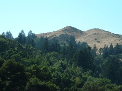
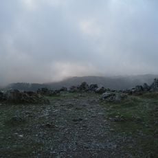
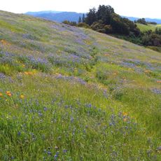
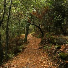
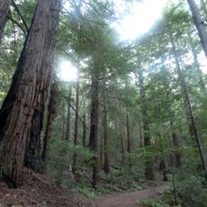
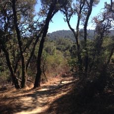
Windy Hill Open Space Preserve is a protected area in San Mateo County covering roughly 1,400 acres (570 hectares) with rolling grassland ridges, coastal redwood forests, Douglas fir groves, and oak woodlands. The landscape sits along the Bay Area Ridge Trail and showcases the natural transition between different forest types across its terrain.

The preserve was established in 1980 by the Midpeninsula Regional Open Space District through two major land purchases. These early acquisitions secured most of the land now protected in the preserve.

The preserve functions as a northeast-facing location for paragliding enthusiasts, with access managed by the Wings of Rogallo club through the United States Hang Gliding Association.

The preserve opens from before dawn until after dusk each day and offers multiple entry points with parking facilities. The main access points are located at Spring Ridge and Skyline Boulevard entrances.

The Anniversary Trail extends 0.6 miles between two parking areas, providing views of both the San Francisco Bay and the Pacific Ocean from the same vantage point.

The community of curious travelers

AroundUs brings together thousands of curated places, local tips, and hidden gems, enriched daily by 60,000 contributors worldwide.

Start exploring
Location
GPS coordinates
37.36270,-122.22400
Latest update
December 11, 2025 11:05
Around this place
Jackling House
United States of America

Jackling House

6.7 km
Center for Advanced Study in the Behavioral Sciences
United States of America

Center for Advanced Study in the Behavioral Sciences

7.5 km
Hanna–Honeycomb House
United States of America

Hanna–Honeycomb House

8 km
Lou Henry and Herbert Hoover House
United States of America

Lou Henry and Herbert Hoover House

7.8 km
Black Mountain
United States of America

Black Mountain

8.4 km
Arastradero Preserve
United States of America

Arastradero Preserve

5.1 km
Searsville Dam
United States of America

Searsville Dam

5.1 km
Frenchman's Tower
United States of America

Frenchman's Tower

6.6 km
Braun Music Center
United States of America

Braun Music Center

8.4 km
Stanford Fire Truck House
United States of America

Stanford Fire Truck House

8.3 km
Green Earth Sciences Research Building
United States of America

Green Earth Sciences Research Building

8.4 km
Folger Estate Stable Historic District
United States of America

Folger Estate Stable Historic District

5.9 km
Our Lady of the Wayside Church
United States of America

Our Lady of the Wayside Church

2.5 km
Russian Ridge Open Space Preserve
United States of America

Russian Ridge Open Space Preserve

4.9 km
United States of America

Old Union Fountain

8.4 km
Palo Alto Stock Farm Horse Barn
United States of America

Palo Alto Stock Farm Horse Barn

7.8 km
Los Trancos Open Space Preserve
United States of America

Los Trancos Open Space Preserve

5.7 km
White Memorial Fountain
United States of America

White Memorial Fountain

8.4 km
Roble Hall
United States of America

Roble Hall

8.1 km
Foothill Observatory
United States of America

Foothill Observatory

8.1 km
Sam McDonald County Park
United States of America

Sam McDonald County Park

8.2 km
Thornewood Open Space Preserve
United States of America

Thornewood Open Space Preserve

4.4 km
Stanford Dish
United States of America

Stanford Dish

6.5 km
MacFarland House
United States of America

MacFarland House

7.8 km
Portola Valley School
United States of America

Portola Valley School

2.2 km
Wilcox Solar Observatory
United States of America

Wilcox Solar Observatory

7.2 km
Denning House
United States of America

Denning House

8.1 km
Portola Valley Library
United States of America

Portola Valley Library

2.2 km
Show the full map
Reviews
Share your experience

No review yet

Discussions
Start a discussion...

No discussion yet

« Windy Hill Open Space Preserve - Protected natural area in San Mateo County, California » is provided by Around Us (aroundus.com). Images and texts are derived from Wikimedia project under a Creative Commons license. You are allowed to copy, distribute, and modify copies of this page, under the conditions set by the license, as long as this note is clearly visible.

Discover hidden gems everywhere you go!

From secret cafés to breathtaking viewpoints, skip the crowded tourist spots and find places that match your style. Our app makes it easy with voice search, smart filtering, route optimization, and insider tips from travelers worldwide. Download now for the complete mobile experience.

Around Us App Screenshot

A unique approach to discovering new places

Le Figaro

All the places worth exploring

France Info

A tailor-made excursion in just a few clicks

20 Minutes

Around Us
Travel Guide & Maps
Download

Send to your phone

QR Code
1

Open the camera app on your mobile.

2

Point at the QR code with your camera. A notification will appear.

3

Tap the notification to open the link.