Illinois Central Missouri River Bridge

Log in to your account

AroundUs is a community-driven map of interesting places, built by curious explorers like you. It grows with every review, story, and photo you share.
Connect to save your favorite spots, contribute locations, and create personalized routes.
Continue with Google
Continue with Apple
Continue with X
Continue with Facebook
Continue with email
By continuing, you accept our Terms and Conditions and our Privacy Policy
Create an account

Illinois Central Missouri River Bridge

Add to collection
Map
Suggest a change
Share

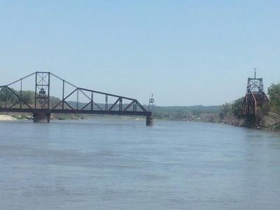
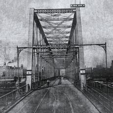
Illinois Central Missouri River Bridge, Railway swing bridge between Pottawattamie County and Douglas County, United States.

The Illinois Central Missouri River Bridge is a railway swing bridge that spans the Missouri River, connecting Council Bluffs in Iowa with Omaha in Nebraska through two major structural spans. The crossing combines wrought iron elements on the Iowa side with steel construction on the Nebraska side.

The bridge was originally built in 1893 and underwent major reconstruction between 1904 and 1908 to strengthen its design. It operated as a primary rail corridor for passenger and freight traffic until operations stopped in 1980.

The bridge connects the two river towns visually and historically, serving as a landmark that marks the boundary between two states. The structure itself tells the story of how railroads once shaped the relationship between these neighboring communities.

The bridge is accessible on foot and by bicycle from both sides of the river, making it easy to explore from either town. The Iowa section remains open to allow river traffic to pass through, which is an important detail when visiting.

The Iowa half of the bridge remains permanently open to allow river traffic to pass, while the Nebraska side stays fixed in place. This makes it a working example of how historical infrastructure continues to serve contemporary river transportation needs.

Location: Pottawattamie County

Location: Douglas County

Official opening: 1903

GPS coordinates: 41.27810,-95.89110

Latest update: December 12, 2025 09:03

Photos
Around this place
CHI Health Center Omaha
United States of America

CHI Health Center Omaha

3.5 km
Bob Kerrey Pedestrian Bridge
United States of America

Bob Kerrey Pedestrian Bridge

3 km
Jobbers Canyon Historic District
United States of America

Jobbers Canyon Historic District

3.9 km
USS Hazard
United States of America

USS Hazard

893 m
USS Marlin
United States of America

USS Marlin

862 m
Heartland of America Park
United States of America

Heartland of America Park

3.7 km
Harrah's Council Bluffs
United States of America

Harrah's Council Bluffs

3.6 km
Union Pacific Missouri River Bridge
United States of America

Union Pacific Missouri River Bridge

3.8 km
Freedom Park
United States of America

Freedom Park

882 m
Ak-Sar-Ben Bridge
United States of America

Ak-Sar-Ben Bridge

3.2 km
Slowdown
United States of America

Slowdown

3.8 km
Film Streams
United States of America

Film Streams

3.9 km
Ruth Anne Dodge Memorial
United States of America

Ruth Anne Dodge Memorial

3.7 km
Lewis and Clark Landing
United States of America

Lewis and Clark Landing

3.3 km
United States of America

Union Pacific Railroad Omaha Shops Facility

3.5 km
The Sherman
United States of America

The Sherman

3.9 km
RiverFront Place Condos
United States of America

RiverFront Place Condos

3.1 km
B'nai Israel Synagogue
United States of America

B'nai Israel Synagogue

3.6 km
Kirschbraun and Sons Creamery, Inc.
United States of America

Kirschbraun and Sons Creamery, Inc.

3.7 km
The Margaret
United States of America

The Margaret

3.8 km
State Savings Bank
United States of America

State Savings Bank

3.9 km
John J. and Agnes Shea House
United States of America

John J. and Agnes Shea House

3.7 km
Lincoln-Fairview Historic District
United States of America

Lincoln-Fairview Historic District

3.9 km
Nicholas Street Historic District
United States of America

Nicholas Street Historic District

3.6 km
Freedom Park
United States of America

Freedom Park

692 m
Old City Hall
United States of America

Old City Hall

3.8 km
Kiewit Luminarium
United States of America

Kiewit Luminarium

3.3 km
River City Star
United States of America

River City Star

2.4 km
Show the full map
Reviews

Visited this place? Tap the stars to rate it and share your experience / photos with the community! Try now! You can cancel it anytime.

« Illinois Central Missouri River Bridge - Railway swing bridge between Pottawattamie County and Douglas County, United States » is provided by Around Us (aroundus.com). Images and texts are derived from Wikimedia project under a Creative Commons license. You are allowed to copy, distribute, and modify copies of this page, under the conditions set by the license, as long as this note is clearly visible.

Discover hidden gems everywhere you go!

From secret cafés to breathtaking viewpoints, skip the crowded tourist spots and find places that match your style. Our app makes it easy with voice search, smart filtering, route optimization, and insider tips from travelers worldwide. Download now for the complete mobile experience.

Around Us App Screenshot

A unique approach to discovering new places

Le Figaro

All the places worth exploring

France Info

A tailor-made excursion in just a few clicks

20 Minutes