Enable Location

We need your location to show you interesting places around you

Discover nearby places

Find interesting locations and hidden gems around you

Precise directions

Get accurate directions and distances to places

Your location is never shared with other users. It's only used when you tap the location button.

Log in to your account

Start exploring — it's free

Trusted by travelers worldwide

Continue with Google
Continue with Apple
or

We will send you a code to connect

By continuing, you accept our Terms and Conditions and our Privacy Policy

Check your inbox

We've sent a pincode in your inbox. Please enter the code below.

Chauga Mound

Chauga Mound, Archaeological site in Oconee County, South Carolina, US.

Description

Chauga Mound is an earthen platform mound approximately 115 feet (35 meters) in diameter and 12 feet (3.6 meters) tall, located near the northern bank of the Tugaloo River in Oconee County. The structure features a flattened top and was built up in layers over time to create a ceremonial platform.

History

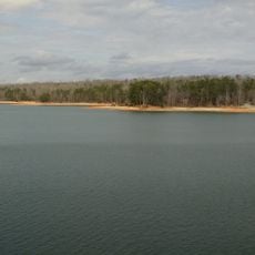
This mound was built in the 12th century by people of the South Appalachian Mississippian culture and saw four periods of occupation and use. After Hartwell Dam was completed in 1962, the site became submerged beneath Lake Hartwell.

Culture

This site served as a gathering place for the South Appalachian Mississippian people, where ceremonies took place and valuable items like copper plates were exchanged or displayed. The presence of shell ornaments and tools suggests connections between distant communities.

Practical

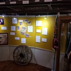
The site is now underwater as part of Lake Hartwell, making it inaccessible for direct visits or on-site exploration. Information about this place is available in regional museums and research institutions that hold artifacts from earlier excavations.

Did you know?

Researchers identified ten distinct construction phases of this mound, with each stage adding new layers that modified its shape and size. This pattern reveals that the site was continuously rebuilt and redesigned by successive generations of builders.

Location
GPS coordinates
34.60850,-83.16680
Latest update
December 12, 2025 07:58

AroundUs brings together thousands of curated places, local tips, and hidden gems, enriched daily by 60,000 contributors worldwide. Discover all places nearby (South Carolina).

Around this place
Currahee Mountain
United States of America

Currahee Mountain

21.1 km
Tallulah Gorge State Park
United States of America

Tallulah Gorge State Park

25.5 km
Toccoa Falls
United States of America

Toccoa Falls

17.8 km
Oconee State Park
United States of America

Oconee State Park

29.3 km
Issaqueena Falls
United States of America

Issaqueena Falls

22.5 km
United States of America

Bull Sluice

26.3 km
Travelers Rest
United States of America

Travelers Rest

6.7 km
Dick's Creek Falls
United States of America

Dick's Creek Falls

29.7 km
Lake Hartwell State Park
United States of America

Lake Hartwell State Park

17.7 km
Caledonia Cascade
United States of America

Caledonia Cascade

25.4 km
Ram Cat Alley Historic District
United States of America

Ram Cat Alley Historic District

21.4 km
St. John's Lutheran Church
United States of America

St. John's Lutheran Church

19.6 km
McPhail Angus Farm
United States of America

McPhail Angus Farm

21.6 km
Oconee County Cage
United States of America

Oconee County Cage

19.6 km
Stephens County Courthouse
United States of America

Stephens County Courthouse

15.4 km
Faith Cabin Library at Seneca Junior College
United States of America

Faith Cabin Library at Seneca Junior College

20.6 km
Seneca Historic District (Seneca, South Carolina)
United States of America

Seneca Historic District (Seneca, South Carolina)

21 km
Keil Farm
United States of America

Keil Farm

17.1 km
James B. Simmons House
United States of America

James B. Simmons House

15.4 km
Retreat Rosenwald School
United States of America

Retreat Rosenwald School

10.1 km
Lavonia-Carnegie Library
United States of America

Lavonia-Carnegie Library

20.2 km
Oconee County Courthouse
United States of America

Oconee County Courthouse

19.6 km
Jarrett-Hayes House
United States of America

Jarrett-Hayes House

8.7 km
Franklin County Courthouse
United States of America

Franklin County Courthouse

27.3 km
Oconee History Museum
United States of America

Oconee History Museum

19.6 km
Oconee Station State Historic Site
United States of America

Oconee Station State Historic Site

27.9 km
Currahee Military Museum
United States of America

Currahee Military Museum

15.5 km
Oconee State Park Historic District
United States of America

Oconee State Park Historic District

29.2 km
Show the full map
« Chauga Mound - Archaeological site in Oconee County, South Carolina, US » is provided by Around Us (aroundus.com). Images and texts are derived from Wikimedia project under a Creative Commons license. You are allowed to copy, distribute, and modify copies of this page, under the conditions set by the license, as long as this note is clearly visible.

Discover hidden gems everywhere you go!

From secret cafés to breathtaking viewpoints, skip the crowded tourist spots and find places that match your style. Our app makes it easy with voice search, smart filtering, route optimization, and insider tips from travelers worldwide. Download now for the complete mobile experience.

Around Us App Screenshot

A unique approach to discovering new places

Le Figaro

All the places worth exploring

France Info

A tailor-made excursion in just a few clicks

20 Minutes

Around Us
Travel Guide & Maps
Download

Send to your phone

QR Code
1

Open the camera app on your mobile.

2

Point at the QR code with your camera. A notification will appear.

3

Tap the notification to open the link.