Enable Location

We need your location to show you interesting places around you

Discover nearby places

Find interesting locations and hidden gems around you

Precise directions

Get accurate directions and distances to places

Your location is never shared with other users. It's only used when you tap the location button.

Brooklyn Heights Promenade

Log in to your account

Start exploring — it's free

Trusted by 61,997 travelers worldwide

Continue with Google
Continue with Apple
or

We will send you a code to connect

By continuing, you accept our Terms and Conditions and our Privacy Policy

Check your inbox

We've sent a pincode in your inbox. Please enter the code below.

Brooklyn Heights Promenade

Brooklyn Heights Promenade, Elevated walkway in Brooklyn Heights, United States

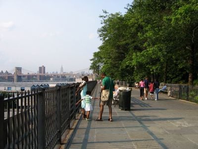
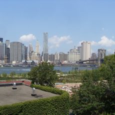
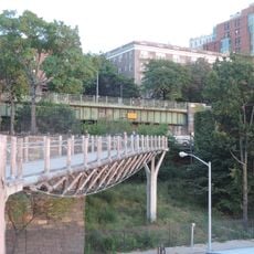
Brooklyn Heights Promenade is an elevated pedestrian path along the East River in the neighborhood of the same name, stretching about 1,826 feet (557 meters). From here, you look directly across at Manhattan's skyscrapers, the harbor, and the Brooklyn Bridge.

The path was built in the early 1950s after residents fought a plan to run an expressway through the middle of the neighborhood. The city eventually moved the route beneath the walkway, creating a public space above the traffic lanes.

The walkway takes its name from the historic neighborhood perched on a bluff above the water, once home to dockworkers and merchants. Locals come here to jog, rest on benches, or watch the sunset behind the skyline.

You enter the path through several side streets, including Remsen Street, Montague Street, and Clark Street, which lead up from the neighborhood. The walk is flat and wide enough for strollers or wheelchairs, and it's best visited in the late afternoon for the light.

The structure rests on three stacked levels, with pedestrians walking on top and two stories of car traffic running underneath. This design made it possible to hide a noisy expressway while creating a quiet public space.

The community of curious travelers

AroundUs brings together thousands of curated places, local tips, and hidden gems, enriched daily by 60,000 contributors worldwide.

Start exploring
Location
GPS coordinates
40.69750,-73.99730
Latest update
December 5, 2025 22:29
Around this place
Brooklyn Bridge Park
United States of America

Brooklyn Bridge Park

93 m
Brooklyn Borough Hall
United States of America

Brooklyn Borough Hall

792 m
Jane's Carousel
United States of America

Jane's Carousel

875 m
Cadman Plaza
United States of America

Cadman Plaza

584 m
St. Ann's Warehouse
United States of America

St. Ann's Warehouse

758 m
120 Wall Street
United States of America

120 Wall Street

1.1 km
Squibb Park Bridge
United States of America

Squibb Park Bridge

409 m
Center for Brooklyn History
United States of America

Center for Brooklyn History

487 m
1 Clinton Street
United States of America

1 Clinton Street

540 m
Theodore Roosevelt Federal Courthouse
United States of America

Theodore Roosevelt Federal Courthouse

660 m
Herman Behr Mansion
United States of America

Herman Behr Mansion

351 m
Federal Building and Post Office
United States of America

Federal Building and Post Office

688 m
Our Lady of Lebanon Maronite Cathedral
United States of America

Our Lady of Lebanon Maronite Cathedral

448 m
Eagle Warehouse & Storage Company
United States of America

Eagle Warehouse & Storage Company

619 m
Henry Ward Beecher Monument
United States of America

Henry Ward Beecher Monument

674 m
75 Livingston Street
United States of America

75 Livingston Street

787 m
Brooklyn Trust Company Building
United States of America

Brooklyn Trust Company Building

547 m
Brooklyn War Memorial
United States of America

Brooklyn War Memorial

560 m
Crescent Athletic Club House
United States of America

Crescent Athletic Club House

501 m
First Unitarian Congregational Society
United States of America

First Unitarian Congregational Society

452 m
Brooklyn Savings Bank
United States of America

Brooklyn Savings Bank

482 m
First Presbyterian Church
United States of America

First Presbyterian Church

350 m
Montague-Court Building
United States of America

Montague-Court Building

693 m
Business & Career Library
United States of America

Business & Career Library

545 m
Statue of Christopher Columbus
United States of America

Statue of Christopher Columbus

740 m
Thomas Jefferson Association Building
United States of America

Thomas Jefferson Association Building

721 m
Brooklyn Historical Society Building
United States of America

Brooklyn Historical Society Building

482 m
Fulton Ferry District
United States of America

Fulton Ferry District

765 m
Show the full map
« Brooklyn Heights Promenade - Elevated walkway in Brooklyn Heights, United States » is provided by Around Us (aroundus.com). Images and texts are derived from Wikimedia project under a Creative Commons license. You are allowed to copy, distribute, and modify copies of this page, under the conditions set by the license, as long as this note is clearly visible.

Discover hidden gems everywhere you go!

From secret cafés to breathtaking viewpoints, skip the crowded tourist spots and find places that match your style. Our app makes it easy with voice search, smart filtering, route optimization, and insider tips from travelers worldwide. Download now for the complete mobile experience.

Around Us App Screenshot

A unique approach to discovering new places

Le Figaro

All the places worth exploring

France Info

A tailor-made excursion in just a few clicks

20 Minutes

Around Us
Travel Guide & Maps
Download

Send to your phone

QR Code
1

Open the camera app on your mobile.

2

Point at the QR code with your camera. A notification will appear.

3

Tap the notification to open the link.