Enable Location

We need your location to show you interesting places around you

Discover nearby places

Find interesting locations and hidden gems around you

Precise directions

Get accurate directions and distances to places

Your location is never shared with other users. It's only used when you tap the location button.

Mount Tom State Park

Log in to your account

Start exploring — it's free

Trusted by 62,957 travelers worldwide

Continue with Google
Continue with Apple
or

We will send you a code to connect

By continuing, you accept our Terms and Conditions and our Privacy Policy

Check your inbox

We've sent a pincode in your inbox. Please enter the code below.

Mount Tom State Park
Discussion Reviews 1 Photos 1 Collections
3.6k Popularity

Mount Tom State Park, State park in Litchfield, United States.

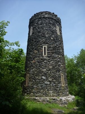
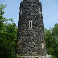
Mount Tom State Park is a nature preserve of roughly 231 acres in Connecticut, centered around Mount Tom Pond. A black gneiss tower sits at the park's summit and offers views toward Massachusetts and Long Island Sound.

The park was established in 1915 after Charles H. Senff donated the land in 1911, requiring that an observation tower remain at the summit. The black gneiss tower was designed and built by Alfred M. Turner in 1921.

The stone tower shows how people in the early 20th century chose to develop public recreation areas in Connecticut. Visitors today gather at the summit to take in the views and understand how communities valued outdoor access.

Visitors reach the tower via a roughly 1-mile (1.6 km) trail that climbs about 500 feet (152 m) in elevation. Parking is available near Mount Tom Pond.

The park displays black gneiss and schist with visible mineral bands of quartz and hornblende throughout its landscape. These rock formations are visible along the trails and reveal the geological story of the region.

The community of curious travelers

AroundUs brings together thousands of curated places, local tips, and hidden gems, enriched daily by 60,000 contributors worldwide.

Start exploring
Location
Location
Location
Inception
1915
Elevation above the sea
299 m
GPS coordinates
41.69250,-73.27944
Latest update
December 6, 2025 17:43
Nature sites and historic places in Connecticut

Connecticut combines different landscapes from the coast to the mountains with a range of historic sites. The region includes state parks with waterfalls like Kent Falls and Wadsworth Falls, extensive forested areas, and conservation lands. Visitors can hike through White Memorial Conservation...

Around this place
Rye House
United States of America

Rye House

3.2 km
Bellamy-Ferriday House and Garden
United States of America

Bellamy-Ferriday House and Garden

7.9 km
Stillman House
United States of America

Stillman House

10.2 km
Garbage Museum
United States of America

Garbage Museum

10.4 km
Topsmead
United States of America

Topsmead

11.6 km
Milton Center Historic District
United States of America

Milton Center Historic District

8.4 km
Above All State Park
United States of America

Above All State Park

7.2 km
Oliver Wolcott House
United States of America

Oliver Wolcott House

9.5 km
White Memorial Foundation
United States of America

White Memorial Foundation

6 km
Litchfield Historic District
United States of America

Litchfield Historic District

9.6 km
First Congregational Church of Litchfield
United States of America

First Congregational Church of Litchfield

9.8 km
Hunt Hill Farm
United States of America

Hunt Hill Farm

10.5 km
Mount Bushnell State Park
United States of America

Mount Bushnell State Park

6.9 km
Christ Episcopal Church
United States of America

Christ Episcopal Church

8.4 km
The Hollister Homestead
United States of America

The Hollister Homestead

8.3 km
Trinity Church
United States of America

Trinity Church

8.7 km
Bethlehem Green Historic District
United States of America

Bethlehem Green Historic District

8.5 km
New Preston Hill Historic District
United States of America

New Preston Hill Historic District

7.9 km
Capt. Philo Beardsley House
United States of America

Capt. Philo Beardsley House

9.4 km
Henry B. Bissell House
United States of America

Henry B. Bissell House

6.2 km
St. Andrew's Episcopal Church
United States of America

St. Andrew's Episcopal Church

8.2 km
Washington Green Historic District
United States of America

Washington Green Historic District

7.7 km
Calhoun-Ives Historic District
United States of America

Calhoun-Ives Historic District

5.8 km
David Welch House
United States of America

David Welch House

8.7 km
Caleb Martin House
United States of America

Caleb Martin House

8.5 km
Town Hall and District School No. 6
United States of America

Town Hall and District School No. 6

6.7 km
Lake Waramaug State Park
United States of America

Lake Waramaug State Park

8.7 km
Mount Tom Tower
United States of America

Mount Tom Tower

510 m
Show the full map
Reviews
Share your experience

No review yet

Discussions
Start a discussion...

No discussion yet

« Mount Tom State Park - State park in Litchfield, United States » is provided by Around Us (aroundus.com). Images and texts are derived from Wikimedia project under a Creative Commons license. You are allowed to copy, distribute, and modify copies of this page, under the conditions set by the license, as long as this note is clearly visible.

Discover hidden gems everywhere you go!

From secret cafés to breathtaking viewpoints, skip the crowded tourist spots and find places that match your style. Our app makes it easy with voice search, smart filtering, route optimization, and insider tips from travelers worldwide. Download now for the complete mobile experience.

Around Us App Screenshot

A unique approach to discovering new places

Le Figaro

All the places worth exploring

France Info

A tailor-made excursion in just a few clicks

20 Minutes

Around Us
Travel Guide & Maps
Download

Send to your phone

QR Code
1

Open the camera app on your mobile.

2

Point at the QR code with your camera. A notification will appear.

3

Tap the notification to open the link.