Chest opened
+${chestReward.xp} XP
Explorer
NOUVEAU ×${chestReward.collectible.quantity}
tapez pour fermer
Chest locked

Open chests in the app

Around Us is built for your phone — chests unlock when you walk, explore and capture nearby places.

Enable Location

We need your location to show you interesting places around you

Discover nearby places

Find interesting locations and hidden gems around you

Precise directions

Get accurate directions and distances to places

Your location is never shared with other users. It's only used when you tap the location button.

Freedom High School

Log in to your account

Start exploring — it's free

Trusted by 72,890 travelers worldwide

Continue with Google
Continue with Apple
or

We will send you a code to connect

By continuing, you accept our Terms and Conditions and our Privacy Policy

Check your inbox

We've sent a pincode in your inbox. Please enter the code below.

Freedom High School
Discussion Reviews 1 Photos
20k Popularity

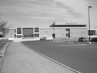
Freedom High School, public high school in Bethlehem, Pennsylvania, United States

Freedom High School is a large school facility in Bethlehem Township serving grades 9 through 12 since 1967. The campus includes classrooms, science labs, arts spaces, a gymnasium, fitness room, and athletic fields spread across the grounds on Chester Avenue.

The school opened in 1967 and has been part of the Bethlehem community for over 50 years. In 2006, new classrooms and a modern gymnasium were added to meet the school's expanding needs.

The school's Patriot mascot and black-and-gold colors connect to American independence and local pride. This identity appears in daily life through school events, sports competitions, and gatherings where students and families come together.

The school is located in a busy area on Chester Avenue and is easily accessible. Visitors should be aware that the campus is active during school hours and access may be limited to certain areas or scheduled events.

One of the school's notable alumni is Dwayne Johnson, the internationally famous actor and former professional wrestler. This connection brings the school attention in popular culture and sports circles.

The community of curious travelers

AroundUs brings together thousands of curated places, local tips, and hidden gems, enriched daily by 60,000 contributors worldwide.

Start exploring
Location
Inception
1967
Operator
Bethlehem Area School District
Address
Chester Avenue
GPS coordinates
40.66400,-75.34000
Latest update
February 16, 2026 22:00
Around this place
Nazareth Speedway
United States of America

Nazareth Speedway

7.2 km
Martin Tower
United States of America

Martin Tower

5.8 km
Bushkill Park
United States of America

Bushkill Park

8.6 km
Goodman Stadium
United States of America

Goodman Stadium

8.5 km
Stabler Arena
United States of America

Stabler Arena

9 km
Hill to Hill Bridge
United States of America

Hill to Hill Bridge

6.6 km
Central Park
United States of America

Central Park

8.3 km
Bethlehem Waterworks
United States of America

Bethlehem Waterworks

6.2 km
Historic Moravian Bethlehem Historic District
United States of America

Historic Moravian Bethlehem Historic District

6.1 km
Burnside Plantation
United States of America

Burnside Plantation

5.6 km
Pembroke Village
United States of America

Pembroke Village

4 km
Cathedral Church of the Nativity
United States of America

Cathedral Church of the Nativity

6.9 km
Whitefield House and Gray Cottage
United States of America

Whitefield House and Gray Cottage

9 km
Philip J. Fahy Memorial Bridge
United States of America

Philip J. Fahy Memorial Bridge

6.3 km
Gemeinhaus-Lewis David de Schweinitz Residence
United States of America

Gemeinhaus-Lewis David de Schweinitz Residence

6.1 km
Central Bethlehem Historic District
United States of America

Central Bethlehem Historic District

6.2 km
South Bethlehem Downtown Historic District
United States of America

South Bethlehem Downtown Historic District

6.5 km
Fountain Hill Historic District
United States of America

Fountain Hill Historic District

7.1 km
Illick's Mill
United States of America

Illick's Mill

4.3 km
Chain Bridge
United States of America

Chain Bridge

7.8 km
Lutz-Franklin School
United States of America

Lutz-Franklin School

6.6 km
Elmwood Park Historic District
United States of America

Elmwood Park Historic District

4.9 km
Daniel Steckel House
United States of America

Daniel Steckel House

8.4 km
Gristmiller's House
United States of America

Gristmiller's House

6 km
Holy Ghost Ukrainian Catholic Church
United States of America

Holy Ghost Ukrainian Catholic Church

8.8 km
National Museum of Industrial History
United States of America

National Museum of Industrial History

6.3 km
Minsi Trail Bridge
United States of America

Minsi Trail Bridge

5.4 km
Movies
United States of America

Movies

8.7 km
Show the full map
Reviews
Share your experience

No review yet

Discussions
Start a discussion...

No discussion yet

« Freedom High School - public high school in Bethlehem, Pennsylvania, United States » is provided by Around Us (aroundus.com). Images and texts are derived from Wikimedia project under a Creative Commons license. You are allowed to copy, distribute, and modify copies of this page, under the conditions set by the license, as long as this note is clearly visible.

Discover hidden gems everywhere you go!

From secret cafés to breathtaking viewpoints, skip the crowded tourist spots and find places that match your style. Our app makes it easy with voice search, smart filtering, route optimization, and insider tips from travelers worldwide. Download now for the complete mobile experience.

Around Us App Screenshot

A unique approach to discovering new places

Le Figaro

All the places worth exploring

France Info

A tailor-made excursion in just a few clicks

20 Minutes

Around Us
Travel Guide & Maps
Download

Send to your phone

QR Code
1

Open the camera app on your mobile.

2

Point at the QR code with your camera. A notification will appear.

3

Tap the notification to open the link.