Grand Portal Point, Cape in Alger County, Michigan, United States
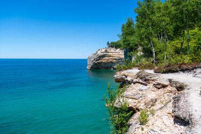
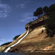
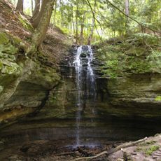
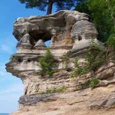
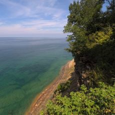
Grand Portal Point is a cape in Michigan's Upper Peninsula featuring sheer sandstone cliffs that rise directly from Lake Superior's waters. The rock walls create a bold vertical formation along the shoreline and make this location a striking feature of the region's coastal landscape.
The rock cliffs formed millions of years ago when ancient seas deposited layers of sandstone that were later shaped by glacial processes. These geological forces created the distinctive coastal formation visible at this location today.
Native American tribes of the Upper Peninsula incorporated the cliffs of Grand Portal Point into their traditional stories and used the waters for fishing.
The site is reached via a hiking trail approximately 5 kilometers from the Chapel parking area, requiring sturdy footwear for uneven terrain. Visitors should bring water and food, as facilities are limited along the route.
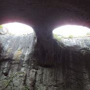
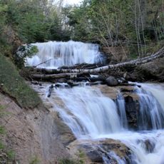
Lake Superior's waters have carved natural archways and caverns beneath the cliffs, with surfaces that shift color throughout the day due to mineral content. These hidden features remain largely unseen from shore and are often missed by visitors.
Location: Alger County
Address: Grand Portal Point, Munising Township, MI 49884, USA
GPS coordinates: 46.55000,-86.46278
Latest update: December 6, 2025 19:08
Geological forces have carved openings, arches, and caves into rock formations across continents through millions of years of erosion. Water, wind, and weathering have shaped these natural structures from various rock types, creating landmarks that reveal the Earth's ongoing transformation. The formations appear in diverse environments, from coastlines where ocean waves carve passages through limestone cliffs to desert regions where wind erosion creates openings in sandstone walls. This collection spans locations such as Durdle Door along England's Jurassic Coast, where a 200-foot (60-meter) arch rises from layers dating to the Mesozoic era. The Faraglioni Rocks off Capri reach heights of 360 feet (109 meters) and include a natural passage navigable by boat. In landlocked regions, formations like the Eyes of God in Bulgaria's Prohodna Cave display symmetrical ceiling openings where sunlight penetrates the rock. Desert sites such as Las Ventanas in Argentina's Andes showcase wind-carved arches in remote sandstone landscapes. Each location offers direct evidence of erosion processes that continue shaping these geological features, from readily accessible coastal points to isolated areas requiring significant travel to reach.
Grand Island National Recreation Area
16.1 km
Grand Island East Channel Light
16.1 km
Au Sable Light
28.3 km
Munising Falls
18.7 km
Pickle Barrel House
39 km
Miners Falls
9.9 km
Sable Falls
36.8 km
Wagner Falls Scenic Site
22.9 km
Wagner Falls
23.6 km
Scott Falls
29.1 km
Bridalveil Falls
6.5 km
Tannery Falls
19.5 km
Onota, Au Train Township, Michigan
22.2 km
Munising Front Range Light
21.4 km
Grand Island North Light
16.7 km
Grand Island Harbor Rear Range Light
21.6 km
Munising Rear Range Light
21.7 km
Alger Falls
22.5 km
Memorial Falls
19.3 km
Beaver Basin Wilderness
10.9 km
Old M-94–Au Train River Bridge
30.6 km
Schoolcraft Furnace Site
18.6 km
Paulson House
33.7 km
Lobb House
21.5 km
Grand Island Harbor Front Range Light
21.5 km
Chapel Rock
1.9 km
Munising School Public Library
21.3 km
Pictured Rocks
2.7 kmVisited this place? Tap the stars to rate it and share your experience / photos with the community! Try now! You can cancel it anytime.
Discover hidden gems everywhere you go!
From secret cafés to breathtaking viewpoints, skip the crowded tourist spots and find places that match your style. Our app makes it easy with voice search, smart filtering, route optimization, and insider tips from travelers worldwide. Download now for the complete mobile experience.
A unique approach to discovering new places❞
— Le Figaro
All the places worth exploring❞
— France Info
A tailor-made excursion in just a few clicks❞
— 20 Minutes