State Game Lands Number 97, Wildlife conservation area in Bedford County, Pennsylvania.
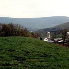
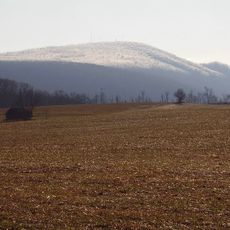
State Game Lands Number 97 is a wildlife management area located across Tussey Mountain with valleys on both sides and varying terrain. The land includes mixed forests, open meadows, and wetland areas that support diverse animal populations throughout the year.
The area was established as a managed game lands property by the Pennsylvania Game Commission in 1979. This designation created a framework for protecting wildlife populations while allowing regulated hunting activities.
Local hunters and nature enthusiasts gather at State Game Lands Number 97 during seasonal hunting periods, following long-standing Pennsylvania outdoor traditions.
Visitors who want to hunt must obtain a valid hunting license and permit from the Pennsylvania Game Commission before entering. Access to the grounds is available through several public entry points located around the mountain.
The lands support populations of predators and other wildlife including beaver, coyote, gray fox, red fox, and raccoon that thrive across different zones. This variety shows how the mountain's diverse habitats create space for many different animal species.
The community of curious travelers
AroundUs brings together thousands of curated places, local tips, and hidden gems, enriched daily by 60,000 contributors worldwide.