Enable Location

We need your location to show you interesting places around you

Discover nearby places

Find interesting locations and hidden gems around you

Precise directions

Get accurate directions and distances to places

Your location is never shared with other users. It's only used when you tap the location button.

Log in to your account

Start exploring — it's free

Trusted by 65,244 travelers worldwide

Continue with Google
Continue with Apple
or

We will send you a code to connect

By continuing, you accept our Terms and Conditions and our Privacy Policy

Check your inbox

We've sent a pincode in your inbox. Please enter the code below.

Potawatomi State Park
Discussion Reviews Photo
4.8k Popularity

Potawatomi State Park, State park in Door County, United States.

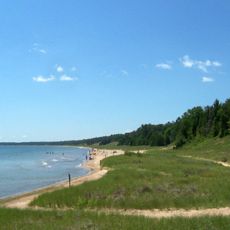
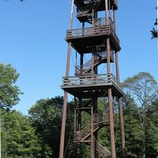
Potawatomi State Park is a Wisconsin state park located in Door County, along the western shore of Sturgeon Bay where it opens into Green Bay. The park covers a mix of forest, wetland, and shoreline, with trails, a campground, boat launches, and fishing spots available throughout.

A federal reservation was established on this land in 1837, though it did not last long before the area changed hands. The site became a state park in 1928, and traces of a quarry that operated here from 1834 onward can still be found across the terrain.

The park takes its name from the Potawatomi people, who lived and traveled through this part of Wisconsin for generations. Walking along the shoreline or through the woods, visitors move through the same land those communities once called home.

Trails are well marked and the main areas, including the shoreline, campground, and boat launches, are easy to find from the parking lots. An annual or daily Wisconsin state park pass is required to enter, and passes can be purchased on arrival.

The park serves as the eastern terminus of the Ice Age National Scenic Trail, a long-distance route that follows the edge of the last glacier across Wisconsin. Starting here means the first steps of that journey are taken right along the Sturgeon Bay shoreline.

The community of curious travelers

AroundUs brings together thousands of curated places, local tips, and hidden gems, enriched daily by 60,000 contributors worldwide.

Start exploring
Location
Inception
1928
GPS coordinates
44.86440,-87.41500
Latest update
March 3, 2026 08:13
Around this place
Whitefish Dunes State Park
United States of America

Whitefish Dunes State Park

17.7 km
SS Lakeland
United States of America

SS Lakeland

19.7 km
Green Island Light
United States of America

Green Island Light

22.2 km
Sturgeon Bay Bridge
United States of America

Sturgeon Bay Bridge

4.5 km
Sturgeon Bay Canal North Pierhead Light
United States of America

Sturgeon Bay Canal North Pierhead Light

11.6 km
Sturgeon Bay Canal Light
United States of America

Sturgeon Bay Canal Light

11.1 km
Sherwood Point Light
United States of America

Sherwood Point Light

3.5 km
Door County Maritime Museum
United States of America

Door County Maritime Museum

4.6 km
Algoma Pierhead Light
United States of America

Algoma Pierhead Light

28.7 km
Bayshore Blufflands State Natural Area
United States of America

Bayshore Blufflands State Natural Area

8.1 km
Coast Guard Station Sturgeon Bay
United States of America

Coast Guard Station Sturgeon Bay

11.2 km
Cupola House
United States of America

Cupola House

23.4 km
Peshtigo Reef Light
United States of America

Peshtigo Reef Light

16.5 km
St Agnes-by-the-Lake Episcopal Church
United States of America

St Agnes-by-the-Lake Episcopal Church

28.9 km
Ahnapee Brewery
United States of America

Ahnapee Brewery

28.4 km
L. A. Larson & Co. Store
United States of America

L. A. Larson & Co. Store

4.9 km
Carnegie Free Library
United States of America

Carnegie Free Library

4.5 km
Teweles and Brandeis Grain Elevator
United States of America

Teweles and Brandeis Grain Elevator

4.7 km
Third Avenue Historic District
United States of America

Third Avenue Historic District

4.5 km
Melvin W. and Mary Perry House
United States of America

Melvin W. and Mary Perry House

28.6 km
Art Dettman Fishing Shanty
United States of America

Art Dettman Fishing Shanty

28.4 km
Louis Vangindertahlen House
United States of America

Louis Vangindertahlen House

18.7 km
J.B. Bouche House
United States of America

J.B. Bouche House

21.8 km
Joseph Monfils Farmstead
United States of America

Joseph Monfils Farmstead

18.9 km
Joachine J. Falque House
United States of America

Joachine J. Falque House

22.7 km
Potawatomi State Park Observation Tower
United States of America

Potawatomi State Park Observation Tower

1.7 km
Door County Historical Museum
United States of America

Door County Historical Museum

4.5 km
Menekaunee, Wisconsin
United States of America

Menekaunee, Wisconsin

28.7 km
Show the full map
Reviews
Share your experience

No review yet

Discussions
Start a discussion...

No discussion yet

« Potawatomi State Park - State park in Door County, United States » is provided by Around Us (aroundus.com). Images and texts are derived from Wikimedia project under a Creative Commons license. You are allowed to copy, distribute, and modify copies of this page, under the conditions set by the license, as long as this note is clearly visible.

Discover hidden gems everywhere you go!

From secret cafés to breathtaking viewpoints, skip the crowded tourist spots and find places that match your style. Our app makes it easy with voice search, smart filtering, route optimization, and insider tips from travelers worldwide. Download now for the complete mobile experience.

Around Us App Screenshot

A unique approach to discovering new places

Le Figaro

All the places worth exploring

France Info

A tailor-made excursion in just a few clicks

20 Minutes

Around Us
Travel Guide & Maps
Download

Send to your phone

QR Code
1

Open the camera app on your mobile.

2

Point at the QR code with your camera. A notification will appear.

3

Tap the notification to open the link.