Enable Location

We need your location to show you interesting places around you

Discover nearby places

Find interesting locations and hidden gems around you

Precise directions

Get accurate directions and distances to places

Your location is never shared with other users. It's only used when you tap the location button.

Sturgeon Bay Bridge

Log in to your account

Start exploring — it's free

Trusted by 65,153 travelers worldwide

Continue with Google
Continue with Apple
or

We will send you a code to connect

By continuing, you accept our Terms and Conditions and our Privacy Policy

Check your inbox

We've sent a pincode in your inbox. Please enter the code below.

Discussion Reviews 1 Photos
3.6k Popularity

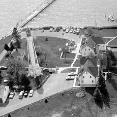
Sturgeon Bay Bridge, Historic bascule bridge in Sturgeon Bay, United States.

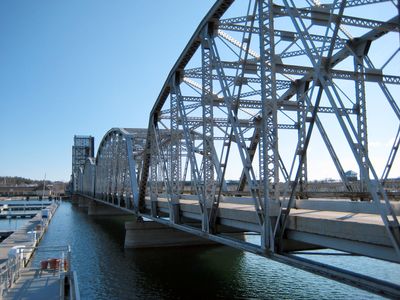
The Sturgeon Bay Bridge is a double-leaf rolling bascule bridge that crosses the shipping channel in Sturgeon Bay, Wisconsin. The roadway sits on Warren and Parker through-trusses, which form the visible steel framework on both sides of the crossing.

The bridge was completed in 1931 by the Chicago engineering firm Keller & Harrington, replacing earlier crossings that required a toll. It was later added to the National Register of Historic Places in recognition of its place in early 20th-century engineering history.

The bridge is part of daily life in Sturgeon Bay, used by locals to cross between the two sides of the city. When a boat needs to pass, traffic stops and the two halves of the roadway tilt upward, which draws the attention of anyone nearby.

Both pedestrians and cyclists can cross the bridge, though caution is needed when the lift mechanism is active and traffic is stopped. Drivers with tall vehicles should check the clearance markers at the center and sides before proceeding.

This is the only operating Scherzer-type double-leaf rolling lift bridge with overhead trusses in the state of Wisconsin. This type of bridge was once found in more places across the country but is rarely built today, making this one a surviving example of the design.

The community of curious travelers

AroundUs brings together thousands of curated places, local tips, and hidden gems, enriched daily by 60,000 contributors worldwide.

Start exploring
Location
Official opening
1931
GPS coordinates
44.83194,-87.38111
Latest update
March 3, 2026 14:00
Around this place
Whitefish Dunes State Park
United States of America

Whitefish Dunes State Park

17.1 km
United States of America

Potawatomi State Park

4.5 km
SS Lakeland
United States of America

SS Lakeland

15.9 km
Green Island Light
United States of America

Green Island Light

26.5 km
Sturgeon Bay Canal North Pierhead Light
United States of America

Sturgeon Bay Canal North Pierhead Light

7.2 km
Sherwood Point Light
United States of America

Sherwood Point Light

8 km
Sturgeon Bay Canal Light
United States of America

Sturgeon Bay Canal Light

6.8 km
Door County Maritime Museum
United States of America

Door County Maritime Museum

231 m
Algoma Pierhead Light
United States of America

Algoma Pierhead Light

25.4 km
Kangaroo Lake State Natural Area
United States of America

Kangaroo Lake State Natural Area

30 km
Bayshore Blufflands State Natural Area
United States of America

Bayshore Blufflands State Natural Area

11.5 km
Coast Guard Station Sturgeon Bay
United States of America

Coast Guard Station Sturgeon Bay

6.8 km
Cupola House
United States of America

Cupola House

25.7 km
Peshtigo Reef Light
United States of America

Peshtigo Reef Light

20.9 km
St Agnes-by-the-Lake Episcopal Church
United States of America

St Agnes-by-the-Lake Episcopal Church

25.6 km
Ahnapee Brewery
United States of America

Ahnapee Brewery

25.1 km
L. A. Larson & Co. Store
United States of America

L. A. Larson & Co. Store

592 m
Carnegie Free Library
United States of America

Carnegie Free Library

540 m
Teweles and Brandeis Grain Elevator
United States of America

Teweles and Brandeis Grain Elevator

365 m
Third Avenue Historic District
United States of America

Third Avenue Historic District

478 m
Melvin W. and Mary Perry House
United States of America

Melvin W. and Mary Perry House

25.3 km
Art Dettman Fishing Shanty
United States of America

Art Dettman Fishing Shanty

25.1 km
J.B. Bouche House
United States of America

J.B. Bouche House

21.9 km
Louis Vangindertahlen House
United States of America

Louis Vangindertahlen House

18.5 km
Joseph Monfils Farmstead
United States of America

Joseph Monfils Farmstead

18.7 km
Joachine J. Falque House
United States of America

Joachine J. Falque House

22.6 km
Potawatomi State Park Observation Tower
United States of America

Potawatomi State Park Observation Tower

6.2 km
Door County Historical Museum
United States of America

Door County Historical Museum

598 m
Show the full map
Reviews
Share your experience

No review yet

Discussions
Start a discussion...

No discussion yet

« Sturgeon Bay Bridge - Historic bascule bridge in Sturgeon Bay, United States » is provided by Around Us (aroundus.com). Images and texts are derived from Wikimedia project under a Creative Commons license. You are allowed to copy, distribute, and modify copies of this page, under the conditions set by the license, as long as this note is clearly visible.

Discover hidden gems everywhere you go!

From secret cafés to breathtaking viewpoints, skip the crowded tourist spots and find places that match your style. Our app makes it easy with voice search, smart filtering, route optimization, and insider tips from travelers worldwide. Download now for the complete mobile experience.

Around Us App Screenshot

A unique approach to discovering new places

Le Figaro

All the places worth exploring

France Info

A tailor-made excursion in just a few clicks

20 Minutes

Around Us
Travel Guide & Maps
Download

Send to your phone

QR Code
1

Open the camera app on your mobile.

2

Point at the QR code with your camera. A notification will appear.

3

Tap the notification to open the link.