Enable Location

We need your location to show you interesting places around you

Discover nearby places

Find interesting locations and hidden gems around you

Precise directions

Get accurate directions and distances to places

Your location is never shared with other users. It's only used when you tap the location button.

Bayshore Blufflands State Natural Area

Log in to your account

Start exploring — it's free

Trusted by 61,971 travelers worldwide

Continue with Google
Continue with Apple
or

We will send you a code to connect

By continuing, you accept our Terms and Conditions and our Privacy Policy

Check your inbox

We've sent a pincode in your inbox. Please enter the code below.

Bayshore Blufflands State Natural Area

Bayshore Blufflands State Natural Area, Protected natural area near Green Bay, Wisconsin.

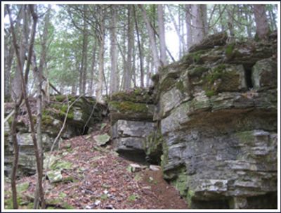
Bayshore Blufflands is a protected natural area in Wisconsin that preserves a dramatic limestone ridge rising sharply above Green Bay's surroundings. The site includes walking trails through forests of sugar maple, red oak, and white cedar that cover the slopes and plateau above the cliffs.

The state designated this area for protection in 2002 to safeguard its geological character and preserve the diverse plant and animal communities. The limestone formation itself developed over millions of years and was later shaped by water erosion into the steep bluffs seen today.

The area serves as a living laboratory where researchers study native mollusks and rare plant communities that depend on the specific geology of the bluffs. Visitors can observe how the natural conditions here support species found nowhere else in the region.

Parking areas are available at both ends of the property for access to the trail system that winds through the forested bluffs. The paths are easier to navigate in dry conditions since some sections cross steep slopes.

Natural springs flow from the base of the bluffs, creating pockets of wet habitat where rare plants like climbing fumitory and mountain maple grow. These seepage areas at the cliff foot attract plant enthusiasts looking for species found nowhere else nearby.

The community of curious travelers

AroundUs brings together thousands of curated places, local tips, and hidden gems, enriched daily by 60,000 contributors worldwide.

Start exploring
Location
Location
Inception
2002
GPS coordinates
44.93470,-87.39030
Latest update
December 14, 2025 16:47
Around this place
Whitefish Dunes State Park
United States of America

Whitefish Dunes State Park

14.7 km
United States of America

Potawatomi State Park

8.1 km
SS Lakeland
United States of America

SS Lakeland

22.7 km
Green Island Light
United States of America

Green Island Light

15.8 km
Sturgeon Bay Bridge
United States of America

Sturgeon Bay Bridge

11.5 km
Sturgeon Bay Canal North Pierhead Light
United States of America

Sturgeon Bay Canal North Pierhead Light

17.1 km
Sturgeon Bay Canal Light
United States of America

Sturgeon Bay Canal Light

16.7 km
Sherwood Point Light
United States of America

Sherwood Point Light

5.7 km
Door County Maritime Museum
United States of America

Door County Maritime Museum

11.6 km
Alexander Noble House
United States of America

Alexander Noble House

24.3 km
Kangaroo Lake State Natural Area
United States of America

Kangaroo Lake State Natural Area

22.3 km
Coast Guard Station Sturgeon Bay
United States of America

Coast Guard Station Sturgeon Bay

16.8 km
Church of the Atonement
United States of America

Church of the Atonement

24.2 km
Cupola House
United States of America

Cupola House

15.6 km
Peshtigo Reef Light
United States of America

Peshtigo Reef Light

15.1 km
L. A. Larson & Co. Store
United States of America

L. A. Larson & Co. Store

11.5 km
Menominee Opera House
United States of America

Menominee Opera House

25.1 km
First Street Historic District
United States of America

First Street Historic District

25.3 km
Carnegie Free Library
United States of America

Carnegie Free Library

11.2 km
Teweles and Brandeis Grain Elevator
United States of America

Teweles and Brandeis Grain Elevator

11.8 km
Third Avenue Historic District
United States of America

Third Avenue Historic District

11.2 km
Freeman and Jesse Thorp House and Cottages
United States of America

Freeman and Jesse Thorp House and Cottages

24.2 km
Baileys Harbor Town Hall-McArdle Library
United States of America

Baileys Harbor Town Hall-McArdle Library

25.5 km
Independent Order of Odd Fellows-Lodge No. 189 Building
United States of America

Independent Order of Odd Fellows-Lodge No. 189 Building

25.5 km
Potawatomi State Park Observation Tower
United States of America

Potawatomi State Park Observation Tower

7.1 km
Door County Historical Museum
United States of America

Door County Historical Museum

11.1 km
Menominee Pier Light
United States of America

Menominee Pier Light

23.8 km
Menekaunee, Wisconsin
United States of America

Menekaunee, Wisconsin

23.5 km
Show the full map
« Bayshore Blufflands State Natural Area - Protected natural area near Green Bay, Wisconsin » is provided by Around Us (aroundus.com). Images and texts are derived from Wikimedia project under a Creative Commons license. You are allowed to copy, distribute, and modify copies of this page, under the conditions set by the license, as long as this note is clearly visible.

Discover hidden gems everywhere you go!

From secret cafés to breathtaking viewpoints, skip the crowded tourist spots and find places that match your style. Our app makes it easy with voice search, smart filtering, route optimization, and insider tips from travelers worldwide. Download now for the complete mobile experience.

Around Us App Screenshot

A unique approach to discovering new places

Le Figaro

All the places worth exploring

France Info

A tailor-made excursion in just a few clicks

20 Minutes

Around Us
Travel Guide & Maps
Download

Send to your phone

QR Code
1

Open the camera app on your mobile.

2

Point at the QR code with your camera. A notification will appear.

3

Tap the notification to open the link.