Enable Location

We need your location to show you interesting places around you

Discover nearby places

Find interesting locations and hidden gems around you

Precise directions

Get accurate directions and distances to places

Your location is never shared with other users. It's only used when you tap the location button.

Log in to your account

Start exploring — it's free

Trusted by 61,907 travelers worldwide

Continue with Google
Continue with Apple
or

We will send you a code to connect

By continuing, you accept our Terms and Conditions and our Privacy Policy

Check your inbox

We've sent a pincode in your inbox. Please enter the code below.

Queeny Park

Queeny Park, County park in St. Louis County, Missouri, United States

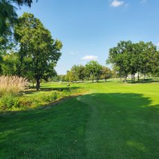
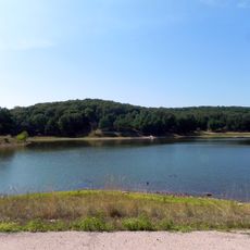
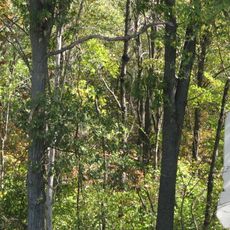
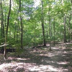
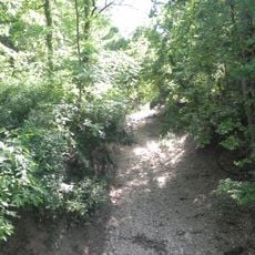
Queeny Park is a county park in St. Louis County featuring forests, prairie lands, and riparian zones spread throughout its grounds. A trail system with mixed surfaces winds through the property, connecting the various natural areas and providing access to facilities like tennis courts, picnic areas, and a dog park.

The land was once owned by Edgar M. Queeny, chairman of Monsanto, until he sold it to a realty company in 1964. The property was then transformed into a public park for community use.

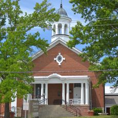
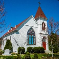
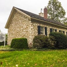
The Jarville House, built in 1854 in Greek Revival style, represents the architectural heritage visible in the park today. People visit the structure to connect with the region's past and see how early construction methods and design shaped local landmarks.

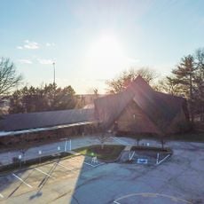
The park provides multiple entry points and parking areas near its main facilities for easy access. Visit during warmer months to enjoy the trails and outdoor spaces, or plan a trip during colder seasons if you want to use the seasonal ice rink.

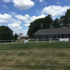
The park has dedicated spaces for equestrian activities where horses can be seen grazing in the prairie sections along the north and west boundaries. For visitors interested in riding activities or wildlife watching, these areas offer an unexpected element within an urban park setting.

The community of curious travelers

AroundUs brings together thousands of curated places, local tips, and hidden gems, enriched daily by 60,000 contributors worldwide.

Start exploring
GPS coordinates
38.61232,-90.49025
Latest update
December 12, 2025 14:26
Around this place
Bellerive Country Club
United States of America

Bellerive Country Club

5.3 km
United States of America

Kirkwood City Council shooting

8.1 km
United States of America

St. Louis County Library

7.7 km
National Museum of Transportation
United States of America

National Museum of Transportation

5.1 km
The Magic House, St. Louis Children's Museum
United States of America

The Magic House, St. Louis Children's Museum

8.5 km
Castlewood State Park
United States of America

Castlewood State Park

8.1 km
Saint Louis Abbey
United States of America

Saint Louis Abbey

3.7 km
Lone Elk County Park
United States of America

Lone Elk County Park

9.9 km
Laumeier Sculpture Park
United States of America

Laumeier Sculpture Park

9.6 km
Kraus House
United States of America

Kraus House

5.3 km
St. Louis Missouri Temple
United States of America

St. Louis Missouri Temple

3.8 km
Hindu Temple of St. Louis
United States of America

Hindu Temple of St. Louis

815 m
Butterfly House, Missouri Botanical Garden
United States of America

Butterfly House, Missouri Botanical Garden

7.4 km
Theodore A. Pappas House
United States of America

Theodore A. Pappas House

2.8 km
Cragwold
United States of America

Cragwold

7.8 km
Manchester United Methodist Church
United States of America

Manchester United Methodist Church

2.6 km
Kirkwood Public Library
United States of America

Kirkwood Public Library

8.2 km
Congregation Shaare Emeth
United States of America

Congregation Shaare Emeth

6.5 km
Barretts Tunnels
United States of America

Barretts Tunnels

5.2 km
Emmenegger Nature Park
United States of America

Emmenegger Nature Park

8.4 km
United States of America

J. Milton Turner School

9.3 km
Temple Emanuel
United States of America

Temple Emanuel

4.9 km
Old Stone Church
United States of America

Old Stone Church

5.1 km
Olive Chapel African Methodist Episcopal Church
United States of America

Olive Chapel African Methodist Episcopal Church

7.8 km
Des Peres Presbyterian Church
United States of America

Des Peres Presbyterian Church

6.2 km
Eliot Unitarian Chapel
United States of America

Eliot Unitarian Chapel

8.3 km
Possum Woods Conservation Area
United States of America

Possum Woods Conservation Area

8.8 km
Burkhardt Historic District
United States of America

Burkhardt Historic District

9.6 km
Show the full map
« Queeny Park - County park in St. Louis County, Missouri, United States » is provided by Around Us (aroundus.com). Images and texts are derived from Wikimedia project under a Creative Commons license. You are allowed to copy, distribute, and modify copies of this page, under the conditions set by the license, as long as this note is clearly visible.

Discover hidden gems everywhere you go!

From secret cafés to breathtaking viewpoints, skip the crowded tourist spots and find places that match your style. Our app makes it easy with voice search, smart filtering, route optimization, and insider tips from travelers worldwide. Download now for the complete mobile experience.

Around Us App Screenshot

A unique approach to discovering new places

Le Figaro

All the places worth exploring

France Info

A tailor-made excursion in just a few clicks

20 Minutes

Around Us
Travel Guide & Maps
Download

Send to your phone

QR Code
1

Open the camera app on your mobile.

2

Point at the QR code with your camera. A notification will appear.

3

Tap the notification to open the link.