Manchester United Methodist Church

Log in to your account

AroundUs is a community-driven map of interesting places, built by curious explorers like you. It grows with every review, story, and photo you share.
Connect to save your favorite spots, contribute locations, and create personalized routes.
Continue with Google
Continue with Apple
Continue with X
Continue with Facebook
Continue with email
By continuing, you accept our Terms and Conditions and our Privacy Policy
Create an account
Add to collection
Map
Suggest a change
Share

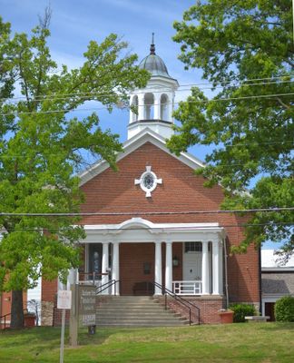
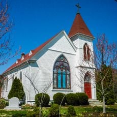
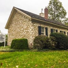
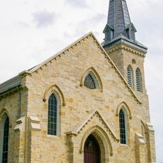
Manchester United Methodist Church, Protestant church in Manchester, Missouri, US.

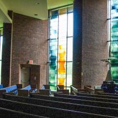
Manchester United Methodist Church is a Protestant church building with Greek Revival features located in Missouri, distinguished by its brick construction with prominent columns and limestone base. The interior was expanded in 1998 and includes a pipe organ with a distinctive moveable console system.

The congregation began meeting secretly in private homes in the late 1700s when the dominant religion in the region was Catholic. The construction of the building and its growth over generations shows how this place evolved from hidden gatherings to one of the largest churches in the region.

The congregation has become one of the largest United Methodist communities in the state, holding a significant place in the local religious landscape. Visitors can sense the strong communal bonds today through regular gatherings and the active role the place plays in members' spiritual lives.

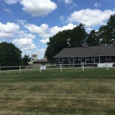
The location sits along Woods Mill Road and is easy to reach by car, with ample space for visitors on the grounds. The interior spaces are generously sized, making visits comfortable even when gatherings are large.

The church houses a pipe organ with a five-manual moveable console, the only one of its kind in Missouri. This technical feature makes the instrument particularly special for music lovers and organists.

Location: Missouri

Inception: 1859

Architectural style: Greek Revival architecture

Website: http://manchesterumc.org

GPS coordinates: 38.59472,-90.50944

Latest update: December 13, 2025 12:41

Photos
Around this place
Bellerive Country Club
United States of America

Bellerive Country Club

7.6 km
United States of America

Kirkwood City Council shooting

9.1 km
National Museum of Transportation
United States of America

National Museum of Transportation

4.8 km
The Magic House, St. Louis Children's Museum
United States of America

The Magic House, St. Louis Children's Museum

9.3 km
Castlewood State Park
United States of America

Castlewood State Park

5.6 km
Saint Louis Abbey
United States of America

Saint Louis Abbey

6.1 km
Lone Elk County Park
United States of America

Lone Elk County Park

7.5 km
Laumeier Sculpture Park
United States of America

Laumeier Sculpture Park

9.8 km
Kraus House
United States of America

Kraus House

6 km
St. Louis Missouri Temple
United States of America

St. Louis Missouri Temple

6.3 km
Hindu Temple of St. Louis
United States of America

Hindu Temple of St. Louis

2.4 km
Butterfly House, Missouri Botanical Garden
United States of America

Butterfly House, Missouri Botanical Garden

8.3 km
Theodore A. Pappas House
United States of America

Theodore A. Pappas House

5.2 km
Tyson Research Center
United States of America

Tyson Research Center

9.4 km
United States of America

Queeny Park

2.6 km
Cragwold
United States of America

Cragwold

7.6 km
Kirkwood Public Library
United States of America

Kirkwood Public Library

9.2 km
Congregation Shaare Emeth
United States of America

Congregation Shaare Emeth

9.1 km
Barretts Tunnels
United States of America

Barretts Tunnels

4.8 km
Emmenegger Nature Park
United States of America

Emmenegger Nature Park

8.1 km
Forest 44 Conservation Area
United States of America

Forest 44 Conservation Area

8.3 km
Temple Emanuel
United States of America

Temple Emanuel

7.5 km
Old Stone Church
United States of America

Old Stone Church

6.2 km
Olive Chapel African Methodist Episcopal Church
United States of America

Olive Chapel African Methodist Episcopal Church

8.8 km
Des Peres Presbyterian Church
United States of America

Des Peres Presbyterian Church

8.4 km
Eliot Unitarian Chapel
United States of America

Eliot Unitarian Chapel

9.4 km
Possum Woods Conservation Area
United States of America

Possum Woods Conservation Area

8.6 km
Burkhardt Historic District
United States of America

Burkhardt Historic District

9.8 km
Show the full map
Reviews

Visited this place? Tap the stars to rate it and share your experience / photos with the community! Try now! You can cancel it anytime.

« Manchester United Methodist Church - Protestant church in Manchester, Missouri, US » is provided by Around Us (aroundus.com). Images and texts are derived from Wikimedia project under a Creative Commons license. You are allowed to copy, distribute, and modify copies of this page, under the conditions set by the license, as long as this note is clearly visible.

Discover hidden gems everywhere you go!

From secret cafés to breathtaking viewpoints, skip the crowded tourist spots and find places that match your style. Our app makes it easy with voice search, smart filtering, route optimization, and insider tips from travelers worldwide. Download now for the complete mobile experience.

Around Us App Screenshot

A unique approach to discovering new places

Le Figaro

All the places worth exploring

France Info

A tailor-made excursion in just a few clicks

20 Minutes