Enable Location

We need your location to show you interesting places around you

Discover nearby places

Find interesting locations and hidden gems around you

Precise directions

Get accurate directions and distances to places

Your location is never shared with other users. It's only used when you tap the location button.

Log in to your account

Start exploring — it's free

Trusted by 61,673 travelers worldwide

Continue with Google
Continue with Apple
or

We will send you a code to connect

By continuing, you accept our Terms and Conditions and our Privacy Policy

Check your inbox

We've sent a pincode in your inbox. Please enter the code below.

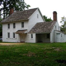
Walker-Combs-Hartshorne Farmstead, Historic farmstead in Freehold Township, United States

Description

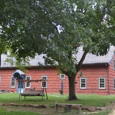
The Walker-Combs-Hartshorne Farmstead is a historic house built in 1686 with multiple additions constructed over time using fieldstone foundations and hand-hewn timber framing. The property today preserves roughly six acres of the original farmland and includes several outbuildings that once supported daily agricultural work.

History

The property started in 1686 as a small settler's cabin on a large plot of land and expanded gradually through the centuries as families added structures and cleared more fields. By the 1900s, it had grown into a substantial working farm that reflected the region's agricultural heritage.

Culture

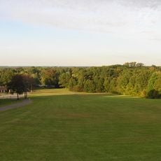
The farmstead shows how owners shifted from growing food just for themselves to producing crops for wider markets as the area developed. The remaining fields around the buildings reflect this move toward commercial farming.

Practical

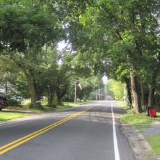
The property sits along Wemrock Road and can be viewed from the surrounding area, though it remains private and is not open for interior tours. The exterior structures and the way the land is organized give a good sense of how such farms were laid out and operated.

Did you know?

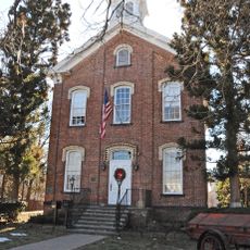
The property contains one of only two remaining toll houses left in New Jersey, built around 1850 along what was then the main Burlington Path trade route. This small structure offers a tangible connection to an era when travelers paid fees to use this important road.

GPS coordinates
40.24917,-74.30833
Latest update
December 14, 2025 16:45

AroundUs brings together thousands of curated places, local tips, and hidden gems, enriched daily by 60,000 contributors worldwide. Discover all places nearby (Freehold Township).

Around this place
Kingda Ka
United States of America

Kingda Ka

16.2 km
Zumanjaro: Drop of Doom
United States of America

Zumanjaro: Drop of Doom

16.1 km
El Toro
United States of America

El Toro

16.3 km
Green Lantern
United States of America

Green Lantern

16.6 km
Rolling Thunder
United States of America

Rolling Thunder

16.3 km
Viper
United States of America

Viper

16.3 km
Delicious Orchards
United States of America

Delicious Orchards

12.1 km
Ultra Twister
United States of America

Ultra Twister

16.4 km
Runaway Mine Train
United States of America

Runaway Mine Train

16.4 km
Medusa
United States of America

Medusa

16.2 km
United States of America

Old Tennent Church

5.6 km
Co-Cathedral of St. Robert Bellarmine
United States of America

Co-Cathedral of St. Robert Bellarmine

4 km
Hankinson-Moreau-Covenhoven House
United States of America

Hankinson-Moreau-Covenhoven House

1.9 km
Temple Shaari Emeth
United States of America

Temple Shaari Emeth

4 km
Buckelew Mansion
United States of America

Buckelew Mansion

15.3 km
George Taylor House
United States of America

George Taylor House

4 km
Old Scots Graveyard
United States of America

Old Scots Graveyard

10.9 km
Upper Meeting House of the Baptist Church of Middletown
United States of America

Upper Meeting House of the Baptist Church of Middletown

14.8 km
Monmouth County Jewish Heritage Museum
United States of America

Monmouth County Jewish Heritage Museum

741 m
Kovenhoven
United States of America

Kovenhoven

16.1 km
Thompson Park
United States of America

Thompson Park

14.1 km
Old Kentuck
United States of America

Old Kentuck

14.9 km
Church Street School
United States of America

Church Street School

2.8 km
Clarksburg Methodist Episcopal Church
United States of America

Clarksburg Methodist Episcopal Church

13.8 km
Probasco-Dittner Farmstead
United States of America

Probasco-Dittner Farmstead

9.8 km
Monmouth County Horse Show
United States of America

Monmouth County Horse Show

5.2 km
Manasquan Reservoir
United States of America

Manasquan Reservoir

11.6 km
Jersey Homesteads Historic District
United States of America

Jersey Homesteads Historic District

14.4 km
Show the full map
« Walker-Combs-Hartshorne Farmstead - Historic farmstead in Freehold Township, United States » is provided by Around Us (aroundus.com). Images and texts are derived from Wikimedia project under a Creative Commons license. You are allowed to copy, distribute, and modify copies of this page, under the conditions set by the license, as long as this note is clearly visible.

Discover hidden gems everywhere you go!

From secret cafés to breathtaking viewpoints, skip the crowded tourist spots and find places that match your style. Our app makes it easy with voice search, smart filtering, route optimization, and insider tips from travelers worldwide. Download now for the complete mobile experience.

Around Us App Screenshot

A unique approach to discovering new places

Le Figaro

All the places worth exploring

France Info

A tailor-made excursion in just a few clicks

20 Minutes

Around Us
Travel Guide & Maps
Download

Send to your phone

QR Code
1

Open the camera app on your mobile.

2

Point at the QR code with your camera. A notification will appear.

3

Tap the notification to open the link.