Enable Location

We need your location to show you interesting places around you

Discover nearby places

Find interesting locations and hidden gems around you

Precise directions

Get accurate directions and distances to places

Your location is never shared with other users. It's only used when you tap the location button.

Log in to your account

Start exploring — it's free

Trusted by 62,271 travelers worldwide

Continue with Google
Continue with Apple
or

We will send you a code to connect

By continuing, you accept our Terms and Conditions and our Privacy Policy

Check your inbox

We've sent a pincode in your inbox. Please enter the code below.

Kanawha Falls

Kanawha Falls, Waterfall in Glen Ferris, West Virginia, US.

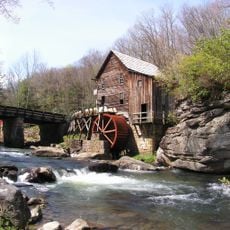
Kanawha Falls is a waterfall on the Kanawha River formed where a sandstone ledge creates roughly a 15-foot drop as water pours over natural rock formations. The river changes character at this point, showing visitors a clear dividing line in the landscape between two different sections of the waterway.

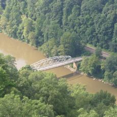
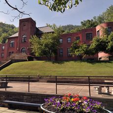
The waterfall formed through natural erosion and long served as a barrier that separated fish populations living above and below the drop. A hydroelectric plant built in 1899 began tapping the water's power, with a concrete overflow dam added in 1920 to manage water flow.

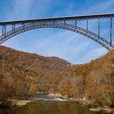
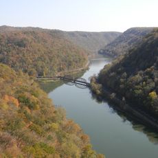
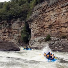
The location marks a transition point between industrial barge navigation downstream and recreational white-water rafting activities in the upper sections of the river.

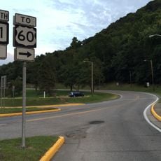
The falls can be reached easily from US Route 60, where there is parking and viewing areas set up for visitors. The setup makes it simple to stop and enjoy the waterfall without needing to undertake difficult hikes or extensive walking.

A hydroelectric plant constructed in 1899 continues to harness the water power from the falls, utilizing a concrete overflow dam built in 1920.

The community of curious travelers

AroundUs brings together thousands of curated places, local tips, and hidden gems, enriched daily by 60,000 contributors worldwide.

Start exploring
GPS coordinates
38.15278,-81.21222
Latest update
December 12, 2025 08:01
Around this place
New River Gorge Bridge
United States of America

New River Gorge Bridge

14.7 km
Summersville Lake
United States of America

Summersville Lake

29.2 km
Hawks Nest State Park
United States of America

Hawks Nest State Park

8.1 km
Babcock State Park
United States of America

Babcock State Park

27.5 km
Carnifex Ferry Battlefield State Park
United States of America

Carnifex Ferry Battlefield State Park

24.7 km
Ace Adventure Resort
United States of America

Ace Adventure Resort

22.4 km
Oak Hill High School
United States of America

Oak Hill High School

18.8 km
Tunney Hunsaker Bridge
United States of America

Tunney Hunsaker Bridge

15.4 km
Glen Ferris Inn
United States of America

Glen Ferris Inn

351 m
Bank of Glen Jean
United States of America

Bank of Glen Jean

25.5 km
Page-Vawter House
United States of America

Page-Vawter House

9.8 km
Camp Washington-Carver Complex
United States of America

Camp Washington-Carver Complex

26.5 km
Altamont Hotel
United States of America

Altamont Hotel

14.8 km
Cedar Grove
United States of America

Cedar Grove

20.4 km
Contentment
United States of America

Contentment

9.8 km
Booker T. Washington High School
United States of America

Booker T. Washington High School

14.9 km
E. B. Hawkins House
United States of America

E. B. Hawkins House

15 km
Fayetteville Historic District
United States of America

Fayetteville Historic District

14.6 km
Mount Hope Historic District
United States of America

Mount Hope Historic District

29.2 km
Fayette County Courthouse
United States of America

Fayette County Courthouse

14.6 km
New River Company General Office Building
United States of America

New River Company General Office Building

28.8 km
Pratt Historic District
United States of America

Pratt Historic District

16.3 km
Earl M. Vickers Bridge
United States of America

Earl M. Vickers Bridge

9.7 km
Glade Creek Grist Mill
United States of America

Glade Creek Grist Mill

30.2 km
Fayette Station Road
United States of America

Fayette Station Road

15 km
Kay Moor
United States of America

Kay Moor

17.4 km
Main Building
United States of America

Main Building

10.3 km
Nuttall Coal Mine Conveyor
United States of America

Nuttall Coal Mine Conveyor

18.7 km
Show the full map
« Kanawha Falls - Waterfall in Glen Ferris, West Virginia, US » is provided by Around Us (aroundus.com). Images and texts are derived from Wikimedia project under a Creative Commons license. You are allowed to copy, distribute, and modify copies of this page, under the conditions set by the license, as long as this note is clearly visible.

Discover hidden gems everywhere you go!

From secret cafés to breathtaking viewpoints, skip the crowded tourist spots and find places that match your style. Our app makes it easy with voice search, smart filtering, route optimization, and insider tips from travelers worldwide. Download now for the complete mobile experience.

Around Us App Screenshot

A unique approach to discovering new places

Le Figaro

All the places worth exploring

France Info

A tailor-made excursion in just a few clicks

20 Minutes

Around Us
Travel Guide & Maps
Download

Send to your phone

QR Code
1

Open the camera app on your mobile.

2

Point at the QR code with your camera. A notification will appear.

3

Tap the notification to open the link.