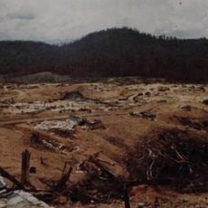
The Rockpile, Military observation point in Quảng Trị Province, Vietnam
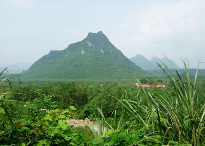
The Rockpile is a solitary karst formation rising 240 meters (787 feet) above the Cam Lo River in Quảng Trị Province, positioned at the junction of five valleys. The structure features steep limestone faces and a narrow summit, creating a dramatic silhouette visible from considerable distances across the surrounding landscape.
From 1966 to 1969, United States forces established a forward military outpost atop the formation to monitor troop movements and supply routes from North Vietnam and Laos. The position served as a critical intelligence-gathering point during the broader conflict, observing activities across an extensive area of central Vietnam.
The site embodies shared memories of conflict and serves as a meeting place where American veterans and Vietnamese visitors come together to reflect on wartime experiences. Today, people from both nations gather here to honor the past and acknowledge its continuing impact on their communities.
Reaching the summit requires helicopter access due to the steep terrain, making conventional hiking routes impossible. Visitors without helicopter arrangements can still observe and photograph the formation from ground-level viewing areas positioned at nearby locations.
The formation sits at the intersection of five river valleys, providing visibility and surveillance capabilities across approximately 16 kilometers of terrain during wartime. This geographic position made it one of the most strategically valuable locations in the entire region.
The community of curious travelers
AroundUs brings together thousands of curated places, local tips, and hidden gems, enriched daily by 60,000 contributors worldwide.