Enable Location

We need your location to show you interesting places around you

Discover nearby places

Find interesting locations and hidden gems around you

Precise directions

Get accurate directions and distances to places

Your location is never shared with other users. It's only used when you tap the location button.

West Fork Trailhead

Log in to your account

Start exploring — it's free

Trusted by 61,561 travelers worldwide

Continue with Google
Continue with Apple
or

We will send you a code to connect

By continuing, you accept our Terms and Conditions and our Privacy Policy

Check your inbox

We've sent a pincode in your inbox. Please enter the code below.

West Fork Trailhead

West Fork Trailhead, Trailhead at Coconino National Forest, United States.

Description

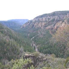
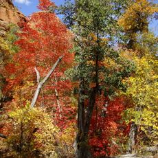
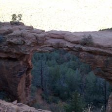
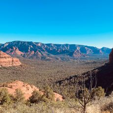
West Fork Trailhead is an access point to a hiking route in Coconino National Forest that runs for about 3 miles through a valley with red rock formations and dense forest. The path follows Oak Creek upstream and crosses the water multiple times between steep canyon walls.

History

Native American tribes used passages through this canyon region for trade and movement hundreds of years ago. These ancient routes later became the foundation for the modern hiking trail.

Culture

The trail demonstrates the preservation efforts of federal land management, connecting visitors with the natural heritage of northern Arizona's wilderness.

Practical

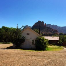
The parking area has basic facilities and signs to help hikers orient themselves. The route requires sturdy hiking shoes and clothing that can get wet from repeated water crossings.

Did you know?

The trail crosses Oak Creek dozens of times, forcing hikers to manage wet feet and gear repeatedly. This makes the experience distinct from typical flat, dry hiking routes.

Location
Fee
Yes
Address
W Fork Trail, Sedona, AZ 86336, USA
GPS coordinates
34.99064,-111.74247
Latest update
December 14, 2025 11:44

AroundUs brings together thousands of curated places, local tips, and hidden gems, enriched daily by 60,000 contributors worldwide. Discover all places nearby (Coconino County).

Around this place
Lowell Observatory
United States of America

Lowell Observatory

24.7 km
Oak Creek Canyon
United States of America

Oak Creek Canyon

8.8 km
Cathedral Rock
United States of America

Cathedral Rock

19.6 km
Slide Rock State Park
United States of America

Slide Rock State Park

8.5 km
Red Rock State Park
United States of America

Red Rock State Park

21.1 km
Bell Rock
United States of America

Bell Rock

21.3 km
Red Rock-Secret Mountain Wilderness
United States of America

Red Rock-Secret Mountain Wilderness

10.8 km
Riordan Mansion State Historic Park
United States of America

Riordan Mansion State Historic Park

23.4 km
Courthouse Butte
United States of America

Courthouse Butte

21.1 km
Weatherford Hotel
United States of America

Weatherford Hotel

24.7 km
Sycamore Canyon Wilderness
United States of America

Sycamore Canyon Wilderness

22.4 km
Cathedral Rock Trailhead
United States of America

Cathedral Rock Trailhead

18.9 km
The Arboretum at Flagstaff
United States of America

The Arboretum at Flagstaff

18.9 km
Railroad Addition Historic District
United States of America

Railroad Addition Historic District

24.6 km
Our Lady of Guadaloupe Church
United States of America

Our Lady of Guadaloupe Church

24.2 km
Soldier Pass Trailhead (Southernmost)
United States of America

Soldier Pass Trailhead (Southernmost)

12.4 km
Sedona Ranger Station
United States of America

Sedona Ranger Station

14.4 km
Brannen-Devine House
United States of America

Brannen-Devine House

24.3 km
Riordan Mansion
United States of America

Riordan Mansion

23.2 km
Sedona Heritage Museum
United States of America

Sedona Heritage Museum

12.6 km
Flagstaff Armory
United States of America

Flagstaff Armory

24.1 km
Flagstaff Southside Historic District
United States of America

Flagstaff Southside Historic District

24.2 km
Woody Mountain Lookout Tower
United States of America

Woody Mountain Lookout Tower

16.9 km
Devil's Bridge, Sedona
United States of America

Devil's Bridge, Sedona

12 km
Brins Mesa Trailhead
United States of America

Brins Mesa Trailhead

11.6 km
Wilson Mountain Trailhead
United States of America

Wilson Mountain Trailhead

11.6 km
Midgley Bridge
United States of America

Midgley Bridge

11.7 km
Northern Arizona Normal School Historic District
United States of America

Northern Arizona Normal School Historic District

23.9 km
Show the full map
« West Fork Trailhead - Trailhead at Coconino National Forest, United States » is provided by Around Us (aroundus.com). Images and texts are derived from Wikimedia project under a Creative Commons license. You are allowed to copy, distribute, and modify copies of this page, under the conditions set by the license, as long as this note is clearly visible.

Discover hidden gems everywhere you go!

From secret cafés to breathtaking viewpoints, skip the crowded tourist spots and find places that match your style. Our app makes it easy with voice search, smart filtering, route optimization, and insider tips from travelers worldwide. Download now for the complete mobile experience.

Around Us App Screenshot

A unique approach to discovering new places

Le Figaro

All the places worth exploring

France Info

A tailor-made excursion in just a few clicks

20 Minutes

Around Us
Travel Guide & Maps
Download

Send to your phone

QR Code
1

Open the camera app on your mobile.

2

Point at the QR code with your camera. A notification will appear.

3

Tap the notification to open the link.