Chest opened
+${chestReward.xp} XP
Explorer
NOUVEAU ×${chestReward.collectible.quantity}
tapez pour fermer
Chest locked

Open chests in the app

Around Us is built for your phone — chests unlock when you walk, explore and capture nearby places.

Enable Location

We need your location to show you interesting places around you

Discover nearby places

Find interesting locations and hidden gems around you

Precise directions

Get accurate directions and distances to places

Your location is never shared with other users. It's only used when you tap the location button.

Log in to your account

Start exploring — it's free

Trusted by 72,881 travelers worldwide

Continue with Google
Continue with Apple
or

We will send you a code to connect

By continuing, you accept our Terms and Conditions and our Privacy Policy

Check your inbox

We've sent a pincode in your inbox. Please enter the code below.

Lee Lake
Discussion Reviews Photo
1.2k Popularity

Lee Lake, body of water

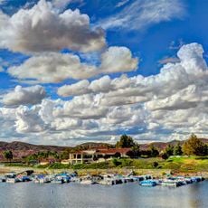
Lee Lake is a reservoir in Riverside County, California, created by a dam across Temescal Creek and situated at about 1,122 feet above sea level. The body of water is surrounded by green hills and trees that form a gentle shoreline easy to walk along, with a calm surface reflecting the sky and clouds.

The site was originally a natural lake called Lagunita that appeared on maps from 1860, showing its long presence in the region. In the late 1800s, the South Riverside Land and Water Company acquired land and water rights, constructing the dam to supply water to growing communities and expand the reservoir for long-term use.

The lake is known locally as Corona Lake among fishing enthusiasts, reflecting how the community has referred to this place over time. The shoreline serves as a gathering spot where visitors watch birds and experience the simple, quiet way of spending leisure time outdoors.

The lake can be easily explored on foot in a few hours, with gentle paths along the shoreline making it accessible for most visitors. Bring your own supplies as there are no shops nearby, and plan your visit during warmer months when families and fishermen are most active.

The site was once a natural lake basin called Lagunita before being transformed into a reservoir, a hidden history now built into the landscape. By 1900, the U.S. Geological Survey had already mapped the dam clearly, showing how long this water management system has shaped the region.

The community of curious travelers

AroundUs brings together thousands of curated places, local tips, and hidden gems, enriched daily by 60,000 contributors worldwide.

Start exploring
Location
GPS coordinates
33.74750,-117.44111
Latest update
February 9, 2026 07:46
Around this place
Saddleback Church
United States of America

Saddleback Church

21.2 km
Lake Mathews
United States of America

Lake Mathews

10.5 km
Santiago Peak
United States of America

Santiago Peak

9.6 km
Silverado Canyon
United States of America

Silverado Canyon

13.1 km
California Citrus State Historic Park
United States of America

California Citrus State Historic Park

16.7 km
Orange Empire Railway Museum
United States of America

Orange Empire Railway Museum

19.4 km
Cook's Corner
United States of America

Cook's Corner

18 km
St. Michael's Abbey
United States of America

St. Michael's Abbey

18.1 km
Modjeska House
United States of America

Modjeska House

17.6 km
California Theatre
United States of America

California Theatre

14.1 km
Atchison, Topeka and Santa Fe Railway 108
United States of America

Atchison, Topeka and Santa Fe Railway 108

19.3 km
Canyon Lake
United States of America

Canyon Lake

17.3 km
Vedanta Society Of Southern California, Ramakrishna Monastery
United States of America

Vedanta Society Of Southern California, Ramakrishna Monastery

17.7 km
Heritage House
United States of America

Heritage House

20.9 km
Modjeska Peak
United States of America

Modjeska Peak

10 km
Grand Boulevard
United States of America

Grand Boulevard

18.3 km
United States of America

Railroad Canyon

15.9 km
United States of America

Walker Canyon

4.7 km
YMCA Building
United States of America

YMCA Building

21.6 km
Los Pinos Peak
United States of America

Los Pinos Peak

9.6 km
San Mateo Peak
United States of America

San Mateo Peak

16 km
Trabuco Peak
United States of America

Trabuco Peak

5.9 km
United States of America

Estelle Mountain

2.9 km
Greystone Villa-Cabin 18
United States of America

Greystone Villa-Cabin 18

18.5 km
Woman's Improvement Club Clubhouse
United States of America

Woman's Improvement Club Clubhouse

17.9 km
Category:Fender Guitar Factory museum
United States of America

Category:Fender Guitar Factory museum

21.8 km
Rome Hill
United States of America

Rome Hill

17 km
Národní památník Prisoner of War/Missing in Action
United States of America

Národní památník Prisoner of War/Missing in Action

21.2 km
Show the full map
Reviews
Share your experience

No review yet

Discussions
Start a discussion...

No discussion yet

« Lee Lake - body of water » is provided by Around Us (aroundus.com). Images and texts are derived from Wikimedia project under a Creative Commons license. You are allowed to copy, distribute, and modify copies of this page, under the conditions set by the license, as long as this note is clearly visible.

Discover hidden gems everywhere you go!

From secret cafés to breathtaking viewpoints, skip the crowded tourist spots and find places that match your style. Our app makes it easy with voice search, smart filtering, route optimization, and insider tips from travelers worldwide. Download now for the complete mobile experience.

Around Us App Screenshot

A unique approach to discovering new places

Le Figaro

All the places worth exploring

France Info

A tailor-made excursion in just a few clicks

20 Minutes

Around Us
Travel Guide & Maps
Download

Send to your phone

QR Code
1

Open the camera app on your mobile.

2

Point at the QR code with your camera. A notification will appear.

3

Tap the notification to open the link.