Gulf of Mexico basin, Sedimentary basin in Gulf of Mexico, Mexico
The Gulf of Mexico basin is a sedimentary basin that sits beneath the Gulf of Mexico, stretching from the southeastern coast of the United States down to the Yucatan Block in Mexico. It consists of thick layers of rock built up over a very long period, sitting beneath both open water and coastal land.
The basin began to form around 160 million years ago in the early Jurassic period, when tectonic movements pulled apart landmasses and opened a new marine space. Over millions of years, sediments filled this space and slowly built up into the rock layers that exist today.
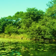
The fishing communities along the Gulf coast have built their daily routines around the waters above this basin for generations. In ports like Veracruz or Tampico, the connection to the sea is visible in the markets, the boats, and the food.
The basin lies beneath the seafloor and cannot be visited directly, but its presence is felt all along the Gulf coast through the ports, oil platforms visible from shore, and fishing activity. If you want to learn more about its geology, coastal cities like Tampico and Veracruz have museums and research centers with related exhibits.
Beneath the basin lies a thick layer of salt that formed over 150 million years ago and still acts as a natural seal trapping oil and gas reservoirs below. This salt shifts and deforms under pressure, creating dome-shaped structures that geologists call salt diapirs, which guided much of the offshore drilling activity in the region.
The community of curious travelers
AroundUs brings together thousands of curated places, local tips, and hidden gems, enriched daily by 60,000 contributors worldwide.