Rio Vista Bridge

Log in to your account

AroundUs is a community-driven map of interesting places, built by curious explorers like you. It grows with every review, story, and photo you share.
Connect to save your favorite spots, contribute locations, and create personalized routes.
Continue with Google
Continue with Apple
Continue with X
Continue with Facebook
Continue with email
By continuing, you accept our Terms and Conditions and our Privacy Policy
Create an account
Add to collection
Map
Suggest a change
Share

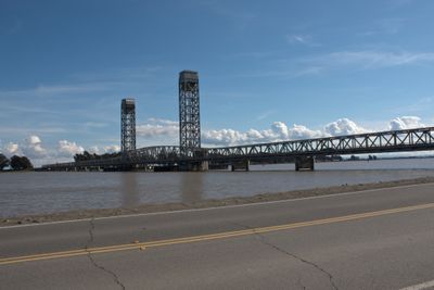
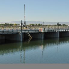
Rio Vista Bridge, Vertical-lift bridge in Rio Vista, California

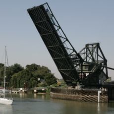
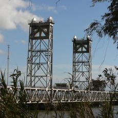
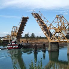
Rio Vista Bridge is a vertical-lift bridge carrying State Route 12 across the Sacramento River with substantial overall length. Its central span raises vertically to permit vessels to pass through with clearance reaching about 135 feet.

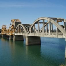
The current bridge was completed in 1960, replacing an earlier bascule bridge from 1919 that had served the river crossing. The new design earned recognition from the American Institute of Steel Construction for its engineering.

The bridge carries the name Helen Madere Memorial Bridge in honor of a former Rio Vista vice-mayor who championed traffic safety improvements on California State Route 12. Local residents often mention this connection when talking about community leaders who left their mark on the town.

The bridge operates daily for road traffic and raises as needed for large vessels, which means brief waiting periods are possible. Best to drive attentively during peak hours and note that pedestrians and cyclists have designated areas.

In 1967, the Italian freighter Ilice collided with the raised span, destroying an entire truss section. Emergency repairs were completed within three weeks, showing the structural resilience of the design.

Location: California

Official opening: April 1, 1960

GPS coordinates: 38.15871,-121.68382

Latest update: December 10, 2025 16:28

Photos
Around this place
Locke
United States of America

Locke

18.4 km
Black Diamond Mines Regional Preserve
United States of America

Black Diamond Mines Regional Preserve

27.7 km
Antioch Bridge
United States of America

Antioch Bridge

16.1 km
Western Railway Museum
United States of America

Western Railway Museum

17.4 km
Cosumnes River Preserve
United States of America

Cosumnes River Preserve

24.5 km
Franks Tract State Recreation Area
United States of America

Franks Tract State Recreation Area

12.9 km
Antioch Dunes National Wildlife Refuge
United States of America

Antioch Dunes National Wildlife Refuge

18.6 km
Stone Lakes National Wildlife Refuge
United States of America

Stone Lakes National Wildlife Refuge

28.4 km
Stone House of John Marsh
United States of America

Stone House of John Marsh

29.9 km
Delta Meadows Park Property
United States of America

Delta Meadows Park Property

19.4 km
Contra Costa Canal
United States of America

Contra Costa Canal

19.4 km
Isleton Bridge
United States of America

Isleton Bridge

8 km
Travis Air Force Base Aviation Museum
United States of America

Travis Air Force Base Aviation Museum

25 km
Contra Loma Regional Park
United States of America

Contra Loma Regional Park

21.5 km
Jones Tract
United States of America

Jones Tract

30.1 km
Walnut Grove Japanese-American Historic District
United States of America

Walnut Grove Japanese-American Historic District

17.7 km
Hastings Adobe
United States of America

Hastings Adobe

15.8 km
Isleton Chinese and Japanese Commercial Districts
United States of America

Isleton Chinese and Japanese Commercial Districts

6.9 km
Twitchell Island
United States of America

Twitchell Island

6.3 km
Bouldin Island
United States of America

Bouldin Island

14.4 km
King Island
United States of America

King Island

24 km
Rosebud Ranch
United States of America

Rosebud Ranch

29.3 km
Shannon-Williamson Ranch
United States of America

Shannon-Williamson Ranch

23 km
Roswell Butler Hard House
United States of America

Roswell Butler Hard House

19.5 km
Riverview Union High School Building
United States of America

Riverview Union High School Building

20.2 km
Walnut Grove Bridge
United States of America

Walnut Grove Bridge

17.4 km
Three Mile Slough Bridge
United States of America

Three Mile Slough Bridge

6 km
Paintersville Bridge
United States of America

Paintersville Bridge

20.1 km
Show the full map
Reviews

Visited this place? Tap the stars to rate it and share your experience / photos with the community! Try now! You can cancel it anytime.

« Rio Vista Bridge - Vertical-lift bridge in Rio Vista, California » is provided by Around Us (aroundus.com). Images and texts are derived from Wikimedia project under a Creative Commons license. You are allowed to copy, distribute, and modify copies of this page, under the conditions set by the license, as long as this note is clearly visible.

Discover hidden gems everywhere you go!

From secret cafés to breathtaking viewpoints, skip the crowded tourist spots and find places that match your style. Our app makes it easy with voice search, smart filtering, route optimization, and insider tips from travelers worldwide. Download now for the complete mobile experience.

Around Us App Screenshot

A unique approach to discovering new places

Le Figaro

All the places worth exploring

France Info

A tailor-made excursion in just a few clicks

20 Minutes