Enable Location

We need your location to show you interesting places around you

Discover nearby places

Find interesting locations and hidden gems around you

Precise directions

Get accurate directions and distances to places

Your location is never shared with other users. It's only used when you tap the location button.

Antioch Dunes National Wildlife Refuge

Log in to your account

Start exploring — it's free

Trusted by 61,993 travelers worldwide

Continue with Google
Continue with Apple
or

We will send you a code to connect

By continuing, you accept our Terms and Conditions and our Privacy Policy

Check your inbox

We've sent a pincode in your inbox. Please enter the code below.

Antioch Dunes National Wildlife Refuge

Antioch Dunes National Wildlife Refuge, Nature reserve along San Joaquin River in Antioch, United States.

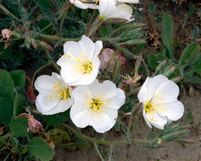
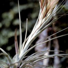
Antioch Dunes National Wildlife Refuge is a nature reserve featuring sand dunes along the San Joaquin River that span about 27 hectares (67 acres). The dunes were shaped by ancient deposits from the Sierra Nevada mountains and now support rare plants and insects found nowhere else.

The refuge was created in the 1980s following extensive sand mining in the early 1900s that had drastically reduced the original dunes. It was established to prevent further loss of the habitat and protect the rare species that remained.

The name reflects the area's historical connection to ancient Antioch, and today it serves as a symbol of habitat restoration efforts in the region. Visitors on guided tours witness firsthand how dedicated conservation work protects vulnerable species from extinction.

Visitors must register in advance and join supervised tours to access the refuge and protect the delicate habitats inside. Monthly guided tours offer the best way to explore the area while learning about conservation efforts.

Three species of plants and insects live only in this location: the Lange's metalmark butterfly, the Antioch evening primrose, and the Contra Costa wallflower. These organisms have adapted specifically to the sand dunes and conditions found here.

The community of curious travelers

AroundUs brings together thousands of curated places, local tips, and hidden gems, enriched daily by 60,000 contributors worldwide.

Start exploring
Location
Operator
United States Fish and Wildlife Service
GPS coordinates
38.01530,-121.79328
Latest update
December 10, 2025 20:03
Around this place
Mount Diablo
United States of America

Mount Diablo

18.3 km
Sleep Train Pavilion
United States of America

Sleep Train Pavilion

14.8 km
Black Diamond Mines Regional Preserve
United States of America

Black Diamond Mines Regional Preserve

9.1 km
Antioch Bridge
United States of America

Antioch Bridge

3.9 km
Port Chicago Naval Magazine National Memorial
United States of America

Port Chicago Naval Magazine National Memorial

21.3 km
Western Railway Museum
United States of America

Western Railway Museum

22.1 km
Rio Vista Bridge
United States of America

Rio Vista Bridge

18.6 km
Franks Tract State Recreation Area
United States of America

Franks Tract State Recreation Area

14.1 km
Mount Diablo meridian
United States of America

Mount Diablo meridian

18.3 km
Stone House of John Marsh
United States of America

Stone House of John Marsh

15.1 km
Contra Costa Canal
United States of America

Contra Costa Canal

6.9 km
Marsh Creek State Park
United States of America

Marsh Creek State Park

14.7 km
Contra Loma Regional Park
United States of America

Contra Loma Regional Park

3.3 km
Don Francisco Galindo House
United States of America

Don Francisco Galindo House

21.7 km
Shadelands Ranch
United States of America

Shadelands Ranch

22.2 km
Hastings Adobe
United States of America

Hastings Adobe

7.6 km
Isleton Chinese and Japanese Commercial Districts
United States of America

Isleton Chinese and Japanese Commercial Districts

23.3 km
Don Salvio Pacheco Adobe
United States of America

Don Salvio Pacheco Adobe

21.9 km
Roe Island Light
United States of America

Roe Island Light

21.4 km
Twitchell Island
United States of America

Twitchell Island

16.5 km
Ryer Island
United States of America

Ryer Island

20.8 km
Shannon-Williamson Ranch
United States of America

Shannon-Williamson Ranch

6.6 km
Roswell Butler Hard House
United States of America

Roswell Butler Hard House

2 km
Markham Regional Arboretum
United States of America

Markham Regional Arboretum

19.2 km
Don Fernando Pacheco Adobe
United States of America

Don Fernando Pacheco Adobe

22 km
Riverview Union High School Building
United States of America

Riverview Union High School Building

2.9 km
Rainforest Flora
United States of America

Rainforest Flora

19.2 km
Three Mile Slough Bridge
United States of America

Three Mile Slough Bridge

12.9 km
Show the full map
« Antioch Dunes National Wildlife Refuge - Nature reserve along San Joaquin River in Antioch, United States » is provided by Around Us (aroundus.com). Images and texts are derived from Wikimedia project under a Creative Commons license. You are allowed to copy, distribute, and modify copies of this page, under the conditions set by the license, as long as this note is clearly visible.

Discover hidden gems everywhere you go!

From secret cafés to breathtaking viewpoints, skip the crowded tourist spots and find places that match your style. Our app makes it easy with voice search, smart filtering, route optimization, and insider tips from travelers worldwide. Download now for the complete mobile experience.

Around Us App Screenshot

A unique approach to discovering new places

Le Figaro

All the places worth exploring

France Info

A tailor-made excursion in just a few clicks

20 Minutes

Around Us
Travel Guide & Maps
Download

Send to your phone

QR Code
1

Open the camera app on your mobile.

2

Point at the QR code with your camera. A notification will appear.

3

Tap the notification to open the link.