Enable Location

We need your location to show you interesting places around you

Discover nearby places

Find interesting locations and hidden gems around you

Precise directions

Get accurate directions and distances to places

Your location is never shared with other users. It's only used when you tap the location button.

H.D. Woodson High School

Log in to your account

Start exploring — it's free

Trusted by 65,918 travelers worldwide

Continue with Google
Continue with Apple
or

We will send you a code to connect

By continuing, you accept our Terms and Conditions and our Privacy Policy

Check your inbox

We've sent a pincode in your inbox. Please enter the code below.

H.D. Woodson High School
Discussion Reviews 1 Photos
5.9k Popularity

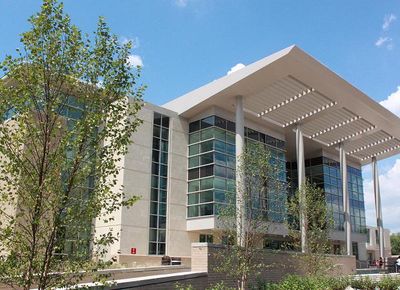
H.D. Woodson High School, Public high school in Northeast Boundary, United States

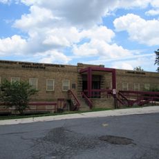
H.D. Woodson High School is a public secondary school in Northeast Washington, housed in a multi-story building that serves students in grades 9 through 12. The building contains classrooms, a swimming pool, and areas set aside for vocational training.

The school opened in 1972 as the first high-rise school building of its kind in the United States. Its construction marked a turning point in how urban school buildings were designed in the following decades.

The school is named after Howard Dilworth Woodson, a civil engineer who pushed for better schools in the Deanwood neighborhood. His name on the building serves as a daily reminder of local advocacy for education in this part of Washington.

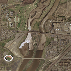
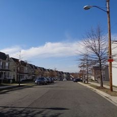
The school sits in a residential area of Northeast Washington and can be reached by public transit. Since it is an active school, any visit should be arranged in advance, and arriving outside school hours makes access easier.

The school has its own swimming pool, which is rare for a public school in Washington, and the swim team known as the Warrior Sharks trains there regularly. Despite limited resources, the team has built a reputation for holding its own in competition.

The community of curious travelers

AroundUs brings together thousands of curated places, local tips, and hidden gems, enriched daily by 60,000 contributors worldwide.

Start exploring
Location
GPS coordinates
38.89647,-76.92275
Latest update
March 3, 2026 22:41
Around this place
United States National Arboretum
United States of America

United States National Arboretum

4.1 km
National Capitol Columns
United States of America

National Capitol Columns

4.2 km
Deanwood
United States of America

Deanwood

1.3 km
Goshin
United States of America

Goshin

4 km
Kingman Island
United States of America

Kingman Island

3.6 km
Langston Golf Course
United States of America

Langston Golf Course

4 km
Capitol View
United States of America

Capitol View

765 m
Fort Dupont Park
United States of America

Fort Dupont Park

3.2 km
Bladensburg Dueling Grounds
United States of America

Bladensburg Dueling Grounds

3.5 km
Dupont Park
United States of America

Dupont Park

4.4 km
Benning
United States of America

Benning

2.3 km
Benning Ridge
United States of America

Benning Ridge

2.2 km
Whitney Young Memorial Bridge
United States of America

Whitney Young Memorial Bridge

3.7 km
Kenilworth Park and Aquatic Gardens
United States of America

Kenilworth Park and Aquatic Gardens

2.4 km
Ethel Kennedy Bridge
United States of America

Ethel Kennedy Bridge

3.5 km
Amtrak Railroad Anacostia Bridge
United States of America

Amtrak Railroad Anacostia Bridge

2.9 km
Mayfair Mansions Apartments
United States of America

Mayfair Mansions Apartments

2.4 km
Strand Theater
United States of America

Strand Theater

357 m
St. Matthew's Church
United States of America

St. Matthew's Church

1.3 km
New York Avenue Bridge
United States of America

New York Avenue Bridge

2.9 km
Benning / Dorothy I. Height Neighborhood Library
United States of America

Benning / Dorothy I. Height Neighborhood Library

2.2 km
Deanwood Neighborhood Library
United States of America

Deanwood Neighborhood Library

1.6 km
Fairmount Heights Historic District
United States of America

Fairmount Heights Historic District

784 m
National Bonsai and Penjing Museum
United States of America

National Bonsai and Penjing Museum

4.4 km
Nannie Helen Burroughs School
United States of America

Nannie Helen Burroughs School

633 m
Fort Dupont
United States of America

Fort Dupont

3.1 km
Fort Mahan
United States of America

Fort Mahan

1.9 km
Kingman Lake
United States of America

Kingman Lake

3.7 km
Show the full map
Reviews
Share your experience

No review yet

Discussions
Start a discussion...

No discussion yet

« H.D. Woodson High School - Public high school in Northeast Boundary, United States » is provided by Around Us (aroundus.com). Images and texts are derived from Wikimedia project under a Creative Commons license. You are allowed to copy, distribute, and modify copies of this page, under the conditions set by the license, as long as this note is clearly visible.

Discover hidden gems everywhere you go!

From secret cafés to breathtaking viewpoints, skip the crowded tourist spots and find places that match your style. Our app makes it easy with voice search, smart filtering, route optimization, and insider tips from travelers worldwide. Download now for the complete mobile experience.

Around Us App Screenshot

A unique approach to discovering new places

Le Figaro

All the places worth exploring

France Info

A tailor-made excursion in just a few clicks

20 Minutes

Around Us
Travel Guide & Maps
Download

Send to your phone

QR Code
1

Open the camera app on your mobile.

2

Point at the QR code with your camera. A notification will appear.

3

Tap the notification to open the link.