Enable Location

We need your location to show you interesting places around you

Discover nearby places

Find interesting locations and hidden gems around you

Precise directions

Get accurate directions and distances to places

Your location is never shared with other users. It's only used when you tap the location button.

Alpine Elementary School

Log in to your account

Start exploring — it's free

Trusted by 62,415 travelers worldwide

Continue with Google
Continue with Apple
or

We will send you a code to connect

By continuing, you accept our Terms and Conditions and our Privacy Policy

Check your inbox

We've sent a pincode in your inbox. Please enter the code below.

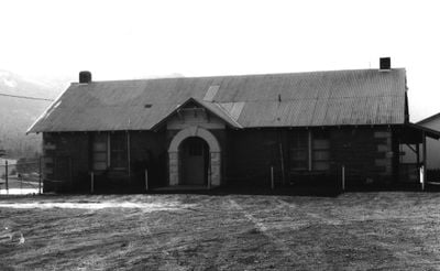
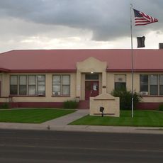
Alpine Elementary School, United States historic place

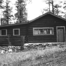
Alpine Elementary School is a primary school building in Apache County that has been recognized for its historic importance and early educational role in the community. The structure has a simple, sturdy design with traditional windows and straightforward construction that reflects practical building methods of its era.

The building was constructed in the early 1930s, making it nearly a century old and demonstrating its long-standing importance to education in the region. This extended history shows the school has been a symbol of educational commitment and community continuity throughout many generations.

The school served as a gathering place where the community came together for events and celebrations, strengthening bonds among families and neighbors. This role as a social hub reflects how people in this area have long valued education and local connection as central to their way of life.

The building has been carefully maintained to reveal the materials and construction techniques of its era, allowing visitors to appreciate how schools were built in earlier times. The quiet rural setting makes it an accessible place to visit and explore the story of education in this small community.

The school was built during an era when communities prioritized providing access to education for all children, and this structure stands today as a testament to that early commitment. Its preservation on the National Register helps protect the building and encourages people to learn about this important chapter in local educational history.

The community of curious travelers

AroundUs brings together thousands of curated places, local tips, and hidden gems, enriched daily by 60,000 contributors worldwide.

Start exploring
Location
Inception
1930
GPS coordinates
33.82722,-109.14361
Latest update
February 9, 2026 07:45
Around this place
Gila Wilderness
United States of America

Gila Wilderness

104.8 km
Morenci Mine
United States of America

Morenci Mine

84.6 km
Mount Baldy
United States of America

Mount Baldy

39.7 km
Round Valley Ensphere
United States of America

Round Valley Ensphere

35.2 km
Kinishba Ruins
United States of America

Kinishba Ruins

84.2 km
Escudilla Mountain
United States of America

Escudilla Mountain

14.5 km
Lyman Reservoir
United States of America

Lyman Reservoir

62.6 km
Apache National Forest
United States of America

Apache National Forest

27.7 km
Casa Malpaís
United States of America

Casa Malpaís

38.7 km
Cedar Canyon Bridge
United States of America

Cedar Canyon Bridge

101.7 km
Park Avenue Bridge
United States of America

Park Avenue Bridge

87 km
Lake Mountain Lookout Complex
United States of America

Lake Mountain Lookout Complex

68.5 km
Butterfly Lodge
United States of America

Butterfly Lodge

35.4 km
Whitewater Creek
United States of America

Whitewater Creek

61.8 km
Eagar Townsite Historic District
United States of America

Eagar Townsite Historic District

34.1 km
Corduroy Creek Bridge
United States of America

Corduroy Creek Bridge

98.2 km
Clifton Townsite Historic District
United States of America

Clifton Townsite Historic District

87.1 km
Eagar School
United States of America

Eagar School

34.1 km
Los Burros Ranger Station
United States of America

Los Burros Ranger Station

67.2 km
PS Knoll Lookout Complex
United States of America

PS Knoll Lookout Complex

24.9 km
Gila River Bridge
United States of America

Gila River Bridge

97.2 km
Mogollon Baldy Lookout Cabin
United States of America

Mogollon Baldy Lookout Cabin

80.1 km
Black Gap Bridge
United States of America

Black Gap Bridge

99.4 km
Gallo Mountains
United States of America

Gallo Mountains

56.8 km
Cosmic Campground
United States of America

Cosmic Campground

43.7 km
Show Low Historical Society
United States of America

Show Low Historical Society

95 km
Chase Creek Railroad Bridge
United States of America

Chase Creek Railroad Bridge

86.9 km
Mogollon Baldy Lookout
United States of America

Mogollon Baldy Lookout

80.1 km
Show the full map
« Alpine Elementary School - United States historic place » is provided by Around Us (aroundus.com). Images and texts are derived from Wikimedia project under a Creative Commons license. You are allowed to copy, distribute, and modify copies of this page, under the conditions set by the license, as long as this note is clearly visible.

Discover hidden gems everywhere you go!

From secret cafés to breathtaking viewpoints, skip the crowded tourist spots and find places that match your style. Our app makes it easy with voice search, smart filtering, route optimization, and insider tips from travelers worldwide. Download now for the complete mobile experience.

Around Us App Screenshot

A unique approach to discovering new places

Le Figaro

All the places worth exploring

France Info

A tailor-made excursion in just a few clicks

20 Minutes

Around Us
Travel Guide & Maps
Download

Send to your phone

QR Code
1

Open the camera app on your mobile.

2

Point at the QR code with your camera. A notification will appear.

3

Tap the notification to open the link.