Chest opened
+${chestReward.xp} XP
Explorer
NOUVEAU ×${chestReward.collectible.quantity}
tapez pour fermer
Chest locked

Open chests in the app

Around Us is built for your phone — chests unlock when you walk, explore and capture nearby places.

Enable Location

We need your location to show you interesting places around you

Discover nearby places

Find interesting locations and hidden gems around you

Precise directions

Get accurate directions and distances to places

Your location is never shared with other users. It's only used when you tap the location button.

Log in to your account

Start exploring — it's free

Trusted by 72,880 travelers worldwide

Continue with Google
Continue with Apple
or

We will send you a code to connect

By continuing, you accept our Terms and Conditions and our Privacy Policy

Check your inbox

We've sent a pincode in your inbox. Please enter the code below.

Cypress Pond
Discussion Reviews Photo
30+ Popularity

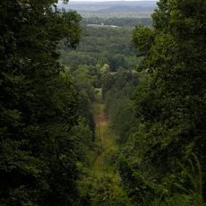
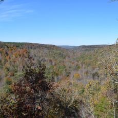
Cypress Pond, Natural swamp in Franklin County, US

Cypress Pond is a swamp in Franklin County shaped by blackwater and pond cypress trees that reach 15 to 18 meters in height. The trees grow in standing water and create a wooded wetland landscape typical of the region.

Botanist Adolphe-Théodore Brongniart first documented the pond cypress trees at this location during his research expeditions in 1833. This early scientific attention established the site as a recognized botanical location.

The pond cypress environment serves as a vital nesting ground for the flatwoods salamander, which exclusively lays eggs in these specific conditions.

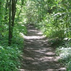
The site can be explored along marked paths that are most accessible in spring and fall when conditions are comfortable for visitors. During these seasons you can also observe wildlife more easily as animals are active in the area.

The thick bark of pond cypress trees here allows them to survive both extended flooding and severe drought periods. This adaptation enables the trees to thrive despite harsh and unpredictable water conditions.

The community of curious travelers

AroundUs brings together thousands of curated places, local tips, and hidden gems, enriched daily by 60,000 contributors worldwide.

Start exploring
Location
Elevation above the sea
158 m
GPS coordinates
34.45083,-88.09000
Latest update
December 15, 2025 13:24
Around this place
Woodall Mountain
United States of America

Woodall Mountain

40 km
Ivy Green
United States of America

Ivy Green

47.6 km
Natchez Trace Trail
United States of America

Natchez Trace Trail

24.1 km
Dismals Canyon
United States of America

Dismals Canyon

31.6 km
Tishomingo State Park
United States of America

Tishomingo State Park

19.5 km
Pharr Mounds
United States of America

Pharr Mounds

30 km
Barton Hall
United States of America

Barton Hall

34.5 km
Bay Springs Lake
United States of America

Bay Springs Lake

24.7 km
Jamie Whitten Lock and Dam
United States of America

Jamie Whitten Lock and Dam

22.9 km
Belle Mont
United States of America

Belle Mont

45.3 km
Cane Creek Canyon Nature Preserve
United States of America

Cane Creek Canyon Nature Preserve

33.1 km
Overton Farm
United States of America

Overton Farm

14.2 km
Fulton Lock
United States of America

Fulton Lock

37.5 km
G. V. Montgomery Lock
United States of America

G. V. Montgomery Lock

25.3 km
John Daniel Rather House
United States of America

John Daniel Rather House

47.5 km
Church of Our Saviour
United States of America

Church of Our Saviour

41.2 km
Colbert County Courthouse Square Historic District
United States of America

Colbert County Courthouse Square Historic District

47.4 km
Felix Grundy Norman House
United States of America

Felix Grundy Norman House

47.5 km
John and Archibald Christian House
United States of America

John and Archibald Christian House

46.2 km
Mulberry Creek
United States of America

Mulberry Creek

40.3 km
Alabama Music Hall of Fame
United States of America

Alabama Music Hall of Fame

45.8 km
Red Bay Water Park
United States of America

Red Bay Water Park

4.8 km
Belle Mont Mansion
United States of America

Belle Mont Mansion

45.3 km
Tammy Wynette Legacy Center
United States of America

Tammy Wynette Legacy Center

28.8 km
Colbert County Courthouse
United States of America

Colbert County Courthouse

47.4 km
Tishomingo State Park Historic District
United States of America

Tishomingo State Park Historic District

18.9 km
United States of America

Waterfall

19.2 km
United States of America

Colbert Ferry

45.2 km
Show the full map
Reviews
Share your experience

No review yet

Discussions
Start a discussion...

No discussion yet

« Cypress Pond - Natural swamp in Franklin County, US » is provided by Around Us (aroundus.com). Images and texts are derived from Wikimedia project under a Creative Commons license. You are allowed to copy, distribute, and modify copies of this page, under the conditions set by the license, as long as this note is clearly visible.

Discover hidden gems everywhere you go!

From secret cafés to breathtaking viewpoints, skip the crowded tourist spots and find places that match your style. Our app makes it easy with voice search, smart filtering, route optimization, and insider tips from travelers worldwide. Download now for the complete mobile experience.

Around Us App Screenshot

A unique approach to discovering new places

Le Figaro

All the places worth exploring

France Info

A tailor-made excursion in just a few clicks

20 Minutes

Around Us
Travel Guide & Maps
Download

Send to your phone

QR Code
1

Open the camera app on your mobile.

2

Point at the QR code with your camera. A notification will appear.

3

Tap the notification to open the link.