Enable Location

We need your location to show you interesting places around you

Discover nearby places

Find interesting locations and hidden gems around you

Precise directions

Get accurate directions and distances to places

Your location is never shared with other users. It's only used when you tap the location button.

Tanjung Rhu

Log in to your account

Start exploring — it's free

Trusted by 62,932 travelers worldwide

Continue with Google
Continue with Apple
or

We will send you a code to connect

By continuing, you accept our Terms and Conditions and our Privacy Policy

Check your inbox

We've sent a pincode in your inbox. Please enter the code below.

Tanjung Rhu
Discussion Reviews 1 Photos
900+ Popularity

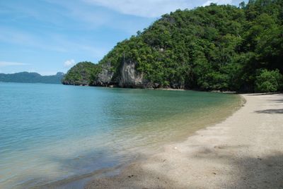
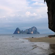
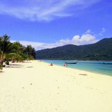
Tanjung Rhu, Cape and beach at the northeastern tip of Langkawi, Malaysia

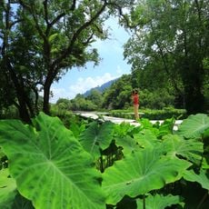
Tanjung Rhu is a cape and beach at the northeastern tip of Langkawi with white sand and tall casuarina trees lining the shore. Limestone cliffs and rock formations reach into the Andaman Sea, creating a dramatic curved coastline.

The location served as a major navigation landmark since the 15th century for ships passing through the Malacca Strait. This strategic position made it an important reference point for maritime traffic in the region.

The name comes from Malay words meaning 'cape' and 'casuarina trees,' which still line the shore today. These tall trees remain a defining feature of the landscape and shape what visitors see when they arrive.

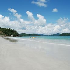
The beach is accessible through a small jetty with boat services for tours to nearby Kilim Geopark. Water and tide conditions change noticeably throughout the day, so timing matters for your visit.

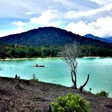
During low tide, shallow waters allow visitors to walk to nearby Pulau Chabang island and explore its own limestone rock formations. This temporary route offers an unexpected way to discover hidden island features that most visitors miss.

The community of curious travelers

AroundUs brings together thousands of curated places, local tips, and hidden gems, enriched daily by 60,000 contributors worldwide.

Start exploring
Location
GPS coordinates
6.45747,99.82444
Latest update
December 14, 2025 20:04
Reviews
Share your experience

No review yet

Discussions
Start a discussion...

No discussion yet

« Tanjung Rhu - Cape and beach at the northeastern tip of Langkawi, Malaysia » is provided by Around Us (aroundus.com). Images and texts are derived from Wikimedia project under a Creative Commons license. You are allowed to copy, distribute, and modify copies of this page, under the conditions set by the license, as long as this note is clearly visible.

Discover hidden gems everywhere you go!

From secret cafés to breathtaking viewpoints, skip the crowded tourist spots and find places that match your style. Our app makes it easy with voice search, smart filtering, route optimization, and insider tips from travelers worldwide. Download now for the complete mobile experience.

Around Us App Screenshot

A unique approach to discovering new places

Le Figaro

All the places worth exploring

France Info

A tailor-made excursion in just a few clicks

20 Minutes

Around Us
Travel Guide & Maps
Download

Send to your phone

QR Code
1

Open the camera app on your mobile.

2

Point at the QR code with your camera. A notification will appear.

3

Tap the notification to open the link.