Fandango Bridge, Road bridge in Cachoeira do Sul, Brazil
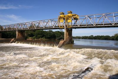
The Fandango Bridge is a road structure that spans 550 meters across the Jacui River and connects Cachoeira do Sul with major highways throughout Rio Grande do Sul state. The structure includes a lock system that allows river navigation along the northern section of the waterway.
The structure was built in 1961 using French engineering standards and was the second longest bridge of its kind worldwide at the time of completion. This construction shaped regional economic development and created new transportation links between different parts of the state.
The bridge takes its name from a traditional southern Brazilian dance form that defines the region's musical identity. This naming choice connects the structure to the local folklore and the dance traditions that remain central to life here.
Only cars and motorcycles can cross the bridge at present due to structural limitations, while trucks and buses must use alternative routes. Pedestrians should be aware that the bridge is primarily designed for motor vehicles.
When completed, this was one of the longest bridge structures of its kind in the world and attracted international attention at the time. This engineering achievement made it a landmark of 1960s Brazilian engineering expertise.
Location: Rio Grande do Sul
GPS coordinates: -30.06318,-52.89674
Latest update: December 13, 2025 12:42
St. John the Baptist Cathedral
59.3 km
Sanga da Alemoa
93.5 km
Forte de D. Pedro II de Caçapava
75.7 km
Château D'Eau
1.8 km
Ponte do Império
58.4 km
Paleontological Sites of Santa Maria
95.9 km
Estação Rodoviária de Santa Maria
95.7 km
Paleorrota
93.5 km
Paleontological Site Arroio Cancela
95.9 km
Igreja Matriz Nossa Senhora do Rosário
50.6 km
Basilica Shrine of Our Lady Mediatrix of All Graces
97.1 km
Private Reserve of Natural Heritage of University of Santa Cruz do Sul
83.4 km
Planetário da UFSM
87.9 km
Paleontological Site Jazigo Cinco
93.5 km
Museu de Arte Sacra de Rio Pardo
50.8 km
Comunidade Arnesto Penna Carneiro
71.1 km
Quarta Colônia State Park
78.1 km
Museum Aristides Carlos Rodrigues
45.5 km
Stones of Segredo Park
82.2 km
Casa de Ulhôa Cintra
75.9 km
Casa de Antônio Augusto Borges de Medeiros
76 km
Igreja Matriz Nossa Senhora da Assunção
75.9 km
Casa de Artes Regina Simonis
59.4 km
Forum
75.9 km
Banco Pelotense
2.4 km
Antiga Escola Militar
51 km
Prefeitura Municipal
59.6 km
Calçamento de Pedra, antigo, da rua da Ladeira, abrangendo o trecho situado entre a esquina da rua Andrade Neves e a praça da Matriz
50.5 kmVisited this place? Tap the stars to rate it and share your experience / photos with the community! Try now! You can cancel it anytime.
Discover hidden gems everywhere you go!
From secret cafés to breathtaking viewpoints, skip the crowded tourist spots and find places that match your style. Our app makes it easy with voice search, smart filtering, route optimization, and insider tips from travelers worldwide. Download now for the complete mobile experience.
A unique approach to discovering new places❞
— Le Figaro
All the places worth exploring❞
— France Info
A tailor-made excursion in just a few clicks❞
— 20 Minutes