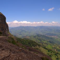
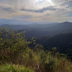
Pico do Itapeva, Mountain summit in Pindamonhangaba, Brazil.
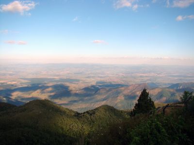
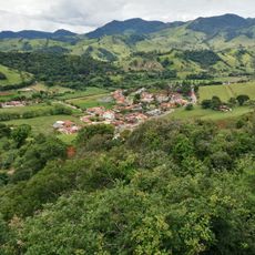
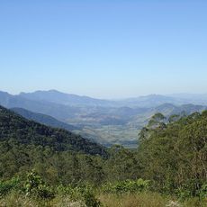
Pico do Itapeva is a mountain summit in Pindamonhangaba reaching 2,025 meters in elevation, positioned in the Vale do Paraíba region of São Paulo state. The peak sits high enough that you can see across much of the surrounding landscape and multiple municipalities from its top.
The peak's name comes from the Tupi language, combining 'ita' meaning stone and 'pec' meaning flat, referring to its distinctive summit shape. This indigenous term reflects how the land's geological features were understood by the people who first inhabited the region.
For many years, the summit hosted a traditional market for clothing and handicrafts until environmental preservation laws required its removal in 2014.
You can reach the summit by vehicle via a paved road from Campos do Jordão, making it accessible without hiking. Weather conditions in the mountains change quickly, so visitors should be prepared for clouds or wind even on days that start clear.
The peak sits just 35 meters from the boundary between Pindamonhangaba and Campos do Jordão at its summit. This geographical quirk means the top sits almost exactly on the line between two municipalities.
GPS coordinates: -22.76472,-45.52944
Latest update: December 6, 2025 16:04
Southeast Brazil spans the states of São Paulo, Rio de Janeiro, Minas Gerais and Espírito Santo, offering coastal landscapes, mountain villages, caves and waterfalls. The region preserves colonial-era trails, grottos with underground formations and islands with light visitor traffic. Sites show how...
Amantikir
7.5 km
Boa Vista Palace
9.1 km
Museu Monteiro Lobato
28.9 km
Pico Agudo
16.6 km
Pico dos Dias Observatory
26.2 km
Companhia Taubaté Industrial
29.4 km
Museu Histórico Pedagógico Dom Pedro I e Dona Leopoldina
18.8 km
Campos do Jordão State Park
7 km
Basilica of the Good Lord Jesus, Tremembé
21.8 km
Mananciais de Campos do Jordão State Park
3.5 km
Casa da Xilogravura
7.1 km
Sapucaí Mirim Environmental Protection Area
19.4 km
Mantiqueira Mosaic
8.7 km
Toldi Falls
16.7 km
Palacete Palmeira
18.9 km
Campos do Jordão Environmental Protection Area
6.4 km
Casa de Oliveira Costa
29.3 km
Mirante Lageado 2
9.7 km
Igreja Matriz de São Bento do Sapucaí
22.3 km
Convento de Santa Clara
28.6 km
Chácara do Visconde
28.9 km
Busto de Homem de Mello
19.4 km
1.6m Perkin-Elmer
26.2 km
Capelinha de Mosaico
22.7 km
0.6m Boller & Chivens
26.2 km
Gruta dos Crioulos
9.6 km
Capela de Nossa Senhora do Pilar
29.2 km
Museu da Imagem e do Som de Taubaté
28 kmVisited this place? Tap the stars to rate it and share your experience / photos with the community! Try now! You can cancel it anytime.
Discover hidden gems everywhere you go!
From secret cafés to breathtaking viewpoints, skip the crowded tourist spots and find places that match your style. Our app makes it easy with voice search, smart filtering, route optimization, and insider tips from travelers worldwide. Download now for the complete mobile experience.
A unique approach to discovering new places❞
— Le Figaro
All the places worth exploring❞
— France Info
A tailor-made excursion in just a few clicks❞
— 20 Minutes