Enable Location

We need your location to show you interesting places around you

Discover nearby places

Find interesting locations and hidden gems around you

Precise directions

Get accurate directions and distances to places

Your location is never shared with other users. It's only used when you tap the location button.

Log in to your account

Start exploring — it's free

Trusted by 62,271 travelers worldwide

Continue with Google
Continue with Apple
or

We will send you a code to connect

By continuing, you accept our Terms and Conditions and our Privacy Policy

Check your inbox

We've sent a pincode in your inbox. Please enter the code below.

Mount Hutapanjang

Mount Hutapanjang, Stratovolcano in Sumatra, Indonesia.

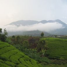
Mount Hutapanjang is a stratovolcano in Sumatra that rises to about 2000 meters with a distinctive cone shape built from hardened lava and volcanic rock. The mountain displays the layered structure typical of stratovolcanoes, with materials accumulated from successive eruptions.

The mountain formed through repeated eruptions during the Holocene period, shaping Sumatra's mountainous landscape. This ongoing volcanic activity created the ridge structures that define the island's geography.

Local communities refer to the mountain using the prefix 'Gunung', a naming practice that reflects how important mountains are in regional identity. This way of speaking shows how people see these peaks as central to where they live and who they are.

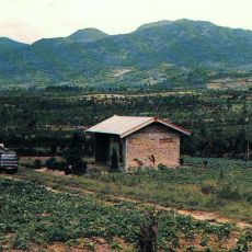
The mountain sits within an area of significant volcanic activity, part of Indonesia's network of monitored volcanoes. Visitors should check local conditions before exploring and be aware of hazards common to volcanic terrain.

The mountain sits within the Pacific Ring of Fire, a zone where tectonic plate movements continuously reshape the landscape. This location makes it a key example of the geological forces that have built the Southeast Asian archipelago.

The community of curious travelers

AroundUs brings together thousands of curated places, local tips, and hidden gems, enriched daily by 60,000 contributors worldwide.

Start exploring
Elevation above the sea
2,021 m
GPS coordinates
-2.33000,101.60000
Latest update
December 14, 2025 18:42
« Mount Hutapanjang - Stratovolcano in Sumatra, Indonesia » is provided by Around Us (aroundus.com). Images and texts are derived from Wikimedia project under a Creative Commons license. You are allowed to copy, distribute, and modify copies of this page, under the conditions set by the license, as long as this note is clearly visible.

Discover hidden gems everywhere you go!

From secret cafés to breathtaking viewpoints, skip the crowded tourist spots and find places that match your style. Our app makes it easy with voice search, smart filtering, route optimization, and insider tips from travelers worldwide. Download now for the complete mobile experience.

Around Us App Screenshot

A unique approach to discovering new places

Le Figaro

All the places worth exploring

France Info

A tailor-made excursion in just a few clicks

20 Minutes

Around Us
Travel Guide & Maps
Download

Send to your phone

QR Code
1

Open the camera app on your mobile.

2

Point at the QR code with your camera. A notification will appear.

3

Tap the notification to open the link.