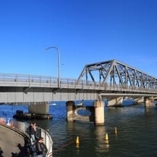
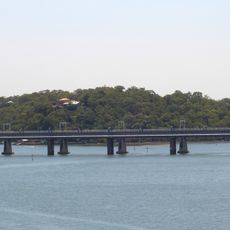
Captain Cook Bridge, New South Wales, Road bridge in southern Sydney, Australia
The Captain Cook Bridge is a precast prestressed concrete girder bridge carrying Rocky Point Road at Sans Souci to Taren Point Road at Taren Point. It has seven spans totalling 475 metres, a 506-metre deck 27.5 metres wide, six traffic lanes and two shared bicycle and pedestrian paths. Its foundations reach 67 metres down to sandstone beneath the Georges River, near its mouth at Botany Bay.
The bridge replaced a ferry service that operated between Sans Souci and Taren Point from 1911, followed by a motorized punt service in 1916. This crossing became a key infrastructure link connecting the two sides of the river with a permanent structure.
The bridge takes its name from Captain James Cook, who landed at Kurnell on 29 April 1770 during his first voyage aboard the Endeavour. The naming ties the crossing to that landing site, which lies near the river mouth the bridge spans.
The bridge maintains an 80 kilometer per hour speed limit and experiences heavy traffic during peak hours. Both drivers and cyclists find dedicated routes, allowing safe passage across the river.
The Captain Cook Bridge is the only section of the planned F6 Freeway ever built in the Sydney metropolitan area; the other completed stretches lie between Waterfall and Bulli Tops and between Gwynneville and Yallah. On the southern approach the two carriageways diverge, leaving room for a future interchange to carry freeway traffic to and from the bridge.
The community of curious travelers
AroundUs brings together thousands of curated places, local tips, and hidden gems, enriched daily by 94,410 contributors worldwide.