Chest opened
+${chestReward.xp} XP
Explorer
NOUVEAU ×${chestReward.collectible.quantity}
tapez pour fermer
Chest locked

Open chests in the app

Around Us is built for your phone — chests unlock when you walk, explore and capture nearby places.

Enable Location

We need your location to show you interesting places around you

Discover nearby places

Find interesting locations and hidden gems around you

Precise directions

Get accurate directions and distances to places

Your location is never shared with other users. It's only used when you tap the location button.

Lualualei VLF transmitter

Log in to your account

Start exploring — it's free

Trusted by 72,993 travelers worldwide

Continue with Google
Continue with Apple
or

We will send you a code to connect

By continuing, you accept our Terms and Conditions and our Privacy Policy

Check your inbox

We've sent a pincode in your inbox. Please enter the code below.

Lualualei VLF transmitter
Discussion Reviews 1 Photos
18.9k Popularity

Lualualei VLF transmitter, Military radio transmitter in Honolulu County, United States.

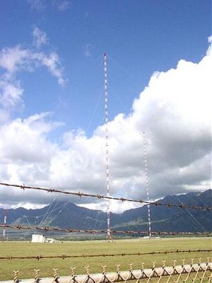
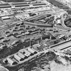
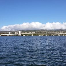
The Lualualei VLF transmitter is a naval radio facility in Hawaii consisting of two tall guyed masts rising more than 450 meters into the air. The masts are linked by an overhead cable system designed to send signals to submarines across the Pacific Ocean.

The facility was built in 1972 and represented a major leap forward in military communication technology for American Pacific operations. It became part of a broader effort to improve contact with submarines operating at depth.

The transmitter represents the evolution of naval communication methods, enabling direct contact with submerged submarines through very low frequency radio signals.

The two masts are visible from several vantage points in the area and form an unusual landmark on the landscape. The site has limited public access since it remains an active military installation.

The transmitter uses extremely low frequencies that can penetrate through the ocean and reach submarines where ordinary radio waves cannot reach. This allows communication across vast distances that would be impossible with standard radio technology.

The community of curious travelers

AroundUs brings together thousands of curated places, local tips, and hidden gems, enriched daily by 60,000 contributors worldwide.

Start exploring
Location
Inception
1972
Height
458.11 m
GPS coordinates
21.42000,-158.14800
Latest update
December 7, 2025 10:08
Around this place
USS Missouri
United States of America

USS Missouri

21.2 km
Aloha Stadium
United States of America

Aloha Stadium

23.2 km
Naval Station Pearl Harbor
United States of America

Naval Station Pearl Harbor

22.6 km
Wheeler Army Airfield
United States of America

Wheeler Army Airfield

13 km
Waimea Valley
United States of America

Waimea Valley

25.8 km
Kaena Point Satellite Tracking Station
United States of America

Kaena Point Satellite Tracking Station

18.4 km
USS Bowfin
United States of America

USS Bowfin

22.4 km
Kaʻala
United States of America

Kaʻala

9.8 km
Admiral Clarey Bridge
United States of America

Admiral Clarey Bridge

21.9 km
Pacific Aviation Museum Pearl Harbor
United States of America

Pacific Aviation Museum Pearl Harbor

20.4 km
Fort Kamehameha
United States of America

Fort Kamehameha

22.3 km
Kukaniloko Birth Site
United States of America

Kukaniloko Birth Site

14.9 km
Wet'n'Wild Hawaii
United States of America

Wet'n'Wild Hawaii

11.3 km
Commander in Chief Pacific Fleet Headquarters
United States of America

Commander in Chief Pacific Fleet Headquarters

22.9 km
Hawaiian Railway Society
United States of America

Hawaiian Railway Society

14.4 km
Submarine Memorial Chapel
United States of America

Submarine Memorial Chapel

22.5 km
Wahiawa Botanical Garden
United States of America

Wahiawa Botanical Garden

16.4 km
Barbers Point Light
United States of America

Barbers Point Light

14.4 km
Aloha Jewish Chapel
United States of America

Aloha Jewish Chapel

23.2 km
Keaīwa Heiau State Recreation Area
United States of America

Keaīwa Heiau State Recreation Area

25.8 km
Waimalu Shopping Center
United States of America

Waimalu Shopping Center

20.9 km
Tropic Lightning Museum
United States of America

Tropic Lightning Museum

12.8 km
Waipahu Theater
United States of America

Waipahu Theater

15.2 km
Sharkey Theater
United States of America

Sharkey Theater

22.6 km
Honolulu Magnetic Observatory
United States of America

Honolulu Magnetic Observatory

19.2 km
Waialua Public Library
United States of America

Waialua Public Library

17.4 km
Pineapple Garden Maze
United States of America

Pineapple Garden Maze

16.3 km
The Arrival of Filipino Plantation Workers in Hawaii historical marker
United States of America

The Arrival of Filipino Plantation Workers in Hawaii historical marker

15.1 km
Show the full map
Reviews
Share your experience

No review yet

Discussions
Start a discussion...

No discussion yet

« Lualualei VLF transmitter - Military radio transmitter in Honolulu County, United States » is provided by Around Us (aroundus.com). Images and texts are derived from Wikimedia project under a Creative Commons license. You are allowed to copy, distribute, and modify copies of this page, under the conditions set by the license, as long as this note is clearly visible.

Discover hidden gems everywhere you go!

From secret cafés to breathtaking viewpoints, skip the crowded tourist spots and find places that match your style. Our app makes it easy with voice search, smart filtering, route optimization, and insider tips from travelers worldwide. Download now for the complete mobile experience.

Around Us App Screenshot

A unique approach to discovering new places

Le Figaro

All the places worth exploring

France Info

A tailor-made excursion in just a few clicks

20 Minutes

Around Us
Travel Guide & Maps
Download

Send to your phone

QR Code
1

Open the camera app on your mobile.

2

Point at the QR code with your camera. A notification will appear.

3

Tap the notification to open the link.