Chest opened
+${chestReward.xp} XP
Explorer
NOUVEAU ×${chestReward.collectible.quantity}
tapez pour fermer
Chest locked

Open chests in the app

Around Us is built for your phone — chests unlock when you walk, explore and capture nearby places.

Enable Location

We need your location to show you interesting places around you

Discover nearby places

Find interesting locations and hidden gems around you

Precise directions

Get accurate directions and distances to places

Your location is never shared with other users. It's only used when you tap the location button.

Turnagain Arm

Log in to your account

Start exploring — it's free

Trusted by 72,882 travelers worldwide

Continue with Google
Continue with Apple
or

We will send you a code to connect

By continuing, you accept our Terms and Conditions and our Privacy Policy

Check your inbox

We've sent a pincode in your inbox. Please enter the code below.

Turnagain Arm
Discussion Reviews 1 Photos
20k Popularity

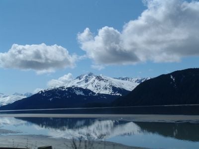
Turnagain Arm, Marine inlet in south-central Alaska, United States

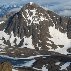
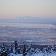
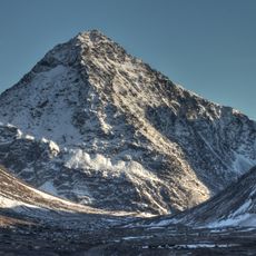
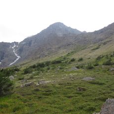
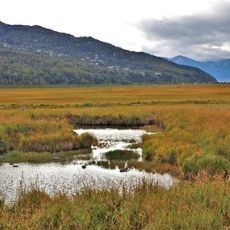
Turnagain Arm is a marine inlet in south-central Alaska that extends between the Chugach Mountains and the Kenai Peninsula. Its deep waters support maritime activity, and the shoreline is marked by mountain slopes and glacial streams.

British explorer James Cook mapped this inlet in 1778 during his expedition and named it after having to turn back when realizing it led nowhere. This early exploration shaped European understanding of Alaska's geography.

The Dena'ina people called this inlet Tutl'uh and have maintained fishing and hunting practices along its shores for centuries. Visitors can still sense the importance of these traditions when traveling through the region today.

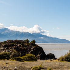
The Seward Highway runs along the inlet and provides multiple viewing points to observe its extreme tidal changes throughout the day. Visitors can easily access the shoreline from pull-offs and rest areas along this main route without needing special equipment.

This inlet generates a tidal bore, a rare phenomenon where water surges inland creating waves that move against the current when tides shift. This striking event can be viewed from the highway and draws visitors interested in witnessing this natural power.

The community of curious travelers

AroundUs brings together thousands of curated places, local tips, and hidden gems, enriched daily by 60,000 contributors worldwide.

Start exploring
Location
Part of
Cook Inlet
GPS coordinates
60.98720,-149.79500
Latest update
December 7, 2025 10:06
Around this place
Conoco-Phillips Building
United States of America

Conoco-Phillips Building

26 km
Alaska Zoo
United States of America

Alaska Zoo

15.3 km
Flattop Mountain
United States of America

Flattop Mountain

13.3 km
Anchorage Museum
United States of America

Anchorage Museum

25.9 km
Kincaid Park
United States of America

Kincaid Park

23.3 km
Robert B. Atwood Building
United States of America

Robert B. Atwood Building

25.9 km
Alaska Center for the Performing Arts
United States of America

Alaska Center for the Performing Arts

26.1 km
Our Lady of Guadalupe Co-Cathedral
United States of America

Our Lady of Guadalupe Co-Cathedral

23.4 km
Cathedral of the Holy Family
United States of America

Cathedral of the Holy Family

26.2 km
Beluga Point Site
United States of America

Beluga Point Site

5.8 km
Anchorage Alaska Temple
United States of America

Anchorage Alaska Temple

13 km
Alaska Botanical Garden
United States of America

Alaska Botanical Garden

21.2 km
Alaska Aviation Museum
United States of America

Alaska Aviation Museum

23.4 km
McKinley Tower Apartments
United States of America

McKinley Tower Apartments

26.1 km
UAA/APU Consortium Library
United States of America

UAA/APU Consortium Library

22.7 km
H2Oasis Indoor Waterpark
United States of America

H2Oasis Indoor Waterpark

15.3 km
Anchorage Memorial Park
United States of America

Anchorage Memorial Park

25.8 km
South Yuyanq’ Ch’ex
United States of America

South Yuyanq’ Ch’ex

12.8 km
Pilgrim 100-B N709Y
United States of America

Pilgrim 100-B N709Y

23.2 km
Chester Creek
United States of America

Chester Creek

24.4 km
North Yuyanq’ Ch’ex
United States of America

North Yuyanq’ Ch’ex

13.8 km
Ptarmigan Peak
United States of America

Ptarmigan Peak

13 km
KENI Radio Building
United States of America

KENI Radio Building

25.3 km
Anchorage Coastal Wildlife Refuge
United States of America

Anchorage Coastal Wildlife Refuge

14.2 km
Potter Section House
United States of America

Potter Section House

7.2 km
Oscar Gill House
United States of America

Oscar Gill House

25.9 km
Atwood Campus Center
United States of America

Atwood Campus Center

22.6 km
Loussac-Sogn Building
United States of America

Loussac-Sogn Building

26.2 km
Show the full map
Reviews
Share your experience

No review yet

Discussions
Start a discussion...

No discussion yet

« Turnagain Arm - Marine inlet in south-central Alaska, United States » is provided by Around Us (aroundus.com). Images and texts are derived from Wikimedia project under a Creative Commons license. You are allowed to copy, distribute, and modify copies of this page, under the conditions set by the license, as long as this note is clearly visible.

Discover hidden gems everywhere you go!

From secret cafés to breathtaking viewpoints, skip the crowded tourist spots and find places that match your style. Our app makes it easy with voice search, smart filtering, route optimization, and insider tips from travelers worldwide. Download now for the complete mobile experience.

Around Us App Screenshot

A unique approach to discovering new places

Le Figaro

All the places worth exploring

France Info

A tailor-made excursion in just a few clicks

20 Minutes

Around Us
Travel Guide & Maps
Download

Send to your phone

QR Code
1

Open the camera app on your mobile.

2

Point at the QR code with your camera. A notification will appear.

3

Tap the notification to open the link.