Enable Location

We need your location to show you interesting places around you

Discover nearby places

Find interesting locations and hidden gems around you

Precise directions

Get accurate directions and distances to places

Your location is never shared with other users. It's only used when you tap the location button.

San Vicente Reservoir

Log in to your account

Start exploring — it's free

Trusted by 62,169 travelers worldwide

Continue with Google
Continue with Apple
or

We will send you a code to connect

By continuing, you accept our Terms and Conditions and our Privacy Policy

Check your inbox

We've sent a pincode in your inbox. Please enter the code below.

San Vicente Reservoir

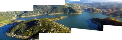
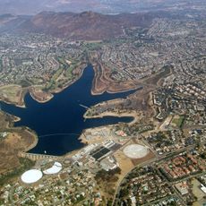
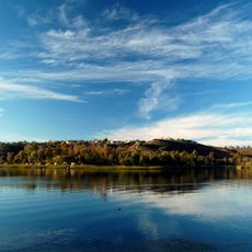
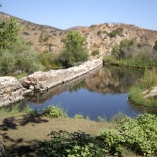
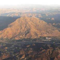
San Vicente Reservoir, body of water

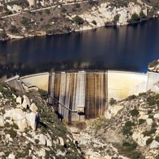
San Vicente Reservoir is a large body of water in California with steep banks and deep water that reaches over 300 feet when full. The site has picnic areas, restrooms, and boat launch ramps, with water levels that vary seasonally.

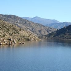
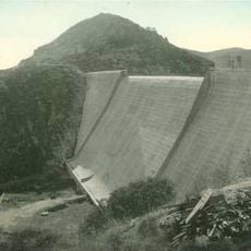
The dam was originally built in 1943 to store water for the region. A major project starting in 2009 raised the dam over 100 feet to increase storage capacity by more than 150,000 acre-feet.

The reservoir serves as a gathering place where locals fish, boat, and picnic together, especially on weekends. The simple facilities and open water create a space for everyday outdoor activities that bring people together.

Entry costs a small fee, and visitors should follow local rules such as no swimming and no dogs in the water. The best time to visit is on warm days when most activities are open and the site is well-maintained.

The water depth can exceed 300 feet, making it one of the deeper reservoirs in Southern California. The lake was strategically expanded to ensure water supply during emergencies or drought periods.

The community of curious travelers

AroundUs brings together thousands of curated places, local tips, and hidden gems, enriched daily by 60,000 contributors worldwide.

Start exploring
Location
GPS coordinates
32.91230,-116.92500
Latest update
February 7, 2026 11:01
Around this place
Potato Chip Rock
United States of America

Potato Chip Rock

11.7 km
Cowles Mountain
United States of America

Cowles Mountain

14.9 km
Mission Trails Regional Park
United States of America

Mission Trails Regional Park

15.1 km
Blackjack Hall of Fame
United States of America

Blackjack Hall of Fame

5.3 km
Barona Casino
United States of America

Barona Casino

5.7 km
Flying Leatherneck Aviation Museum
United States of America

Flying Leatherneck Aviation Museum

20.1 km
Skyline Church
United States of America

Skyline Church

19.2 km
Lake Murray
United States of America

Lake Murray

17.9 km
Miramar Reservoir
United States of America

Miramar Reservoir

16.2 km
Black Mountain Open Space Park
United States of America

Black Mountain Open Space Park

18.9 km
El Capitan Reservoir
United States of America

El Capitan Reservoir

11.2 km
El Cajon Mountain
United States of America

El Cajon Mountain

9.8 km
Museum of Creation and Earth History
United States of America

Museum of Creation and Earth History

8.1 km
Old Mission Dam
United States of America

Old Mission Dam

13.7 km
San Vicente Dam
United States of America

San Vicente Dam

94 m
Classic Rotors Museum
United States of America

Classic Rotors Museum

14.2 km
Rancho Santa Maria de Los Peñasquitos
United States of America

Rancho Santa Maria de Los Peñasquitos

19.1 km
Viejas Mountain
United States of America

Viejas Mountain

19.5 km
Loveland Dam
United States of America

Loveland Dam

19 km
Edgemoor Farm Dairy Barn
United States of America

Edgemoor Farm Dairy Barn

8.7 km
Santee Boulders
United States of America

Santee Boulders

11.3 km
McGinty Mountain
United States of America

McGinty Mountain

18.8 km
Creation & Earth History Museum & Bookstore
United States of America

Creation & Earth History Museum & Bookstore

8.1 km
Jardín Ahorrador de Agua en el Cuyamaca College
United States of America

Jardín Ahorrador de Agua en el Cuyamaca College

18.7 km
San Vicente Golf Club
United States of America

San Vicente Golf Club

14.8 km
Museum
United States of America

Museum

18.9 km
La Mesa Library
United States of America

La Mesa Library

18.7 km
Ramona Grasslands Preserve
United States of America

Ramona Grasslands Preserve

14.8 km
Show the full map
« San Vicente Reservoir - body of water » is provided by Around Us (aroundus.com). Images and texts are derived from Wikimedia project under a Creative Commons license. You are allowed to copy, distribute, and modify copies of this page, under the conditions set by the license, as long as this note is clearly visible.

Discover hidden gems everywhere you go!

From secret cafés to breathtaking viewpoints, skip the crowded tourist spots and find places that match your style. Our app makes it easy with voice search, smart filtering, route optimization, and insider tips from travelers worldwide. Download now for the complete mobile experience.

Around Us App Screenshot

A unique approach to discovering new places

Le Figaro

All the places worth exploring

France Info

A tailor-made excursion in just a few clicks

20 Minutes

Around Us
Travel Guide & Maps
Download

Send to your phone

QR Code
1

Open the camera app on your mobile.

2

Point at the QR code with your camera. A notification will appear.

3

Tap the notification to open the link.