Enable Location

We need your location to show you interesting places around you

Discover nearby places

Find interesting locations and hidden gems around you

Precise directions

Get accurate directions and distances to places

Your location is never shared with other users. It's only used when you tap the location button.

El Capitan Reservoir

Log in to your account

Start exploring — it's free

Trusted by 62,163 travelers worldwide

Continue with Google
Continue with Apple
or

We will send you a code to connect

By continuing, you accept our Terms and Conditions and our Privacy Policy

Check your inbox

We've sent a pincode in your inbox. Please enter the code below.

El Capitan Reservoir

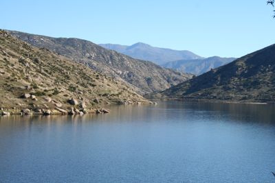
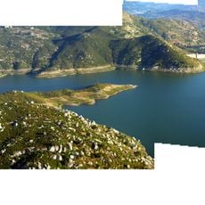
El Capitan Reservoir, reservoir in San Diego County, California

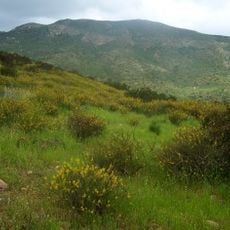
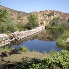
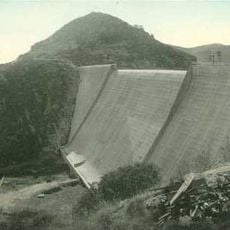
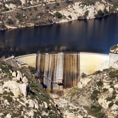
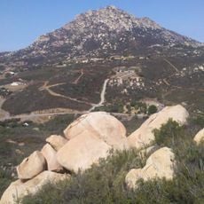
El Capitan Reservoir is a large water storage facility in the Cuyamaca Mountains about 30 miles northeast of San Diego, held back by a concrete dam built over 230 feet tall. The water extends for about 22 miles along the shoreline, serving both as a drinking water source for the city and as a location for fishing, kayaking, and small boat activities.

The dam was completed in 1934 as part of a water supply project for San Diego and was originally the city's largest reservoir. Following a major earthquake in 1971, safety measures were upgraded and water level limits were imposed to prevent potential hazards.

The reservoir sits on land once inhabited by the Kumeyaay people, a Native American tribe whose presence shaped this region long before the dam was built. Today, it represents how communities manage natural resources while respecting the landscape and its history.

The reservoir is open for day visits to fish and paddle small boats, but is closed on Wednesdays, Thursdays, and the first Friday of each month. Entry fees apply, and visitors should know that camping is not permitted at the water itself, though nearby alternatives like Lake Jennings are available for overnight stays.

The reservoir permits only small boats like kayaks and canoes while prohibiting water skiing, wakeboarding, and jet skis to keep drinking water clean and safe. This restriction shows how the city balances water quality protection with recreational access.

The community of curious travelers

AroundUs brings together thousands of curated places, local tips, and hidden gems, enriched daily by 60,000 contributors worldwide.

Start exploring
Location
GPS coordinates
32.88556,-116.80917
Latest update
February 7, 2026 11:00
Around this place
Potato Chip Rock
United States of America

Potato Chip Rock

20.7 km
Cowles Mountain
United States of America

Cowles Mountain

22.3 km
Cuyamaca Rancho State Park
United States of America

Cuyamaca Rancho State Park

23 km
Mission Trails Regional Park
United States of America

Mission Trails Regional Park

23.6 km
Blackjack Hall of Fame
United States of America

Blackjack Hall of Fame

8.5 km
Barona Casino
United States of America

Barona Casino

8.6 km
Viejas Casino
United States of America

Viejas Casino

10.9 km
Skyline Church
United States of America

Skyline Church

20.9 km
Cuyamaca Peak
United States of America

Cuyamaca Peak

20.1 km
San Vicente Reservoir
United States of America

San Vicente Reservoir

11.2 km
El Cajon Mountain
United States of America

El Cajon Mountain

3.4 km
Museum of Creation and Earth History
United States of America

Museum of Creation and Earth History

14.8 km
Old Mission Dam
United States of America

Old Mission Dam

22.5 km
San Vicente Dam
United States of America

San Vicente Dam

11.1 km
Classic Rotors Museum
United States of America

Classic Rotors Museum

19.8 km
Viejas Mountain
United States of America

Viejas Mountain

8.2 km
Hubert H. Bancroft Ranch House
United States of America

Hubert H. Bancroft Ranch House

23.6 km
Loveland Dam
United States of America

Loveland Dam

11.6 km
Edgemoor Farm Dairy Barn
United States of America

Edgemoor Farm Dairy Barn

15.7 km
Lyons Peak
United States of America

Lyons Peak

20.9 km
Santee Boulders
United States of America

Santee Boulders

20.2 km
McGinty Mountain
United States of America

McGinty Mountain

15.6 km
Creation & Earth History Museum & Bookstore
United States of America

Creation & Earth History Museum & Bookstore

14.8 km
Jardín Ahorrador de Agua en el Cuyamaca College
United States of America

Jardín Ahorrador de Agua en el Cuyamaca College

19.9 km
San Vicente Golf Club
United States of America

San Vicente Golf Club

12.9 km
Museum
United States of America

Museum

20.1 km
La Mesa Library
United States of America

La Mesa Library

24 km
Ramona Grasslands Preserve
United States of America

Ramona Grasslands Preserve

22 km
Show the full map
« El Capitan Reservoir - reservoir in San Diego County, California » is provided by Around Us (aroundus.com). Images and texts are derived from Wikimedia project under a Creative Commons license. You are allowed to copy, distribute, and modify copies of this page, under the conditions set by the license, as long as this note is clearly visible.

Discover hidden gems everywhere you go!

From secret cafés to breathtaking viewpoints, skip the crowded tourist spots and find places that match your style. Our app makes it easy with voice search, smart filtering, route optimization, and insider tips from travelers worldwide. Download now for the complete mobile experience.

Around Us App Screenshot

A unique approach to discovering new places

Le Figaro

All the places worth exploring

France Info

A tailor-made excursion in just a few clicks

20 Minutes

Around Us
Travel Guide & Maps
Download

Send to your phone

QR Code
1

Open the camera app on your mobile.

2

Point at the QR code with your camera. A notification will appear.

3

Tap the notification to open the link.