Willcox Playa, National Natural Landmark dry lake in Cochise County, Arizona, United States
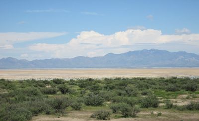
Willcox Playa is a large dry lake bed in the Sonoran Desert with a completely flat surface that occasionally accumulates water during heavy rains. The terrain spreads across open ground with minimal vegetation, creating a stark and exposed landscape.
During the Pleistocene era, this area held Lake Cochise, a substantial body of water that eventually dried up over thousands of years. The gradual evaporation of this ancient lake shaped the landscape into what visitors see today.
The playa serves as a winter stopover for sandhill cranes, with thousands of these tall birds gathering here to feed and rest. Local birdwatchers and nature observers regularly visit to watch these seasonal visitors in their natural habitat.
You can reach the site via state highways near the town of Willcox, with access points scattered around the perimeter. Some areas remain off-limits to visitors because of military operations in the region.
The dry lake bed is home to one of the densest populations of tiger beetles in the country, including a species found nowhere else. These small predatory insects have adapted to thrive on bare ground and sand, making them a remarkable feature of this habitat.
Location: Cochise County
GPS coordinates: 32.14100,-109.84800
Latest update: December 8, 2025 19:41
The Thing?
20.1 km
Fort Bowie
38.8 km
Texas Canyon
24.5 km
Sierra Bonita Ranch
44.9 km
Amerind Foundation
24.2 km
Faraway Ranch Historic District
47.1 km
Gleeson Jail
45.6 km
Cochise Hotel
8.1 km
Rex Allen Arizona Cowboy Museum and Willcox Cowboy Hall of Fame
12.5 kmBonita Canyon
48.7 kmMae West Peaks
26.3 km
J.H. Smith Grocery Store and Filling Station
21.9 km
Chiricahua National Monument Historic Designed Landscape
51.3 kmLime Peak
23.5 kmOur Lady of Victory Catholic Church
26.5 km
Pearce General Store
26.5 km
Benson Railroad Historic District
46.3 km
Johnson-Tillotson House
12.6 km
John Gung'l House
12.5 km
Benjamin E. Briscoe House
13 km
Fort Bowie National Historic Site
37.4 km
Bowie School District No. 14
39.5 km
Apache Powder Historic Residential District
46.8 km
San Pedro Golf Course
44.9 km
Fort Bowie Ranger Station & Visitor Center
38.8 km
Sugarloaf Mountain Lookout
51.3 km
Bonita Canyon Campground
48.7 km
San Pedro River Railroad Bridge
45.1 kmVisited this place? Tap the stars to rate it and share your experience / photos with the community! Try now! You can cancel it anytime.
Discover hidden gems everywhere you go!
From secret cafés to breathtaking viewpoints, skip the crowded tourist spots and find places that match your style. Our app makes it easy with voice search, smart filtering, route optimization, and insider tips from travelers worldwide. Download now for the complete mobile experience.
A unique approach to discovering new places❞
— Le Figaro
All the places worth exploring❞
— France Info
A tailor-made excursion in just a few clicks❞
— 20 Minutes