Enable Location

We need your location to show you interesting places around you

Discover nearby places

Find interesting locations and hidden gems around you

Precise directions

Get accurate directions and distances to places

Your location is never shared with other users. It's only used when you tap the location button.

Gleeson Jail

Log in to your account

Start exploring — it's free

Trusted by 61,953 travelers worldwide

Continue with Google
Continue with Apple
or

We will send you a code to connect

By continuing, you accept our Terms and Conditions and our Privacy Policy

Check your inbox

We've sent a pincode in your inbox. Please enter the code below.

Gleeson Jail

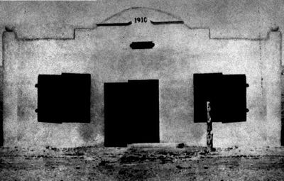
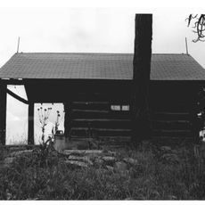
Gleeson Jail, Historic jail structure in Gleeson, United States.

Gleeson Jail is a concrete structure with two cells connected by a central cage and reinforced with railroad ties and steel bars throughout its walls. The design reflects the construction methods used in early jail facilities across the frontier region.

Built in 1910, this jail replaced an earlier wooden structure where prisoners had been chained to an oak tree. The construction marked a shift toward more formal detention methods in the territory.

The jail carries the mark of Deputy Wesley Wooten Cates, whose background as a Texas Ranger shaped local law enforcement practices. His vision for a permanent holding facility reflected the growing security needs of the frontier community during that era.

Plan your visit in advance, as regular access is limited and appointments should be arranged beforehand to ensure entry. Confirmation of availability and directions is recommended before making the trip.

A deliberately preserved section of the floor reveals the original railroad rails embedded in the building's construction. This exposed detail tells the story of the improvised building methods common on the frontier.

The community of curious travelers

AroundUs brings together thousands of curated places, local tips, and hidden gems, enriched daily by 60,000 contributors worldwide.

Start exploring
Location
GPS coordinates
31.73210,-109.82900
Latest update
December 13, 2025 12:41
Around this place
The Thing?
United States of America

The Thing?

44.3 km
Bird Cage Theatre
United States of America

Bird Cage Theatre

22.5 km
Texas Canyon
United States of America

Texas Canyon

43.2 km
Willcox Playa
United States of America

Willcox Playa

45.6 km
Schieffelin Hall
United States of America

Schieffelin Hall

22.5 km
Tombstone Courthouse
United States of America

Tombstone Courthouse

22.8 km
Murray Springs Clovis Site
United States of America

Murray Springs Clovis Site

37.8 km
San Pedro Riparian National Conservation Area
United States of America

San Pedro Riparian National Conservation Area

33.1 km
Tombstone Historic District
United States of America

Tombstone Historic District

22.6 km
Presidio Santa Cruz de Terrenate
United States of America

Presidio Santa Cruz de Terrenate

35.4 km
Amerind Foundation
United States of America

Amerind Foundation

42.1 km
Leslie Canyon National Wildlife Refuge
United States of America

Leslie Canyon National Wildlife Refuge

34 km
Bisbee Historic District
United States of America

Bisbee Historic District

33.2 km
Hereford Arizona Observatory
United States of America

Hereford Arizona Observatory

49.7 km
Rucker Canyon
United States of America

Rucker Canyon

37.8 km
Phelps Dodge General Office Building
United States of America

Phelps Dodge General Office Building

33.3 km
St. Patrick's Roman Catholic Church
United States of America

St. Patrick's Roman Catholic Church

33.2 km
United States of America

Mae West Peaks

49.5 km
United States of America

Lime Peak

49.2 km
Bisbee Residential Historic District
United States of America

Bisbee Residential Historic District

33.3 km
Bisbee Woman's Club Clubhouse
United States of America

Bisbee Woman's Club Clubhouse

33.6 km
United States of America

Our Lady of Victory Catholic Church

19.2 km
Pearce General Store
United States of America

Pearce General Store

19.2 km
Monte Vista Lookout Cabin
United States of America

Monte Vista Lookout Cabin

49.7 km
Castle Rock
United States of America

Castle Rock

33.3 km
Hereford Road Bridge
United States of America

Hereford Road Bridge

42 km
Fairbank Railroad Bridge
United States of America

Fairbank Railroad Bridge

34.7 km
Cochise Trail
United States of America

Cochise Trail

25.7 km
Show the full map
« Gleeson Jail - Historic jail structure in Gleeson, United States » is provided by Around Us (aroundus.com). Images and texts are derived from Wikimedia project under a Creative Commons license. You are allowed to copy, distribute, and modify copies of this page, under the conditions set by the license, as long as this note is clearly visible.

Discover hidden gems everywhere you go!

From secret cafés to breathtaking viewpoints, skip the crowded tourist spots and find places that match your style. Our app makes it easy with voice search, smart filtering, route optimization, and insider tips from travelers worldwide. Download now for the complete mobile experience.

Around Us App Screenshot

A unique approach to discovering new places

Le Figaro

All the places worth exploring

France Info

A tailor-made excursion in just a few clicks

20 Minutes

Around Us
Travel Guide & Maps
Download

Send to your phone

QR Code
1

Open the camera app on your mobile.

2

Point at the QR code with your camera. A notification will appear.

3

Tap the notification to open the link.