Enable Location

We need your location to show you interesting places around you

Discover nearby places

Find interesting locations and hidden gems around you

Precise directions

Get accurate directions and distances to places

Your location is never shared with other users. It's only used when you tap the location button.

San Carlos Lake

Log in to your account

Start exploring — it's free

Trusted by 62,469 travelers worldwide

Continue with Google
Continue with Apple
or

We will send you a code to connect

By continuing, you accept our Terms and Conditions and our Privacy Policy

Check your inbox

We've sent a pincode in your inbox. Please enter the code below.

San Carlos Lake

San Carlos Lake, reservoir in Arizona, United States

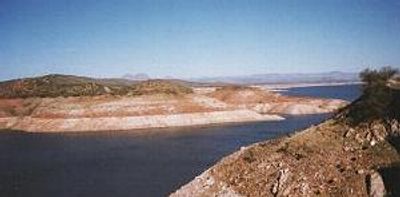
San Carlos Lake is a large reservoir with a long shoreline that winds through rocky desert terrain, lined with cacti and mountains. The clear blue water is surrounded by rugged hills that are part of the Gila and Mescal mountain ranges.

The lake was created by building Coolidge Dam, which was dedicated in 1930 by President Calvin Coolidge and features a distinctive egg-crate style of construction. After decades of water accumulation, the basin eventually filled and has since supported farming irrigation in downstream areas.

The lake sits within San Carlos Apache tribal lands, and visitors experience the area as a place governed by tribal rules and customs. The local communities show deep respect for the land and water, maintaining it for both present and future generations.

The lake is best reached from Highway 70, and visitors should know that all activities like fishing, camping, and hiking require a permit from the local tribal authority. The roads around the lake have some uneven sections, so a vehicle with good ground clearance is recommended.

Water levels at this reservoir change dramatically with seasons and water availability, causing fish populations to fluctuate, especially when levels drop significantly. Visitors can spot interesting rock formations and shallow brush-lined areas at popular fishing spots like Old Government and Catfish Bay that create excellent hiding places for fish.

The community of curious travelers

AroundUs brings together thousands of curated places, local tips, and hidden gems, enriched daily by 60,000 contributors worldwide.

Start exploring
Location
Location
Location
GPS coordinates
33.20018,-110.42095
Latest update
February 7, 2026 11:01
Around this place
Biosphere 2
United States of America

Biosphere 2

80 km
Vatican Advanced Technology Telescope
United States of America

Vatican Advanced Technology Telescope

74.3 km
Salt River Canyon Wilderness
United States of America

Salt River Canyon Wilderness

62.4 km
Camp Grant
United States of America

Camp Grant

48.3 km
Boyce Thompson Arboretum
United States of America

Boyce Thompson Arboretum

69.2 km
United States of America

Picketpost Mountain

68.9 km
Oracle State Park
United States of America

Oracle State Park

69.4 km
Besh-Ba-Gowah
United States of America

Besh-Ba-Gowah

38.4 km
Galiuro Wilderness
United States of America

Galiuro Wilderness

68.8 km
Acadia Ranch
United States of America

Acadia Ranch

73.2 km
Globe Downtown Historic District
United States of America

Globe Downtown Historic District

40.2 km
La Casa del High Jinks
United States of America

La Casa del High Jinks

76 km
Gila County Courthouse
United States of America

Gila County Courthouse

40.4 km
Our Lady of the Blessed Sacrament Church
United States of America

Our Lady of the Blessed Sacrament Church

47.6 km
Holy Angels Church
United States of America

Holy Angels Church

40.2 km
Gila Valley Bank and Trust Building
United States of America

Gila Valley Bank and Trust Building

39.6 km
Elks Building
United States of America

Elks Building

39.7 km
Winkelman Bridge
United States of America

Winkelman Bridge

40.5 km
Miami Community Church
United States of America

Miami Community Church

47.1 km
United States Post Office and Courthouse–Globe Main
United States of America

United States Post Office and Courthouse–Globe Main

39.7 km
Globe Ranger Station
United States of America

Globe Ranger Station

38 km
Columbine Work Station
United States of America

Columbine Work Station

72.9 km
Besh-Ba-Gowah Museum
United States of America

Besh-Ba-Gowah Museum

38.5 km
Bullion Plaza Cultural Center and Museum
United States of America

Bullion Plaza Cultural Center and Museum

47.8 km
Gila County Historical Museum
United States of America

Gila County Historical Museum

41.9 km
Coolidge Dam
United States of America

Coolidge Dam

10.3 km
Pinto Creek Bridge
United States of America

Pinto Creek Bridge

53 km
Mammoth Wash Trestle Bridge
United States of America

Mammoth Wash Trestle Bridge

59.7 km
Show the full map
« San Carlos Lake - reservoir in Arizona, United States » is provided by Around Us (aroundus.com). Images and texts are derived from Wikimedia project under a Creative Commons license. You are allowed to copy, distribute, and modify copies of this page, under the conditions set by the license, as long as this note is clearly visible.

Discover hidden gems everywhere you go!

From secret cafés to breathtaking viewpoints, skip the crowded tourist spots and find places that match your style. Our app makes it easy with voice search, smart filtering, route optimization, and insider tips from travelers worldwide. Download now for the complete mobile experience.

Around Us App Screenshot

A unique approach to discovering new places

Le Figaro

All the places worth exploring

France Info

A tailor-made excursion in just a few clicks

20 Minutes

Around Us
Travel Guide & Maps
Download

Send to your phone

QR Code
1

Open the camera app on your mobile.

2

Point at the QR code with your camera. A notification will appear.

3

Tap the notification to open the link.