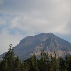
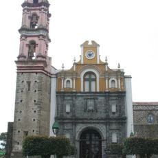
Malinche, Dormant volcano in Tlaxcala and Puebla, Mexico.
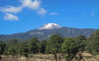
La Malinche, also called Matlalcueitl, is a dormant volcano on the border between Tlaxcala and Puebla that rises to 4,461 meters above sea level. The mountain features multiple side peaks and transitions from dense forests at its base to rocky surfaces near the top.
The volcano formed over 30 million years ago during the Paleogene period and shaped the landscape between the states. Its last eruption occurred roughly 3,100 years ago, ending the active phase of the mountain.
The Tlaxcaltecs named the peak Matlalcueitl, meaning Lady of the Blue Skirt, connecting it to their rain and song deity. This name still resonates in the reverence many visitors show when approaching the summit.
The national park offers accommodation in cabins at 3,080 meters elevation, from where hiking trails lead through different climate zones to the summit. The ascent passes through changing vegetation levels and requires good physical preparation for the thin air at altitude.
A misunderstanding in 1968 led local residents to attack university climbers, marking a dark chapter in the modern history of the mountain. This incident is rarely mentioned today but remains part of the local memory.
Location: Tlaxcala
Elevation above the sea: 4,420 m
GPS coordinates: 19.23096,-98.03216
Latest update: December 17, 2025 08:38
Forts of Loreto and Guadalupe
25.3 km
Basílica de Ocotlán
22.7 km
La Malinche National Park
2.4 km
Our Lady of the Assumption Cathedral
23.5 km
Autódromo Miguel E. Abed
22.8 km
Estadio Tlahuicole
23.3 km
Tizatlán
22.9 km
Palacio de Gobierno de Tlaxcala
23.7 km
Parroquia de San José
23.8 km
Escalinatas de los héroes
24.1 km
Ocotelulco
24.1 km
Parque nacional Xicoténcatl
23.7 km
Monumento a Tlahuicole
23.4 km
Ex Convento de Santa María de la Concepción Atlihuetzia
21.9 kmSan Gabriel Cuauhtla
23 km
Teatro Xicohténcatl
23.6 km
Centro Cultural Universitario
23.4 km
Museo Taurino de Huamantla
15 km
Parque ecológico Los Ladrillos
24.1 km
Cerro de la Luna
20.7 km
Monumento a Domingo Arenas
22 km
Holy Cross church, Santa Cruz Tlaxcala, Tlaxcala
18.5 km
Cerrito del Chiquihuite
22.7 km
Centro Cultural de Zacatelco
21.9 km
Zona Arqueológica de Ocotelulco
24 km
Estación de Santa Cruz del Ferrocarril Mexicano
18.9 km
Centro de las Artes Tlaxcala
23.2 km
Parroquia de Nuestra Señora del Rayo, Puebla, Pue.
25.3 kmVisited this place? Tap the stars to rate it and share your experience / photos with the community! Try now! You can cancel it anytime.
Discover hidden gems everywhere you go!
From secret cafés to breathtaking viewpoints, skip the crowded tourist spots and find places that match your style. Our app makes it easy with voice search, smart filtering, route optimization, and insider tips from travelers worldwide. Download now for the complete mobile experience.
A unique approach to discovering new places❞
— Le Figaro
All the places worth exploring❞
— France Info
A tailor-made excursion in just a few clicks❞
— 20 Minutes