Chest opened
+${chestReward.xp} XP
Explorer
NOUVEAU ×${chestReward.collectible.quantity}
tapez pour fermer
Chest locked

Open chests in the app

Around Us is built for your phone — chests unlock when you walk, explore and capture nearby places.

Enable Location

We need your location to show you interesting places around you

Discover nearby places

Find interesting locations and hidden gems around you

Precise directions

Get accurate directions and distances to places

Your location is never shared with other users. It's only used when you tap the location button.

Cerro del Bernal

Log in to your account

Start exploring — it's free

Trusted by 72,891 travelers worldwide

Continue with Google
Continue with Apple
or

We will send you a code to connect

By continuing, you accept our Terms and Conditions and our Privacy Policy

Check your inbox

We've sent a pincode in your inbox. Please enter the code below.

Cerro del Bernal
Discussion Reviews 1 Photos
12.3k Popularity

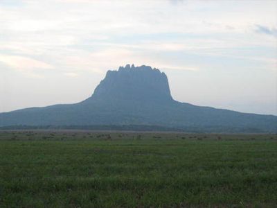
Cerro del Bernal, Mountain peak in González Municipality, Mexico

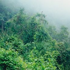
Cerro del Bernal is a distinctive mountain in González Municipality with an inverted cone shape, where the lower slopes are covered with tropical forest while the upper section rises as a steep rocky mass. The summit area features exposed stone with loose debris that requires caution when climbing to the top.

Tanchoy, a Huasteco settlement, once thrived near the mountain but declined during Spanish colonization in the 1500s. This early community represents the indigenous presence that shaped the region for centuries before European contact.

The mountain served as a home territory for Huasteco and Pison communities, who cultivated fruit orchards across its slopes over many generations. The land still shows traces of how these groups shaped and used the terrain for agriculture.

From the summit, visitors gain views of the Guayalejo river valley, nearby towns, and the Tampico-Mante highway stretching below. Wear sturdy footwear and bring water, as the tropical heat and humidity can be intense during a climb.

In the early 1900s, herders discovered sand deposits with high gold content in a stream flowing down the mountain. Despite the initial promise of these findings, subsequent mining attempts turned out to be unproductive.

The community of curious travelers

AroundUs brings together thousands of curated places, local tips, and hidden gems, enriched daily by 60,000 contributors worldwide.

Start exploring
GPS coordinates
22.75253,-98.59006
Latest update
December 7, 2025 20:46
Reviews
Share your experience

No review yet

Discussions
Start a discussion...

No discussion yet

« Cerro del Bernal - Mountain peak in González Municipality, Mexico » is provided by Around Us (aroundus.com). Images and texts are derived from Wikimedia project under a Creative Commons license. You are allowed to copy, distribute, and modify copies of this page, under the conditions set by the license, as long as this note is clearly visible.

Discover hidden gems everywhere you go!

From secret cafés to breathtaking viewpoints, skip the crowded tourist spots and find places that match your style. Our app makes it easy with voice search, smart filtering, route optimization, and insider tips from travelers worldwide. Download now for the complete mobile experience.

Around Us App Screenshot

A unique approach to discovering new places

Le Figaro

All the places worth exploring

France Info

A tailor-made excursion in just a few clicks

20 Minutes

Around Us
Travel Guide & Maps
Download

Send to your phone

QR Code
1

Open the camera app on your mobile.

2

Point at the QR code with your camera. A notification will appear.

3

Tap the notification to open the link.