Chest opened
+${chestReward.xp} XP
Explorer
NOUVEAU ×${chestReward.collectible.quantity}
tapez pour fermer
Chest locked

Open chests in the app

Around Us is built for your phone — chests unlock when you walk, explore and capture nearby places.

Enable Location

We need your location to show you interesting places around you

Discover nearby places

Find interesting locations and hidden gems around you

Precise directions

Get accurate directions and distances to places

Your location is never shared with other users. It's only used when you tap the location button.

Log in to your account

Start exploring — it's free

Trusted by 72,990 travelers worldwide

Continue with Google
Continue with Apple
or

We will send you a code to connect

By continuing, you accept our Terms and Conditions and our Privacy Policy

Check your inbox

We've sent a pincode in your inbox. Please enter the code below.

Bonfire Shelter
Discussion Reviews Photo
4k Popularity

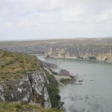
Bonfire Shelter, Archaeological site near Langtry, Texas, US

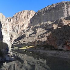
Bonfire Shelter is a natural rock overhang formed within a limestone cliff, containing layered deposits of bones and human artifacts from different time periods. The rock formation creates a sheltered space where ancient hunters left evidence of their occupation spanning thousands of years.

The shelter contains evidence of prehistoric bison hunting with the oldest layers dating back roughly 12,000 years. These remains rank among the earliest documented records of large-scale organized hunting in North America.

The site reveals hunting practices of early people through preserved stone tools and weapon points discovered during excavations. These artifacts show how hunting groups organized and carried out their work at this location.

Access to the site requires joining guided tours arranged through the nearby state park and advance registration is necessary. Visitors should be prepared for varied terrain and bring suitable hiking equipment for the walk.

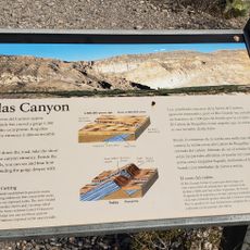
The site contains three distinct bone layers that record different hunting methods, including coordinated efforts to drive animals over the cliff edge. These separate layers reveal how hunting techniques changed and evolved over thousands of years.

The community of curious travelers

AroundUs brings together thousands of curated places, local tips, and hidden gems, enriched daily by 60,000 contributors worldwide.

Start exploring
GPS coordinates
29.81670,-101.55000
Latest update
December 11, 2025 11:09
Around this place
Amistad Reservoir
Mexico

Amistad Reservoir

62.7 km
Fort Clark
United States of America

Fort Clark

123.3 km
Pecos River High Bridge
United States of America

Pecos River High Bridge

19.7 km
Seminole Canyon State Park and Historic Site
United States of America

Seminole Canyon State Park and Historic Site

26.9 km
Amistad National Recreation Area
United States of America

Amistad National Recreation Area

64.3 km
Fort Lancaster
United States of America

Fort Lancaster

95.6 km
Rio Grande Wild and Scenic River
United States of America

Rio Grande Wild and Scenic River

94.8 km
La Linda International Bridge
Mexico

La Linda International Bridge

129.8 km
Lake Amistad Dam International Crossing
United States of America

Lake Amistad Dam International Crossing

62.7 km
Whitehead Memorial Museum
United States of America

Whitehead Memorial Museum

81.6 km
Mile Canyon
United States of America

Mile Canyon

218 m
United States of America

Tunas Peak

141.1 km
Canon Ranch Railroad Eclipse Windmill
United States of America

Canon Ranch Railroad Eclipse Windmill

111.2 km
Boquillas Canyon
United States of America

Boquillas Canyon

145.9 km
Mexico

Rio San Rodrigo

135.3 km
Crockett County Courthouse
United States of America

Crockett County Courthouse

105 km
Edwards County Courthouse and Jail
United States of America

Edwards County Courthouse and Jail

131.3 km
Sutton County Courthouse
United States of America

Sutton County Courthouse

121.2 km
Pecos River Bridge
United States of America

Pecos River Bridge

22.6 km
Fate Bell Shelter
United States of America

Fate Bell Shelter

26.4 km
Lower Pecos Canyonlands Archeological District
United States of America

Lower Pecos Canyonlands Archeological District

26.4 km
Seminole Canyon District
United States of America

Seminole Canyon District

26.4 km
Fort Lancaster State Historic Site
United States of America

Fort Lancaster State Historic Site

95.5 km
Princess Theater
United States of America

Princess Theater

89.1 km
Pecos River Boat Dock
United States of America

Pecos River Boat Dock

22.2 km
Chinati Foundation
United States of America

Chinati Foundation

125.9 km
Crockett County Jail
United States of America

Crockett County Jail

105.1 km
Boquillas Canyon Overlook
United States of America

Boquillas Canyon Overlook

150.1 km
Show the full map
Reviews
Share your experience

No review yet

Discussions
Start a discussion...

No discussion yet

« Bonfire Shelter - Archaeological site near Langtry, Texas, US » is provided by Around Us (aroundus.com). Images and texts are derived from Wikimedia project under a Creative Commons license. You are allowed to copy, distribute, and modify copies of this page, under the conditions set by the license, as long as this note is clearly visible.

Discover hidden gems everywhere you go!

From secret cafés to breathtaking viewpoints, skip the crowded tourist spots and find places that match your style. Our app makes it easy with voice search, smart filtering, route optimization, and insider tips from travelers worldwide. Download now for the complete mobile experience.

Around Us App Screenshot

A unique approach to discovering new places

Le Figaro

All the places worth exploring

France Info

A tailor-made excursion in just a few clicks

20 Minutes

Around Us
Travel Guide & Maps
Download

Send to your phone

QR Code
1

Open the camera app on your mobile.

2

Point at the QR code with your camera. A notification will appear.

3

Tap the notification to open the link.