Chest opened
+${chestReward.xp} XP
Explorer
NOUVEAU ×${chestReward.collectible.quantity}
tapez pour fermer
Chest locked

Open chests in the app

Around Us is built for your phone — chests unlock when you walk, explore and capture nearby places.

Enable Location

We need your location to show you interesting places around you

Discover nearby places

Find interesting locations and hidden gems around you

Precise directions

Get accurate directions and distances to places

Your location is never shared with other users. It's only used when you tap the location button.

Interstate 27

Log in to your account

Start exploring — it's free

Trusted by 72,881 travelers worldwide

Continue with Google
Continue with Apple
or

We will send you a code to connect

By continuing, you accept our Terms and Conditions and our Privacy Policy

Check your inbox

We've sent a pincode in your inbox. Please enter the code below.

Interstate 27
Discussion Reviews 1 Photos
19.9k Popularity

Interstate 27, Interstate Highway in Texas, United States

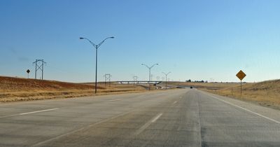
Interstate 27 is a highway in Texas that runs from Lubbock in the south to Amarillo in the north, following mostly the old U.S. Highway 87 route. The road passes through flat terrain across the Texas Panhandle, connecting several smaller towns like Abernathy, Hale Center, and Plainview before ending at a major interchange with Interstate 40 in Amarillo.

Interstate 27 was approved in 1968 and was not part of the original interstate system but was added later to the network. Construction progressed in stages, and the highway opened fully to traffic by 1992, with much of the route built upon older roads like U.S. Highway 87, which had existed for many years before the freeway was constructed.

The road is well marked with large signs and easy-to-read exit signs that help drivers find small towns or local roads. Traffic outside peak hours is steady, and the roadway is wide and designed for safe, smooth driving across the plains.

In Amarillo, a major project in 2001 reconfigured the interchange between Interstate 27 and Interstate 40 by building a bridge that allows traffic to flow smoothly without stops. This improvement shows how the infrastructure has evolved to meet growing traffic demands.

The community of curious travelers

AroundUs brings together thousands of curated places, local tips, and hidden gems, enriched daily by 60,000 contributors worldwide.

Start exploring
Location
Location
Location
Location
Location
Inception
1969
GPS coordinates
33.68617,-101.83605
Latest update
February 16, 2026 22:20
Around this place
Jones AT&T Stadium
United States of America

Jones AT&T Stadium

11.1 km
Yellow House Canyon
United States of America

Yellow House Canyon

37.9 km
Buddy Holly Center
United States of America

Buddy Holly Center

12 km
Lubbock Lake Landmark
United States of America

Lubbock Lake Landmark

8.7 km
Metro Tower
United States of America

Metro Tower

11.3 km
Dan Law Field at Rip Griffin Park
United States of America

Dan Law Field at Rip Griffin Park

11.5 km
Joyland Amusement Park
United States of America

Joyland Amusement Park

10.5 km
Reese Technology Center
United States of America

Reese Technology Center

21.6 km
Silent Wings Museum
United States of America

Silent Wings Museum

3.2 km
Museum of Texas Tech University
United States of America

Museum of Texas Tech University

11.6 km
Cactus Theater
United States of America

Cactus Theater

12 km
American Wind Power Center
United States of America

American Wind Power Center

11.7 km
Lubbock Texas Temple
United States of America

Lubbock Texas Temple

20 km
Lubbock Memorial Civic Center
United States of America

Lubbock Memorial Civic Center

11 km
Administration Building
United States of America

Administration Building

12 km
Texas Technological College Dairy Barn
United States of America

Texas Technological College Dairy Barn

12.3 km
Lubbock Post Office and Federal Building
United States of America

Lubbock Post Office and Federal Building

11.3 km
Texas Technological College Historic District
United States of America

Texas Technological College Historic District

11.9 km
Kress Building
United States of America

Kress Building

11.3 km
Carlock Building
United States of America

Carlock Building

11.5 km
Warren and Myrta Bacon House
United States of America

Warren and Myrta Bacon House

11.5 km
Wells Fargo Building
United States of America

Wells Fargo Building

11.4 km
Adventure Park
United States of America

Adventure Park

15.2 km
Tubbs-Carlisle House
United States of America

Tubbs-Carlisle House

13.7 km
Blazing Bouncers
United States of America

Blazing Bouncers

21.8 km
Lubbock Water Rampage
United States of America

Lubbock Water Rampage

19.8 km
Holden Properties Historic District
United States of America

Holden Properties Historic District

12.9 km
National Ranching Heritage Center
United States of America

National Ranching Heritage Center

11.6 km
Show the full map
Reviews
Share your experience

No review yet

Discussions
Start a discussion...

No discussion yet

« Interstate 27 - Interstate Highway in Texas, United States » is provided by Around Us (aroundus.com). Images and texts are derived from Wikimedia project under a Creative Commons license. You are allowed to copy, distribute, and modify copies of this page, under the conditions set by the license, as long as this note is clearly visible.

Discover hidden gems everywhere you go!

From secret cafés to breathtaking viewpoints, skip the crowded tourist spots and find places that match your style. Our app makes it easy with voice search, smart filtering, route optimization, and insider tips from travelers worldwide. Download now for the complete mobile experience.

Around Us App Screenshot

A unique approach to discovering new places

Le Figaro

All the places worth exploring

France Info

A tailor-made excursion in just a few clicks

20 Minutes

Around Us
Travel Guide & Maps
Download

Send to your phone

QR Code
1

Open the camera app on your mobile.

2

Point at the QR code with your camera. A notification will appear.

3

Tap the notification to open the link.