Enable Location

We need your location to show you interesting places around you

Discover nearby places

Find interesting locations and hidden gems around you

Precise directions

Get accurate directions and distances to places

Your location is never shared with other users. It's only used when you tap the location button.

Magnolia Plantation

Log in to your account

Start exploring — it's free

Trusted by 62,472 travelers worldwide

Continue with Google
Continue with Apple
or

We will send you a code to connect

By continuing, you accept our Terms and Conditions and our Privacy Policy

Check your inbox

We've sent a pincode in your inbox. Please enter the code below.

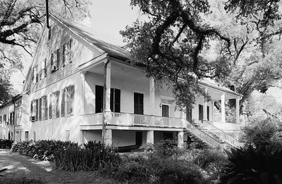
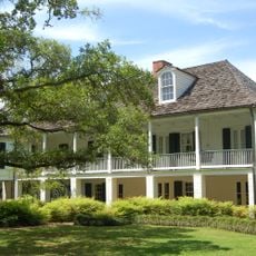
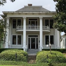
Magnolia Plantation, Agricultural plantation in Natchitoches Parish, United States

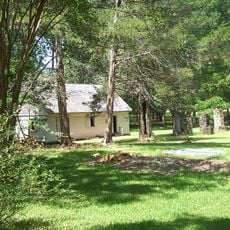
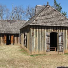
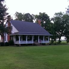
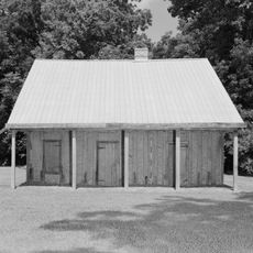
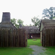
Magnolia Plantation is a historic site in Natchitoches Parish featuring preserved brick structures including an overseer's house, eight worker cabins, a blacksmith shop, and a cotton gin barn along Cane River. These buildings represent different aspects of agricultural operations from earlier centuries.

The site was founded in the 1830s and quickly grew into the largest cotton production center in the area. By the mid-1800s, it employed hundreds of people across its operations.

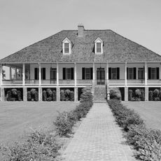
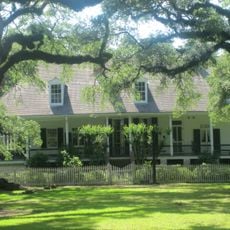
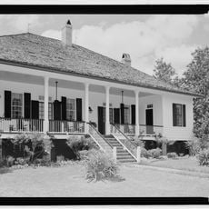
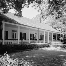
The buildings combine French colonial style with Caribbean influences, visible in the brick construction and Tuscan columns throughout the site. This blend of architectural styles reflects how different cultures shaped the region's development.

Visitors can explore the outbuildings on their own during daily visits and walk around the grounds at their own pace. The main house is not open to the public because it remains a private residence.

The eight brick worker cabins reveal a long story of use, first housing enslaved families and later occupied by tenant farmers over many decades. This transition from one era to another is visible in the buildings themselves.

The community of curious travelers

AroundUs brings together thousands of curated places, local tips, and hidden gems, enriched daily by 60,000 contributors worldwide.

Start exploring
GPS coordinates
31.54972,-92.94056
Latest update
December 7, 2025 20:43
Around this place
Melrose Plantation
United States of America

Melrose Plantation

6.1 km
Los Adaes
United States of America

Los Adaes

37.8 km
Cane River Creole National Historical Park
United States of America

Cane River Creole National Historical Park

14.2 km
Oaklawn Plantation
United States of America

Oaklawn Plantation

15 km
Fort Jesup
United States of America

Fort Jesup

44.2 km
Oakland Plantation
United States of America

Oakland Plantation

14.1 km
Black Lake
United States of America

Black Lake

46.5 km
Harry Turpin Stadium
United States of America

Harry Turpin Stadium

26.5 km
Fort St. Jean Baptiste State Historic Site
United States of America

Fort St. Jean Baptiste State Historic Site

26.5 km
Kate Chopin House
United States of America

Kate Chopin House

2.4 km
Cherokee Plantation
United States of America

Cherokee Plantation

17.9 km
Basilica of the Immaculate Conception
United States of America

Basilica of the Immaculate Conception

27.3 km
Rebel State Historic Site
United States of America

Rebel State Historic Site

26.2 km
Natchitoches Historic District
United States of America

Natchitoches Historic District

26.9 km
Narcisse Prudhomme Plantation
United States of America

Narcisse Prudhomme Plantation

14.9 km
Eden
United States of America

Eden

34.8 km
Badin-Roque House
United States of America

Badin-Roque House

6.6 km
Caspiana Plantation Store
United States of America

Caspiana Plantation Store

28.7 km
Church of St. Anne
United States of America

Church of St. Anne

41.9 km
Robeline Methodist Church
United States of America

Robeline Methodist Church

37.9 km
Mayer Hirsch House
United States of America

Mayer Hirsch House

33.2 km
Old Courthouse Museum
United States of America

Old Courthouse Museum

27.4 km
Jones House
United States of America

Jones House

4.2 km
Fort St. Jean Baptiste
United States of America

Fort St. Jean Baptiste

26.5 km
Port of Natchitoches
United States of America

Port of Natchitoches

33.8 km
Natchitoches Parish Library
United States of America

Natchitoches Parish Library

41.4 km
Bank of Montgomery Washington Street Branch
United States of America

Bank of Montgomery Washington Street Branch

27.6 km
Church Street Bridge
United States of America

Church Street Bridge

27.2 km
Show the full map
« Magnolia Plantation - Agricultural plantation in Natchitoches Parish, United States » is provided by Around Us (aroundus.com). Images and texts are derived from Wikimedia project under a Creative Commons license. You are allowed to copy, distribute, and modify copies of this page, under the conditions set by the license, as long as this note is clearly visible.

Discover hidden gems everywhere you go!

From secret cafés to breathtaking viewpoints, skip the crowded tourist spots and find places that match your style. Our app makes it easy with voice search, smart filtering, route optimization, and insider tips from travelers worldwide. Download now for the complete mobile experience.

Around Us App Screenshot

A unique approach to discovering new places

Le Figaro

All the places worth exploring

France Info

A tailor-made excursion in just a few clicks

20 Minutes

Around Us
Travel Guide & Maps
Download

Send to your phone

QR Code
1

Open the camera app on your mobile.

2

Point at the QR code with your camera. A notification will appear.

3

Tap the notification to open the link.